

Results 401 to 420 of 2961
Thread: Where is it? (Poor mans version)
-
01-21-2011, 11:52 AM #401
-
01-21-2011 11:52 AM # ADS
-
01-21-2011, 12:12 PM #402I wasn't sure whether anyone would get it from this angle
At my wife's family reunions, they used to rappel off that small cliff, so I've seen it from that angle.
Hint: This should be easy, but I won’t tell you why it should be easy.Utah is a very special and unique place. There is no where else like it on earth. Please take care of it and keep the remaining wild areas in pristine condition. The world will be a better place if you do.
-
01-21-2011, 12:23 PM #403now wait a minute. dont i get to tell you if its been guessed correctly? and it is on the road into the maze from hite. andy miller flats. looking back to the west towards mt holmes and mt. ellsworth.
 Originally Posted by oldno7

thought you might appreciate it. Originally Posted by Scott P
 so, you see i didn't have to cheat much.
But if I agreed with you, we would both be wrong.
so, you see i didn't have to cheat much.
But if I agreed with you, we would both be wrong.
-
01-21-2011, 12:48 PM #404Bogley BigShot


- Join Date
- May 2007
- Location
- We're all here, because we ain't all there.
- Posts
- 19,424
Why yes, yes you do..... Originally Posted by denaliguide
Are we close?
-
01-21-2011, 01:34 PM #405
yea you were right.
 But if I agreed with you, we would both be wrong.
-
01-21-2011, 03:24 PM #406Colorado River, Pyramid Butte Originally Posted by Scott P
-
01-21-2011, 05:48 PM #407Yes. It was taken last weekend from above Horse Bottom. The mini-trip report is posted below:Colorado River, Pyramid Butte
http://www.bogley.com/forum/showthre...-something-newUtah is a very special and unique place. There is no where else like it on earth. Please take care of it and keep the remaining wild areas in pristine condition. The world will be a better place if you do.
-
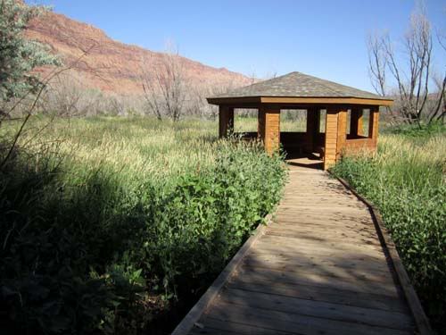
01-21-2011, 07:34 PM #408
This could be tough - unless, of course, you've been here.
-
01-21-2011, 07:37 PM #409
I have no idea, but the boardwalk and viewing hut would indicate a bog or marsh area.
Some people "go" through life and other people "grow" through life. -Robert Holden
-
01-23-2011, 12:28 AM #410
the matheson preserve boardwalk area outside of moab?
Tear down Dams, Build up Dreams!
-
01-23-2011, 06:40 AM #411You got it, the viewing blind in the wetlands preserve. Originally Posted by fouristhenewone
Your turn.
-
01-25-2011, 10:49 AM #412Woot! Originally Posted by slickrocker
My Turn
Tear down Dams, Build up Dreams!
-
01-25-2011, 11:03 AM #413
Is that the road coming out of Hidden Splendor?
-
01-25-2011, 11:10 AM #414
nope - but in that general area.
Tear down Dams, Build up Dreams!
-
01-25-2011, 12:02 PM #415
Little Wildhorse Road heading East. Pic taken further west of LWH.
-
01-25-2011, 12:15 PM #416Content Provider Emeritus
- Join Date
- Feb 2005
- Location
- Quiet and charming: Mount Carmel
- Posts
- 7,158
I'm thinking, off I-70, the road heading south toward the top of the Moroni Slope...?? But Little Wildhorse Road sounds like a good guess too.
Tom
-
01-25-2011, 12:40 PM #417
i'm with the little wildhorse road looking north.
But if I agreed with you, we would both be wrong.
-
01-25-2011, 01:48 PM #418Content Provider Emeritus
- Join Date
- Feb 2005
- Location
- Quiet and charming: Mount Carmel
- Posts
- 7,158
Although... I'm more thinking it is looking south, little wild horse mesa on the left. Tom Originally Posted by ratagonia
-
01-25-2011, 02:09 PM #419
wrong wrong wrong, I was there.
figured Dennis would nail this one instantly
-
01-25-2011, 02:25 PM #420
My first though was Little Flat Top, heading west out of the San Rafael Desert. But I checked my photos and that's not it. It's definitely not along the Little Wild Horse road because the Summerville layers are much higher up along the entire length of that road between GV and the LWHC parking lot (it's all Entrada Sandstone down at the level of the road). So, I'm going to have to go with the Green River Cutoff Road, where it passes near the highest point of the Woodside Anticline. There's really not a name for this specific location, but it's about halfway between El Rancho Not So Grande and US-6.
Edit: The more I think about this, the more I'm sure of my guess. Check out pages 11 and 15 of Desert Magazine from June 1951 for photos of the same formation: http://www.scribd.com/doc/2403358/19...zine-1951-June
I've done some exploring around there and have even been up on the southern flank of that butte on an old mining road.


 Reply With Quote


Similar Threads
-
Poor Chair (PIC)
By accadacca in forum General DiscussionReplies: 19Last Post: 10-20-2010, 12:08 PM -
Fat Mans Misery
By Pubalz in forum CanyoneeringReplies: 5Last Post: 04-06-2010, 04:07 PM -
My poor kid *LOLZ*
By LOAH in forum General DiscussionReplies: 1Last Post: 10-31-2009, 11:53 AM -
Poor Julio
By CrazyFinn in forum The Political ArenaReplies: 33Last Post: 02-13-2009, 08:51 PM -
poor bubba
By MTpockets in forum JokesReplies: 0Last Post: 02-27-2007, 01:47 PM
Visitors found this page by searching for:
Outdoor Forum
