

Results 1 to 20 of 21
Thread: Dark Canyon
-
04-14-2008, 02:37 PM #1
Dark Canyon
Anyone done Dark Canyon yet this year and have beta? Anything I should be concerned about going next week? Never done it before. Is 60 cfs likely to be a problem with the East Fork exit? (I do see the escape route at the Parunuweap/EFVR junction from Shane's site.)
Can you see the bottom?
-
04-14-2008 02:37 PM # ADS
-
04-14-2008, 02:44 PM #2
Dark Canyon

You mean Rock Canyon?

-
04-14-2008, 02:49 PM #3Zions the "s" is silent

- Join Date
- Nov 2007
- Location
- indoors wanting to be outdoors
- Posts
- 3,216
QFE please provide beta on this mystery Dark Canyon so I can hit it Originally Posted by Iceaxe

-
04-14-2008, 03:16 PM #4Bogley BigShot

- Join Date
- May 2007
- Location
- We're all here, because we ain't all there.
- Posts
- 19,424
I'm a little confused--Isn't EFVR the same as Parunaweap? Other than ones water and ones a canyon?
Lots a stuff out there is dark.(well not lots)
More info please
-
04-14-2008, 03:18 PM #5
I stumbled upon this while searching for something else.
http://bogley.com/forum/viewtopic.ph...t=camping+zionThe man thong is wrong.
-
04-14-2008, 03:22 PM #6Zions the "s" is silent
- Join Date
- Nov 2007
- Location
- indoors wanting to be outdoors
- Posts
- 3,216
Yes EFVR is Parunaweap but Parunaweap is closed through the park. Now my turn to ask a question. Is it closed at the park boundry or at Labyrinth Falls? Because I've heard both. Originally Posted by oldno7
-
04-14-2008, 03:35 PM #7Officially it's closed at the Park Boundary.... Originally Posted by trackrunner
Unofficially it's closed at the Falls.
Which means you can visit the falls from the top and probably never have a problem....

-
04-14-2008, 03:36 PM #8Zions the "s" is silent
- Join Date
- Nov 2007
- Location
- indoors wanting to be outdoors
- Posts
- 3,216
Thanks. I'll just say I missed the exit out and am now back tracking to the exit. Originally Posted by Iceaxe

-
04-14-2008, 03:39 PM #9
There is a Dark Canyon and it's really an awesome canyon. The problem is that Dark Canyon (the same one mentioned in the thread) is located where the Colorado empties into Lake Powell and is no where near Zion.
We used to access with our boats and hike up Dark Canyon from the lake, but no way in hell you could get a boat near there right now.
-
04-14-2008, 04:29 PM #10
Rock, not Dark
Uh, check that on DARK Canyon, which is very pleasant this time of year. But I meant to say ROCK canyon. I wish I could fire my editor.
Can you see the bottom?
-
04-14-2008, 04:38 PM #11
And Another Thing
And yes, that's the EFVR/Rock Canyon junction. Sorry for the confusion. So, now that we've got that cleared up, and I've supplied enough evidence to convict me of terminal idiocy, sounds like Rock will probably be OK?
And yeah, totally agree on Dark Canyon. Beautiful place, nice pools, but the talus hike in/out on the Sundance Trail is pretty brutal. But that's another subject ... er, canyon.Can you see the bottom?
-
04-14-2008, 04:41 PM #12
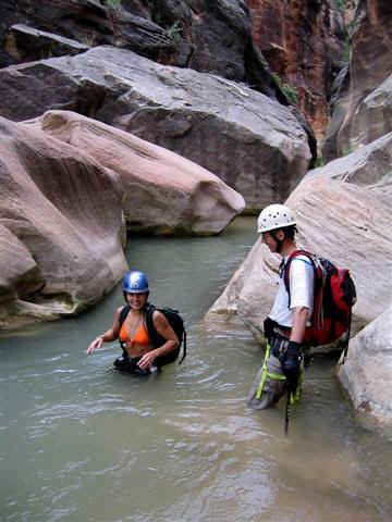
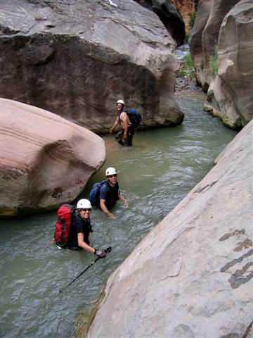
Not sure what gauge you are using.... but a true 60cfs through Parunuweap should not be a problem. I think you could pretty much do the canyon at double that but haven't tried. The only real danger in Parunuweap is a constriction that sometimes becomes a strainer. The constriction/strainer is located below French Canyon and above Misery. Parunuweap doesn't really start to get tight until you hit the confluence with Misery.
Photo of constriction that sometimes becomes a strainer.
-
04-14-2008, 04:42 PM #13
watch for the ichy plant life going out French...
-
04-14-2008, 05:13 PM #14
Re: Dark Canyon
Make sure you've got 4WD. We did it last year in late May and it was pretty balls to the wall. Lots of sections where you'd go in at 40 mph and exit at 5 mph. Scraped up the sides of my ford f150 in a couple of tight spots. Originally Posted by Mudcat
I also echo the sentiment to watch out for poisen ivy in french. There's a ton of it.beefcake. BEEFCAKE!
-
04-14-2008, 06:34 PM #15
Using USGS for EFVR (http://waterdata.usgs.gov/ut/nwis/uv?09404900) which shows flows hovering around 61 for the past week. I'm assuming neo isn't necessary, except maybe on the feet. If I'm wrong, someone please let me know.
Thanks for the warning on the poison ivy. I hate that stuff!Can you see the bottom?
-
04-14-2008, 06:51 PM #16Zions the "s" is silent
- Join Date
- Nov 2007
- Location
- indoors wanting to be outdoors
- Posts
- 3,216
Actualy someone posted a TR on another site (yahoo) from this last Saturday. They said a full wetsuit was not needed but a shorty was nice, waist deep water. Also the person said there was ratty fixed webbing (whatever that is Originally Posted by Mudcat
) on every drop, bring some webbing.
Also the gauge you have is the East Fork of Virgin at Springdale. As Tom Jones pointed out since you'll be up canyon the flow will be less than what is on the website.
-
04-15-2008, 05:59 AM #17
Thanks Trackrunner. I did try to search it before I asked, but wasn't successful. Could you be referring to the Fat Man's Misery TR? Good point--that beta is applicable once in the East Fork. I'm guessing Rock itself is not too wet?
We'll bring pack capacity to clean the old webbing.Can you see the bottom?
-
04-15-2008, 06:08 AM #18Bogley BigShot
- Join Date
- Oct 2005
- Location
- Just a few miles from Zion National Park
- Posts
- 8,456
Yeah.. the worst part is that it's at chest level!!! The first time through the guys I was with were holding it back with a stick... dang!!! Originally Posted by marc olivares
All I can say is that those chlorine and baking soda (think that is what it was) baths help.
The other times through I found it was simply better to just bend back at your knees and lean way back.
There is lots of that itchy plant life along the banks of Pweap it looks like but I have walked through that before I noticed and had no affects?
-
04-15-2008, 08:26 AM #19If you can do Misery safely you can do Rock. The section of P-weap between Misery and the horseshoe exit is tighter then anything between Rock and French. Originally Posted by Mudcat
From locals I'm told the road out to Rock isn't to bad in the spring, but turns to soft deep sand by mid summer. For some reason they say it always firms up some over the winter. YMMV... I say a 4x4 and shovel are mandatory equipment.
-
04-15-2008, 08:51 AM #20Bogley BigShot
- Join Date
- May 2007
- Location
- We're all here, because we ain't all there.
- Posts
- 19,424
Very true---(rock) Originally Posted by Iceaxe
I think the best exit is on the left ridge(ldc) as you exit the bottom of the canyon. Slight scrambling up to the end of a good 4x4 trail. Then hike the trail back to your vehichle. Saw very fresh and very large cougar track in there last year.(on trail out)
And for the anti ATV crowd--2 atv's work very well as a shuttle out of this canyon. Or so I've been told


 Reply With Quote


Similar Threads
-
Dark Canyon
By kris in forum Hiking, Scrambling & Peak BaggingReplies: 3Last Post: 02-08-2009, 06:59 AM -
Dark Canyon in June (and I really mean Dark Canyon)
By Mudcat in forum CanyoneeringReplies: 3Last Post: 05-05-2008, 09:34 AM -
[Trip Report] Dark Canyon
By TreeHugger in forum Backpacking & CampingReplies: 11Last Post: 06-11-2007, 09:28 PM -
Dark Canyon
By TreeHugger in forum Backpacking & CampingReplies: 16Last Post: 05-01-2007, 08:02 PM -
[Trip Report] Dark Canyon
By Cirrus2000 in forum Backpacking & CampingReplies: 8Last Post: 10-24-2006, 02:43 PM
Visitors found this page by searching for:
Outdoor Forum

