

Results 1 to 6 of 6
Thread: Boulder Mountain
-
06-30-2015, 10:41 AM #1
Boulder Mountain
I spent the better part of yesterday behind bars. Handlebars, that is. (See what I did there?) Our group of eight, led by Lyman, explored Boulder Mountain on dirt bikes. I'd previously hiked with all of the group members on different occasions, but this time it was a pleasure to spend some time with and learn from Lyman. Alan and I loaded our motorcycles into his van the previous evening and then left Price early the next morning and met up with some others at Wade's house in Ferron. We staged near the Aquarius Guard Station at the base of Boulder Mountain where we met Lyman and Josh. We got rolling at about 9:45 and headed generally south until picking up a road that led east onto Boulder Top. There were a few interesting stops along the way, including one by me when I dropped my motorcycle while trying to climb out of a rut in the road. Luckily it was my only major mishap of the trip.
Staging area near the Aquarius Guard Station

Cabin at the bottom of the Miller Creek Trail

Dark Valley

Half-Track at Row Lakes

Field of dandelions

This trip was actually supposed to happen the previous weekend but the Forest Service hadn't yet opened the gates onto Boulder Top due to snow drifts. The one-week delay made a big difference and we climbed up onto the plateau without encountering any snow on the road. We lunched at Spectacle Lake and then continued across Boulder Top on the way to Bown's Point. One part of the road along the way crossed through Bakeskillet Lake. Wade braved through it first and then everyone followed. At the next major road junction we ran into a couple of vehicles, one of which was piloted by a good friend of Josh--another one of those "small world" moments.
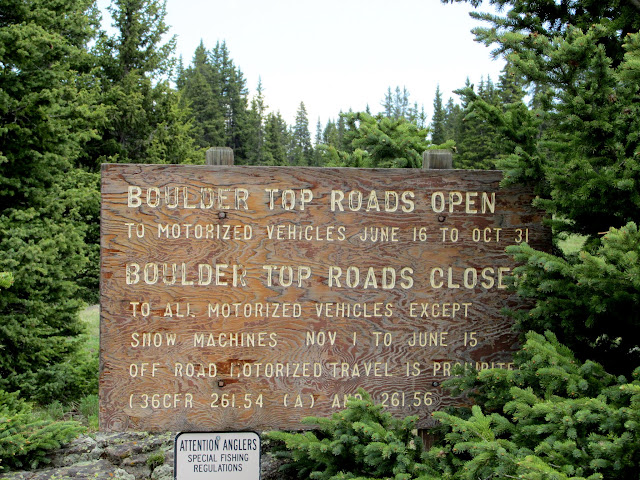
Sign at Boulder Top near South Point
Cabin at Spectacle Lake

One of several beetles that landed on me

Spectacle Lake

Alan and Paul riding through Bakeskillet Lake

One of these things is not like the others

Talking to some of Josh's friends that we bumped into

Stink Draw

Pot leaf carving

Cabin near Oak Draw

Mosquito feeding on me

Nearing Bown's Point

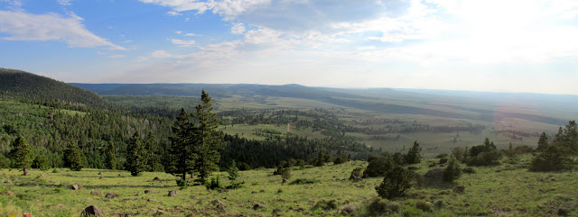
The view east from Boulder Mountain is unparallelled. You can get a good taste of it from Highway 12 on the eastern flank of Boulder Mountain, but that's 1,500 to 2,000 feet below where we stood. From Bown's Point we could see Capitol Reef and the Henry Mountains and beyond. Almost every color imaginable is visible in the vegetation and geology for as far as one can see. To get a better view to the north we hiked the Great Western Trail for a short distance.
Top of stock trail at Bown's Point

View across Capitol Reef toward the Henry Mountains

Capitol Reef in the foreground and the San Rafael Reef faintly visible in the distance

Lower Bown's Reservoir

Trail sign

Long Lake

Blazed tree along the Great Western Trail

It took some backtracking to the northwest until we hit another road leading east to Chokecherry (Tantalus) Point. It rained for much of that part of the ride, and I think the thunder had at least a few of us worried. The rain eased as we stopped for another hike along the Rim Trail to Chokecherry Point. At the point was a visitor register in a tea tin, but historically there was a different register that was visited by explorers, hunters, sheep and cattle herders, and other pioneers. The view from Chokecherry Point was much the same as from Bown's Point, except one could see farther north from Chokecherry.
Road across a meadow at Oak Draw

Road across Oak Draw

Intersection at Stink Flats

Road near Chokecherry Point

Rim Trail leading to Chokecherry Point

Visitor register at Chokecherry Point

Cluster of Asteraceae growing in basalt rocks

Part of the survey tower from 1934

Fins in Capitol Reef

Jorgenson Flat

We took a more direct route back to our vehicles, with a quick stop to hike Bluebell Knoll, the highest point in Wayne County at 11,317' in elevation. It turned out to be my 10th county high point in Utah--only 19 left to go! The mosquitoes were at their worst on Bluebell Knoll, and I'm glad it was late enough in the day that nobody wanted to spend much time there. :) It was an easy gravel road from there back to our vehicles, but we'd seen a huge variety of road conditions during the day. From gravel, dirt, mud, snow, and rocks, we'd seen just about everything except sand and ice. My previous motorcycle experience hadn't prepared me at all for this trip. At the beginning I felt uneasy and always on the edge of control, but by the end of the trip I was cruising easily and feeling completely comfortable on the rough, rocky roads.
Beef Meadows

Group photo at the Bluebell Knoll sign

Gentle uphill climb to Bluebell Knoll

Geocache at Bluebell Knoll

Pond southeast of Bluebell Knoll

Mosquitoes attacking

View southwest off Boulder Mountain
GPS at the end of the ride

Photo Gallery: Boulder Mountain
GPS Track and Photo Waypoints:
[Google Earth KMZ] [Gmap4 Satellite] [Gmap4 Topo]
-
Post Thanks / Like - 2 Likes
-
06-30-2015 10:41 AM # ADS
-
06-30-2015, 11:52 AM #2
Awesome! Looks like a great ride. Excellent photos!

-
07-01-2015, 01:51 AM #3
SHIT U dink now I have to eat my stupiud words with the ATV thing. THe cool part is out on motos nobody gives as rats ass . Now I feel like a real dork.Ask me if I care?
So can you keep up or are you just getting started?
WOULD love to show you the other end of things if your up for it. Bikes can go so many more places that an ATV. It just gets more real is all.If you want to ride let's ride and if you want an attitude well we just need to do some more ridding.
Life is good and life is fare.
-
07-13-2015, 11:30 AM #4
Great TR. Sounds like a big day for sure. Those trails down to spectacle lake and out to chokecherry are good stuff. I'll be there in a couple of weeks spending 12 days in August up there. We'll be staying at Posey Lake and day tripping each day on our dirt bikes out to various lakes to fish. Hoping to fish 25-30 lakes over 10 days. Do you have a gps track of your route? I'd be interested in seeing it. Were there any areas that were sketchy or hard on a dirt bike? My brother is fairly inexperienced on a dirt bike and I don't want to get him onto something nasty. How was that 4 wheeler trail between blue bell knoll and spectacle? How was the Dark valley trail? What route did you take from Dark Valley to the Row Lakes?
Thanks.beefcake. BEEFCAKE!
-
07-13-2015, 12:53 PM #512 days on the Boulder sounds awesome! There are links to my track/maps at the bottom of the TR.
 Originally Posted by nelsonccc

I'm pretty inexperienced as well--this was the roughest terrain I'd ridden. The only parts I remember being difficult were the climb from Row Lakes to Purple Lake and the descent to Chokecherry Point, which were both steep and rocky. The road between Spectacle and Bluebell wasn't bad at all. Dark Valley was pretty easy, though that is the only place where I dropped my bike on this trip while trying to climb out of a rut. From Dark Valley we went through Rock Spring Draw to the 154 road, then up the GWT to Row Lakes.
-
07-14-2015, 02:34 PM #6I totally missed the gps tracks. Thanks. Looks like you pretty much went were I thought you had. I'm super excited about the trip for sure. Lots of fishing and scouting for hunting. Should be a good time. Originally Posted by Udink
beefcake. BEEFCAKE!


 Reply With Quote


Similar Threads
-
[Trip Report] Boulder Mountain Day Trip?
By LOAH in forum FishingReplies: 0Last Post: 05-23-2012, 10:18 AM -
Boulder Mountain Help
By Deadeye008 in forum FishingReplies: 0Last Post: 09-15-2011, 11:55 AM -
[Trip Report] Boulder Mountain
By Wasatch Rebel in forum Backpacking & CampingReplies: 5Last Post: 08-04-2011, 09:23 PM -
Looking for a guidebook for Boulder Mountain
By uintahiker in forum Hiking, Scrambling & Peak BaggingReplies: 3Last Post: 04-18-2011, 08:46 AM -
Boulder Mountain info
By uintafly in forum Backpacking & CampingReplies: 3Last Post: 04-05-2011, 05:53 AM
