

Results 1 to 4 of 4
Thread: McCarty Canyon
-
03-06-2015, 11:26 AM #1
McCarty Canyon
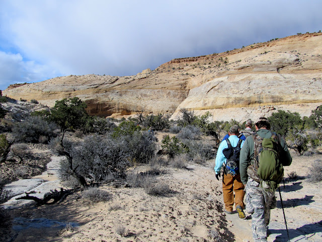
On the 21st--yet another mild February day--I tagged along on a trip that Wade planned into McCarty Canyon. I absolutely love this type of route! Several parts of Wade's route looked impossible from the satellite views, but in reality it worked out to be a wonderful hike with some scrambling required for the big elevation changes into and out of canyons. Alan carpooled with me and we met the rest of the group at Yellow Seep, east of Ferron. The group totaled 10 people and one dog: me, Alan, Josh, Wade and his family (and Sophie the dog), and Shane and his family. From Yellow Seep we followed cattle trails across relatively flat ground. Alan and I were bringing up the rear when we took a short detour to see some pit structures that he'd visited before. We crossed Mesquite Wash and caught up with the rest of the group at the rim of McCarty Canyon.
Hiking near Yellow Seep

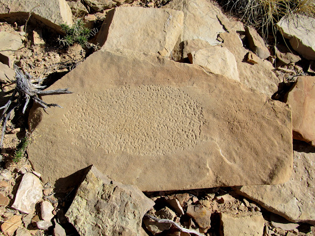
Grinding stone
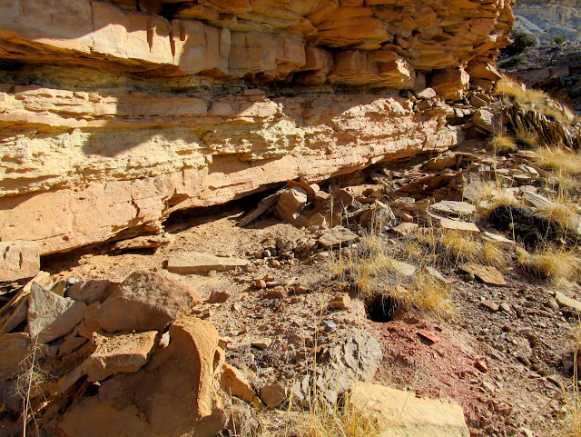
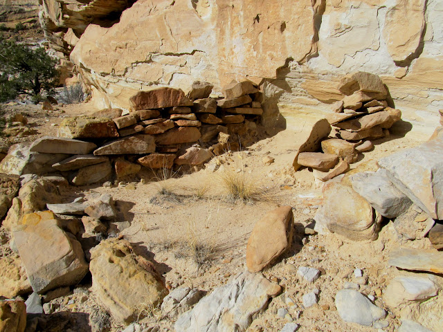
Overhang with several small pit structures below
Pit structure

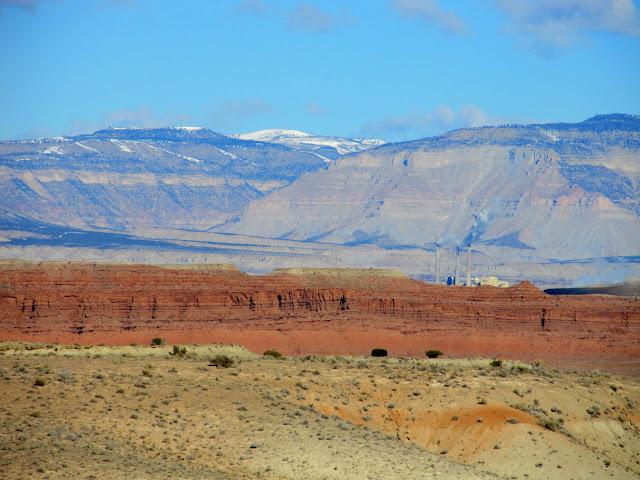
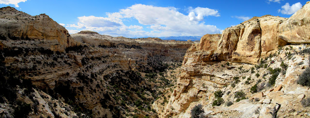
Red Ledges, Hunter Power Plant, and Wasatch Plateau
Mesquite Wash

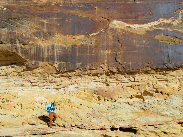
The descent into McCarty involved a little bit of scrambling. At the main watercourse we traveled upstream a short distance and then entered Little Fork. None of the forks of McCarty Canyon have official names, but Wade's in-laws run cattle in the area so he called them by their locally-known names. In Little Fork we saw some old cowboy inscriptions dating to well over 100 years ago. There was also a cairn visible one cliff band above the canyon, and we found a way to scramble up to it hoping that it marked something interesting but, alas, it was just a pile of rocks.
Dropping into McCarty Canyon

View back up our entry route into McCarty Canyon
Wade packing out some trash

McCarty Canyon

1890 Warren Allred

Old fence

Scrambling up to a shelf above the canyon

Cairn above McCarty Canyon

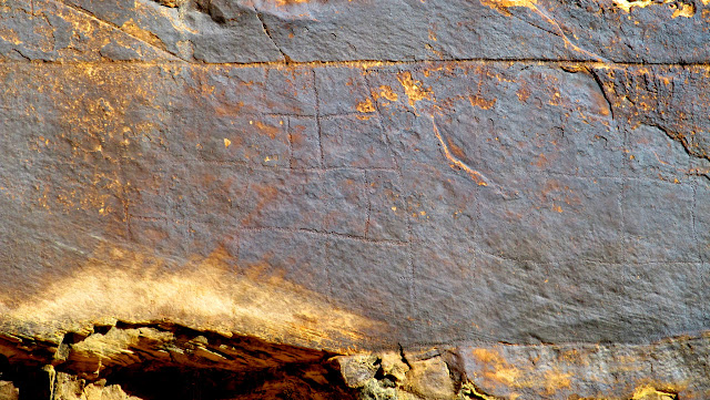
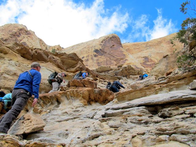
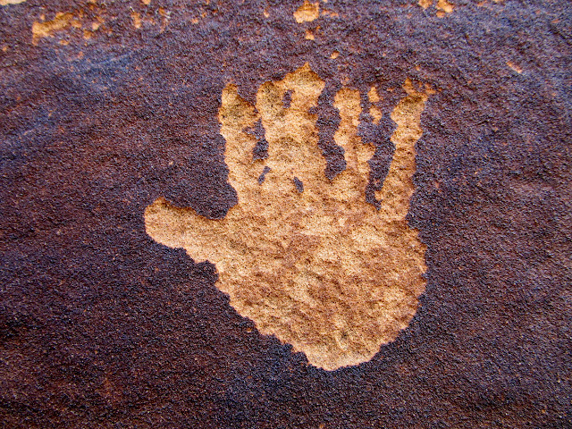
Farther up the canyon was a really amazing petroglyph panel. It was difficult to see because the rock art had been re-covered in patina. Had the glyphs been clearly legible, this would probably be a very popular destination for rock art lovers. The head of Little Fork looks like a dead-end, but there's an unlikely route through the cliffs that leads to the top. We took a break just below the canyon rim for lunch.
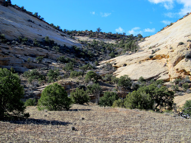
Amphitheatre above Little Fork

Alan below a dark wall full of hard-to-see petroglyphs
Repatinaed petroglyphs

Large grid petroglyph
Navajo Sandstone peaks above Little Fork

Approaching the head of Little Fork

The exit route from Little Fork

Climbing out of Little Fork
A lone petroglyph panel
Small natural arch near the top of Little Fork

Lunch spot

Lunch for a few of the group

Small pine tree at a seep

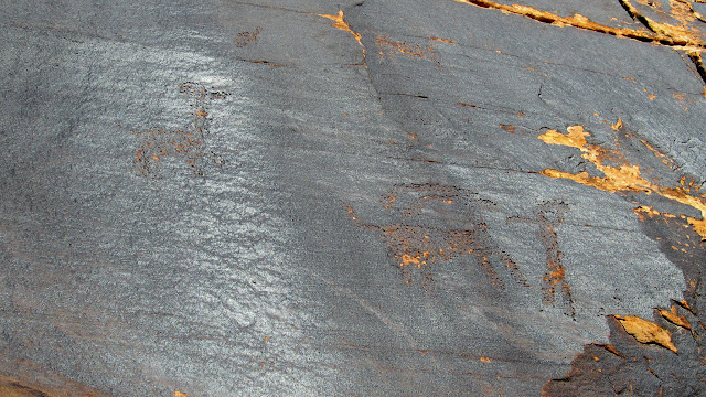
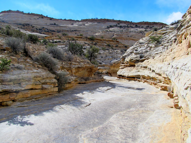
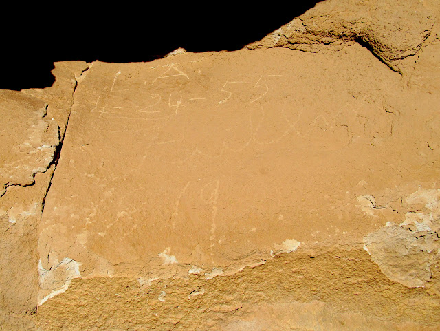
We picked up a horse trail just above the rim of Little Fork and began to follow it downhill into Still Fork. There we found some more rock art and a very interesting 1879 inscription, which was very early for a white man to be exploring this area.
Final route leading to the top of Little Fork

View down Little Fork
Sophie

Horse trail leading to Still Fork

View down Still Fork of McCarty Canyon

Walking the trail into Still Fork
Spherical concretions that have been eroded by horse traffic across the sandstone

Still Fork
Tree and cliff reflected in a pool

Backpackers

Three legs

Ballerina

Count Rugen was here
Old rock wall in Still Fork
L.A. 4-24-55 and Fullmer 1879
At the confluence of Still Fork with McCarty Canyon we visited an old dugout structure and cowboy camp. We headed downstream in McCarty and climbed back out of the canyon and followed cow paths back to the vehicles. It was a wonderful 10.8 miles of hiking in a little over eight hours. This area seems to be little-explored except by a few locals. My time there felt like a very brief introduction to a place that begs for more exploration, and that might still hold some secrets.
Collapsed dugout cabin in McCarty Canyon
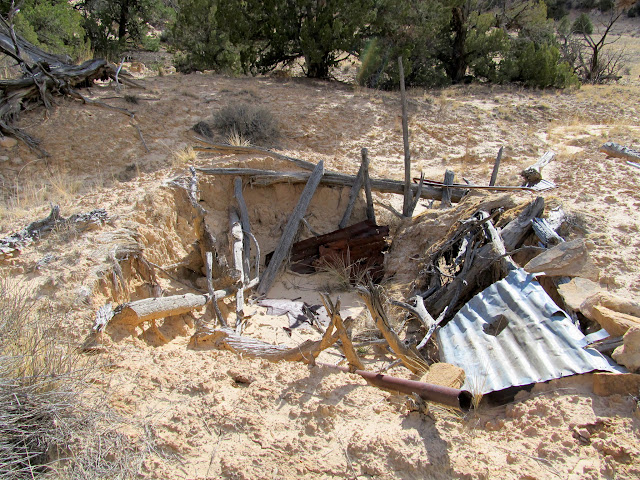
Juniper bark roof

McCarty Canyon

Remains of a stove at an old cowboy camp

Exit route from McCarty Canyon

Between McCarty Canyon and Mesquite Wash

A distant Wasatch Plateau to the west, with Straight Canyon on the left and Cottonwood Canyon on the right

Wildflower that was tricked into blooming early: Spring Parsley (Cymopterus purpurascens)

Vehicles parked at Yellow Seep

Hike stats: 10.8 miles in 8.25 hours
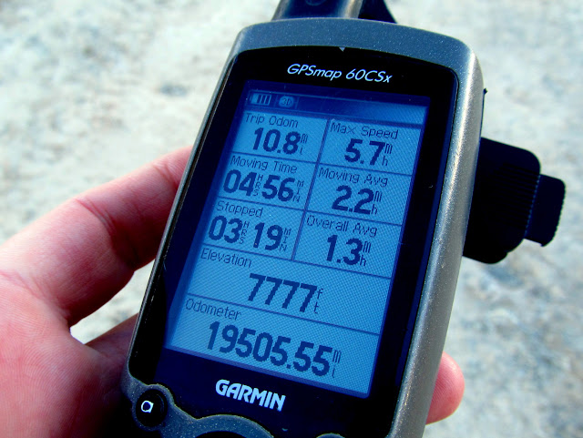
Photo Gallery: McCarty Canyon
GPS Track and Photo Waypoints:
[Google Earth .KMZ] [Gmap4 Satellite] [Gmap4 Topo]
-
Post Thanks / Like - 3 Likes
-
03-06-2015 11:26 AM # ADS
-
03-08-2015, 06:08 PM #2
McCarty is one of my favorite rides. Really gets you off the beaten path and away from most people.
We drop down into salt wash and cross it and head over to McCarty

There is some quick sand in Sand Wash that you have to be careful about. This horse stepped in and buried his front half in one step.

We ride across some high places and drop down and pick up the trail you can see in the bottom

Riding up the bottom of McCarty

Part way up McCarty is a side canyon that you follow up ( I was told it was called Still canyon because it's where the outlaws hid there still.

This side canyon has a slick rock floor

The canyon gets narrower and eventually you have to climb up over a couple of steps. Shortly after those you scramble up the right side to get out of the canyon and get up on the shelf.

Once on the shelf we followed the cow trails to the top of the mesa

Looking down into McCarty from on top of the mesa

There is a narrow neck of land that crosses between the two mesa tops. Not very wide and drops off into McCarty on the right and Saddle Horse canyon on the left

Saddle Horse Canyon

We descend off the second mesa into Mesquite Wash
 '
'
We follow Mesquite down to Salt Wash and back to our starting point.
-
Post Thanks / Like - 1 Likes
 oldno7 liked this post
-
03-14-2015, 06:22 AM #3
I can't believe this thread isn't 3 pages long already...

-
Post Thanks / Like - 1 Likes
oldno7 liked this post
-
03-17-2015, 10:12 AM #4There was already a big dust-up on Facebook. Some lady sent the photo to the BLM and there was a huge outcry for somebody to be prosecuted. I let them know that a BLM employee was there at the time, and that the sign was found already washed down the canyon and left where we found it.
 Originally Posted by Sandstone Addiction

-
Post Thanks / Like - 2 Likes


 Reply With Quote


Similar Threads
-
[Conditions] Cove Canyon, Grand Canyon - road conditions & Go/No given weather forecast?
By joeb in forum CanyoneeringReplies: 10Last Post: 09-16-2013, 08:20 AM -
[Trip Report] October Road Trip - Canyon #2 - Baptist Draw into Upper Chute Canyon
By Shooter McCanyon in forum CanyoneeringReplies: 14Last Post: 11-07-2012, 10:26 PM -
[Trip Report] Bryce Canyon, Red Canyon, Coral Pink Sand Dunes, Kolob Canyons - In Snow
By tmartenst in forum Hiking, Scrambling & Peak BaggingReplies: 10Last Post: 03-23-2011, 04:09 PM -
Larry Canyon Debrief Part II: wakeup, go, in-canyon events
By ratagonia in forum CanyoneeringReplies: 4Last Post: 01-22-2010, 08:12 AM -
TR: Road Canyon/McCloyds Canyon/Mule Canyon - Cedar Mesa
By tmartenst in forum Hiking, Scrambling & Peak BaggingReplies: 8Last Post: 06-17-2009, 04:41 PM
