

Results 1 to 20 of 31
Thread: Fat men in misery.
-
06-11-2012, 04:45 PM #1
Fat men in misery.
So we hit up Misery Canyon yesterday (Sunday). First time! Probably one of the more scenic canyons I have seen. If it had been full of water it would have been literally perfect. Amazing narrows, couple cool raps, and easy hike out. Wait a second! That is not an easy hike out! Screw that, let's go up Parunuweap canyon instead, just past "The Barracks" and on google maps there is a dirt road right there. Dirt road #20 it's called. We all have 4wd drives now, so let's park 2 cars there on dirt road #20, mark it with a GPS, and then 2 cars at the top checkerboard mesa, and we are on easy street. Woohoo that will save us at least 3 hours.
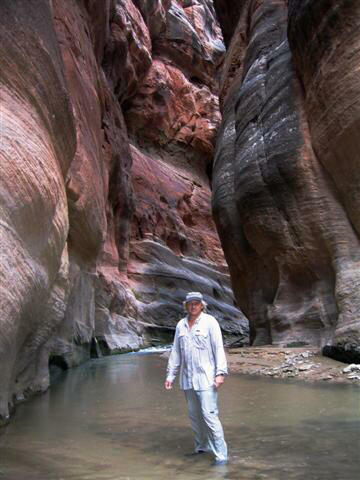
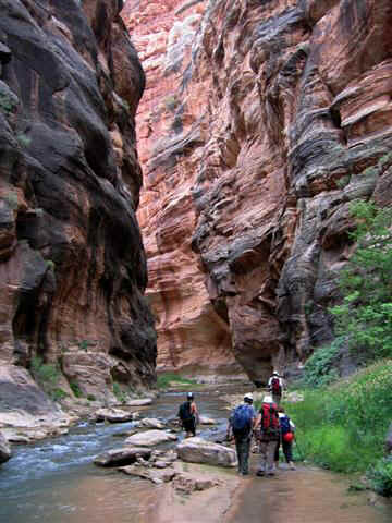
Everything was executed perfectly to plan. Josh's two sisters even agreed to drive the two top cars back to his house in Hurrikhan to save us even more time. Thanks ladies! We started our journey at the fresh early hour of 10:30AM and started hiking. We had a bunch of noobs with us, for 3-5 people in our group of 9, I think this was their first canyon. Even the approach hike was amazing, huge walls, pretty flowers, huge potholes, wow! We made good time through the main canyon, it got too narrow and dark after a bit, so I put the camera away and just enjoyed the canyon. Once we got lower in we finally started hitting flowing water and the canyon bumped up a couple notches. For some reason water just makes it more fun! I even dropped my GoPro in one of the deeper 6 footish pools and happily dove for it. Water wasn't really that cold at all, no one had wetsuits and most were a little chilly but nothing serious.
So we got to the bottom and the water coming out of the wall is warm. This canyon is full of surprises. We exit the canyon just before the Powell plate (we didnt go down to see it) and turn left up the river. Wow again! This canyon is seriously amazing! I wish I had gotten pictures but my "waterproof" camera somehow got water in the card section and was giving me a read error. And I couldn't get it dry enough to work again. But it is seriously an amazing canyon. there are amazing cliffs and even more fun traveling through the pools and sand and eddies. I was in heaven. We climbed up a neat 8 footish waterfall and the canyon just continued to impress us. Eventually we got high enough to where it seemed feasible to start taking one of these drainages out. We did stop and consider what I believe to be called Iceaxes's "French Canyon" http://www.bogley.com/forum/showthre...l=1#post316811 but I'm not sure since I can't find any info on it. But it was still a mile from the car and we decided after a careful vote and consideration to keep going upriver. I was convinced it was the right choice at the time. I saw a myriad of footprints (even dog prints) going upstream and none in this drainage. So we kept going up up up, where we eventually saw the drainage we wanted. I was extremely skeptical of this one also since it only had cow footprints and I figured others, who are more experienced, would have taken it if it was the right one. There were only a couple sets of cow tracks going up it and down.
So we followed the overgrown bushy cow trail. We figured the cows must know a way out of this place and the drainage looked huge on the map and dropped us off less than 1/4 mile from the cars. LETS DO IT! The trail got worse and worse. The cows were obviously not very tall, so we had to hunch down and crawl for most spots. I even had to take my backpack off because it kept getting hooked on branches. Another funny thing about cows. Apparently they are impervious to stinging nettles. Crawling on our hands and knees through thick underbrush and stinging nettles was not the best, haha. But whatever, we just experienced so many amazing sites the group was still in good spirits. Then the cow trail stopped.
That's right the exit got too steep, the cows gave up and went back. We could now see the top of the gorge and our exit. The cliff looked steep but not that bad, plus we had already gone a mile up it, it seemed foolish to turn back and find another drainage. Who even knew if there was a better one? We are now the first humans to try and go up this cliff. On the map things look so easy, but then you get down there and it's shit. So we started up the scramble exit. This cliff is literally falling apart. Everything you touch either crumbles to dust or falls down on the person below you. It was extremely dangerous and scary honestly. We had 3 "good" climbers in the group. I count myself as one of those but I should point out that the other 2 guys did stuff I would never attempt so maybe I should change that to "2 good climbers and one mediocre climber" hehe. I'm cool being exposed But when the rock is crumbly even I lose a bit of my nerve. Not having secure holds is definitely my achilles heel. It was immediately obvious none of the rest of group was comfortable traveling this. So we would find a secure tree and bust out the ropes. We would have the 3 of us scattered at 50 foot intervals and help the newer people up. Then it became even more insane. This was a 60% incline but covered with that crumbly moss and dirt. Neither myself or Josh could get up it and perhaps we are doomed. No way man! Somehow 150 pound Rick is able to scurry up it, grabbing on to dead branches and finding traction where our 200+ pound bodies cannot. He literally saved us from camping out by this maneuver. After several attempts we are finally able to toss him the rope. He hooks it to a tree just as the sun is setting. Besides us 3, no one can even climb this 40 foot slide, even assisted by a rope. We have them put their harnesses back on, attach them to the rope and pull them out with brute force.
The sun has now set, we bust out our headlamps and climb the remaining section to the cars. It wasn't bad at all once we got up that last obstacle and we even found a social trail to follow. But we were so exhausted from hauling the noobs up on ropes, it really took it's toll. I was actually fearing this would be my first forced bivvy and the stress probably wore me out too. But we made it to the cars at 10pm. Victory. I had then had one more obstacle to endure. We get back into Saint George at midnight. One of the noob's girlfriend yelled and screamed and cursed us out good, I guess she even called SAR on us worried sick. It was a perfect end to an evening though, nothing could bring me down after such an amazing adventure!
Here are some pics, I'll edit this thread in a bit with some video as well. I caught an epic fall from one of the noobs on film (into a pool of murky water). It just so happens this is the same fall he did in Orderville a year ago. I should really toss both vids up so you can appreciate the irony. It is now referred to as the "hand of victory".
VIDEO AND MORE PICS PAGE 2!
Your safety is not my responsibility.
-
06-11-2012 04:45 PM # ADS
-
06-11-2012, 05:03 PM #2
I consider down Misery Canyon, up through The Barricks, and out French Canyon to be one of the best routes in/near Zion..... the hike out of French is a piece of cake.
Heck, why do you think we call it French Canyon?!? It was named in honor of the French military for being an "easy retreat" (from The Barricks).
Route information for Misery/Barricks/French can be found here:
http://climb-utah.com/Zion/misery1.htm
Look near the bottom of the page under the section titled "Optional Local Route".
-
06-11-2012, 05:26 PM #3Bogley BigShot


- Join Date
- Oct 2005
- Location
- Just a few miles from Zion National Park
- Posts
- 8,456
Snake! Great pictures and trip report!
It was missing the Fat men though!
-
Post Thanks / Like - 2 Likes
-
06-11-2012, 05:55 PM #4
 nice TR! My buddy and I ended up going to North Wash instead of Zion since the temps were lower than norm and there was some decent wind to keep you cool and keep the bugs at bay. We'll have to hook up for some canyons soon!
-
Post Thanks / Like - 1 Likes
 Deathcricket liked this post
-
06-11-2012, 07:03 PM #5Ahhh ok! next time then. I haven't done rock canyon either and now I see you marked some petroglyphs which I also didn't see. Very interesting! So for sure I need to go back then. I think the finger we went up is marked by the "10" on your rock canyon map. I'll have to compare but it looks like we parked near your 1st campsite markage or maybe around the numbers "5380". I guess instead of consulting google earth I just need to get your "pro" beta instead next time. Cause that canyon was a disaster, haha.
 Originally Posted by Iceaxe
 Your safety is not my responsibility.
-
06-11-2012, 07:34 PM #6
Good stuff! Thanks for sharing
-
06-11-2012, 08:19 PM #7
 Great trip report. Sounds epic. Nothing like being cursed out by the girl friend!!! There are more than a couple of buddies who I have dodged on taking them canyoneering because I am honestly afraid of how their wives might react if they came home injured.
Ken
-
06-11-2012, 08:38 PM #8If you set up the shuttle I'd love to do it again. Sitting up the shuttle sucks if you are not a local because the shuttle has to be setup the day before. Originally Posted by Deathcricket
-
Post Thanks / Like - 2 Likes
-
06-12-2012, 05:58 AM #9Bogley BigShot
- Join Date
- May 2007
- Location
- We're all here, because we ain't all there.
- Posts
- 19,424
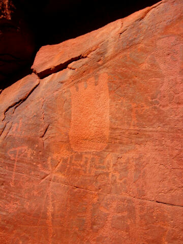
The petroglyph panel is not to be missed, very nice.
If going in from the coral pink side, to rock... it gets very sandy this time of year. I'd recommend a couple atv's. driving the second one to the bottom of the road, puts you within a couple hundred yards of the exit for rock.
-
06-12-2012, 07:01 AM #10Looking forward to the videos! Sounds like it was quite the trip. Originally Posted by Deathcricket
-
06-12-2012, 07:25 AM #11 Nicely done!
Life is Good
-
06-12-2012, 07:26 AM #12
- Gavin
-
06-12-2012, 08:42 AM #13A crappy picture because it was in the direct sunlight when we hit it.... but here is part of the panel... looks like a bear track. Originally Posted by oldno7
-
06-12-2012, 09:05 AM #14
__
-
06-12-2012, 09:31 AM #15I'm pretty sure we passed his French Canyon exit and took the next "major finger" up. I've been doing research after the fact and that pic posted here http://www.bogley.com/forum/showthre...l=1#post316811 looks exactly like the drainage minus the grass from a couple flash floods. We left Hurrikhan at 5:45AM to set up the shuttle the day of. It was like an hour 20 minute drive. It was pretty far, but IMO it's still the better exit. Provided you don't take the drainage we did and almost kill a bunch of noobs. That canyon is gorgeous! I think Iceaxe is right, in my limited experience it's one of the most scenic routes I've done so far. Originally Posted by BW123
But we were able to complete the route from 10:30am - 10:00pm. I think minus the horrid exit which was our fault, 7:30ish is reasonable, and a stronger group could finish by 5ish. We took a lot of "swim breaks" and went very to pretty slow, took a nap by the river, etc.Your safety is not my responsibility.
-
06-12-2012, 09:32 AM #16I'm being serious.... I really like the route and French Canyon is an easy escape (IMHO). But I do agree.... the 3 hour shuttle kinda sucks (we always set it up the night before). And speaking of sucks... baking in the heat on the standard hike back over Checkerboard Mesa kinda sucks and also deprives you of the nice stroll through the Barracks, which I enjoy. Originally Posted by BW123
Looks like you didn't read correctly... If you notice these guys set up basically the exact same shuttle I suggest, they just came out a different exit. All I'm telling them is if they do it again exit out French. I've been in the canyon they came out and it blows... if they had of picked the correct exit they would have had an easier day. Originally Posted by BW123
-
06-12-2012, 09:36 AM #17
For those playing along at home that don't know.... The Barrack's is pretty much like the best part of the Zion Narrows, but without any people. I've been into The Barracks a dozen times and only encountered anther group (of two hikers) once. I think it's a cool place... YMMV...
-
06-12-2012, 09:51 AM #18
__
-
06-12-2012, 11:32 AM #19I think we should be able to claim some type of historic right-of-way... after all, that's the way Powell went. Originally Posted by BW123
-
06-12-2012, 02:13 PM #20
I enjoyed your TR and story. That was an awesome adventure.


 Reply With Quote


Similar Threads
-
[Conditions] Subway/Misery
By noncuratlex in forum CanyoneeringReplies: 12Last Post: 05-16-2011, 04:44 PM -
Fat Mans Misery
By Pubalz in forum CanyoneeringReplies: 5Last Post: 04-06-2010, 04:07 PM -
Fat Mans Misery
By Bo_Beck in forum CanyoneeringReplies: 18Last Post: 03-19-2009, 06:39 PM -
misery conditions
By goofball in forum CanyoneeringReplies: 3Last Post: 09-15-2008, 12:12 PM -
Fat Man's Misery
By jstheman1 in forum CanyoneeringReplies: 1Last Post: 09-13-2007, 06:28 PM
Visitors found this page by searching for:
Outdoor Forum

