

Results 1 to 12 of 12
Thread: Granary Canyon
-
04-04-2012, 12:37 PM #1
Granary Canyon
One month after our experience getting an injured group member out of Granary Canyon in Moab, we returned to the canyon to finish what we had started. After a little confusion with rides, and an unfortunate mechanical problem with Bryan's car we made it to Moab at around 8:30 p.m. on Friday night to find that our campground from the previous trip was occupied. This particular campground was one we had chosen to go back to because when your driving through this kind of terrain at night, you can't see anything but the road, so when you wake up on this outcrop with 400' cliffs on 3 sides of you and the sun rising over the La Sal Mountains, It's pretty cool. We retreated back up the road to a sandy little nook and set up camp. We got on the road the next morning bound for Jug Handle Arch where would leave the shuttle car, at about 9 a.m. Jug Handle Arch is located about 14 miles down Potash Road in Moab, along the climbing mecca 'Wall street'.
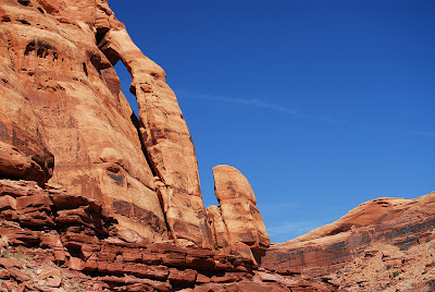
I led the group on a bit of a misadventure when I realized my gps wouldn't recognize the format of the coordinates I had, and was therefore trying to just use a map. We were hiking back towards the head of the canyon, which we passed (my fault), when we noticed another group of canyoneers down inside the canyon. I asked them what route they were doing and they told us they were doing the route with the 'onion' rappel, which turned out to not be true (no thanks to ajroadtrips.... again), but I think everyone was getting eager to get in the canyon, so we dropped in off a little tree right behind the other group. From the little tree where we dropped in, we could see the scree pile and the spot where Steve broke his ankles, Katie and I got a kick out of how far we made it into the canyon before we had to turn back (about 100 yards). The canyon was enjoyable, a few big rappels, and a few good obstacles requiring some climbing moves, but no real downclimbing or stemming.

There were some of the nastiest looking pools of water in the canyon on this trip.
.jpg)
.jpg)
At the top of a 70' rappel Dakota had his phone on his lap and forgot about it, when he stood up it went flying over the edge, bouncing off the walls and slamming into the wet sand at the bottom. A member of the other group picked it up and, to our amazement, informed it was still working. Down from this a little ways the canyon widened out quite a bit and the other group exited and headed back to their car. We soon came around a corner to find the canyon deepening dramatically.
.jpg)
After this rappel there wasn't any vertical obstacles until the exit rappel. It was just a lot of boulders for a little ways and then a very sandy hike. We came around another corner to see we were on the top of these HUGE 500' wingate cliffs overlooking the Colorado River. We searched a little bit for an area where we could rappel with a 200' rope. We found a place that had a 60' rappel and then another 120' rappel to the bottom. My phone was dead by this point, so I dont have any pictures, I will add them when I get some from other members of the group. After the final rappel we navigated around huge boulders for what seemed like close to an hour and then Cody, who sprinted from the bottom of the rappel to the car, met us to shuttle the group back to the Subaru at the top. We piled into the back of his Mazda with 4 people in the back seats and backpacks and gear on our laps reaching the ceiling of the car. We made it to the junction of US 191 and US 313 and Cody's car was having some serious problems. We pulled over with the hood up for a few minutes when an extremely nice couple from Bountiful pulled over and offered me and Bryan a ride back to the Subaru. We had parked the Forester at the end of a fairly aggressive 4WD trail and I did all but beg the couple to turn around and let us walk to the car in fear that they would damage their Subaru Outback being such good Samaritans. They however, took us right to the end of the trail with no problems. We made it back to Moab, met with Cody and Daina at Jax and enjoyed a burger. Because we didn't really want to drive back to our campground and we wanted a shower, we took a little advice from my cousin Kyle and booked a room at the Lazy Lizard Hostel.


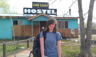

All I have to say about the Lazy Lizard is that it was awesome! One of the best nights sleep I have ever had.
To save time I just copied this post from my blog:
http://neildjohnson.blogspot.com/201...revisited.html"Without the possibility of death, adventure is not possible" --Reinhold Messner
-
04-04-2012 12:37 PM # ADS
-
04-04-2012, 01:40 PM #2Content Provider Emeritus


- Join Date
- Feb 2005
- Location
- Quiet and charming: Mount Carmel
- Posts
- 7,158
Sweet! Good to see you gettin at it after the earlier misadventure.
Uh, nothing like blaming your tools for your own shortcomings. Didn't we cover this last time? Might want to learn how to use the tools before wandering off into the wild? Originally Posted by ndonaldj
Those would be Navajo Sandstone cliffs in that area, though they look kinda like Wingate. I'm kinda confused here - were you using Shane's beta, and rapped near Jughandle? Otherwise, bravo getting past 500' cliffs with 1 x 60' + 1 x 120'!!! Originally Posted by ndonaldj
Tom


-
04-04-2012, 01:47 PM #3
Yes Tom, We have gone over this. And I THOUGHT I had figured it out. But obviously not. As soon as I broke out the map though we were fine. I'm about ready to give up on gps all together.
Thank you for the correction, I honestly don't know the difference between Navajo Sandstone and Wingate. I'm going to go look it up now.
We used a combination of Shanes beta and Ryans beta. We started in "upper granary" But continued down to Jughandle. And if you follow the ridge on top of the 500' cliffs untill almost where it turns to the left, there is a big boulder that has been rigged. Its a sequence of two rappels, one about 60-70' the other about 120', so we got down fine using only the 200' and a pull cord."Without the possibility of death, adventure is not possible" --Reinhold Messner
-
04-04-2012, 02:05 PM #4Content Provider Emeritus
- Join Date
- Feb 2005
- Location
- Quiet and charming: Mount Carmel
- Posts
- 7,158
Awesome. Is that spot marked on Shane's beta? Originally Posted by ndonaldj

T
-
04-04-2012, 02:07 PM #5
No, his beta only refers to a 195' rappel from a tree.
"Without the possibility of death, adventure is not possible" --Reinhold Messner
-
04-04-2012, 03:27 PM #6I my opinion this is ALWAYS a recipe for disaster. The number of SAR's and bivy's this has been responsible for is amazing. I suggest you pick ONE beta source for a particular route and use it for that route. It's nice to read the other beta so you don't get caught by surprise, but while on the trip I suggest everyone use only one source and the corresponding map. Originally Posted by ndonaldj
Anyhoo.... I'm still a little confused Did you do the Onion rappel? Because that is part of the Granary Route, its actually the best part.
-
04-04-2012, 03:31 PM #7 Originally Posted by ratagonia
Originally Posted by ndonaldj
Yes, the final 195' rappel anchor is marked with a yellow diamond on my map (as all my GPS waypoints are) and a GPS waypoint is supplied in the route description.
There is also a written description of how to find the final anchor for those without a GPS.
-
04-04-2012, 04:01 PM #8
I don't see anything wrong with using two sources of information to get to the same destination. We knew the two routes met in the middle, so we prepared for both.
Let me explain; Ryan's route does NOT go through the section of canyon that has the onion, (the other group we met in the canyon was under the impression it did, as were we the first time we did the canyon), Instead it takes you down a branch that is a lot more mellow, we had a few people end up going that had never been on rope before so it worked out great. The two routes converge towards the end of Shane's route, this is also one of the areas Ryan gives in his beta as an exit. Right at this point is where one of the pictures was taken of my wife next to the guy with glasses standing on a little overhang in front of a pretty deep section of canyon. This was the last rap before the exit by Jughandle.
The tree was marked on the map, but I don't think the boulder was. Not that it REALLY matters."Without the possibility of death, adventure is not possible" --Reinhold Messner
-
04-04-2012, 04:39 PM #9So long as you have a good understanding of where the routes differ its not a problem.... its when canyoneers don't that they get into trouble. This was a bit of a problem with Heaps when I first published it as all beta before mine detailed the Gunsight Entrance and when I first made the Phantom Valley entrance available it caused some confusion for some doing the canyon. The biggest problem was not getting lost, but that the obstacles didn't match what canyoneers were encountering/expecting, which is very disconcerting in a big dog like Heaps. Originally Posted by ndonaldj
I'm not saying one source is better than anther, I just make the suggestion to simplify everything, including your route and beta. In Granary for example, Ryan's route and my route are really not the same route, which are both a mix and match of the route guided by Deserthighlights, who popularized the canyon. Also, my waypoints and maps are in a different coordinate system than Ryan's. So if actually using both systems you have to carry two complete sets of maps and route descriptions.
As I said... the mixing and matching of route descriptions has resulted in more than one SAR and forced bivy.
-
04-05-2012, 07:50 AM #10At the last rap when you look toward the Colorado were you left or right of the tree that Shane's beta describes? Originally Posted by ndonaldj
-
04-05-2012, 08:43 AM #11
I believe we were on the right. Someone in our group spotted the boulder so we went strait to it, we didn't even look at the tree.
"Without the possibility of death, adventure is not possible" --Reinhold Messner
-
04-05-2012, 01:21 PM #12
Interesting, thanks.
Mark


 Reply With Quote


Similar Threads
-
[Trip Report] Granary Canyon 2.25.2012
By ndonaldj in forum CanyoneeringReplies: 20Last Post: 03-15-2012, 09:41 PM -
[Conditions] Granary Canyon Conditions?
By ndonaldj in forum CanyoneeringReplies: 5Last Post: 02-21-2012, 01:40 PM -
[Beta] Granary Canyon
By peakbaggers in forum CanyoneeringReplies: 1Last Post: 11-18-2010, 04:56 AM -
TR: Granary Canyon
By jumar in forum CanyoneeringReplies: 1Last Post: 05-25-2009, 07:53 PM -
Granary Canyon?
By moab mark in forum CanyoneeringReplies: 36Last Post: 11-27-2007, 04:11 PM
Visitors found this page by searching for:
Outdoor Forum

