

Results 1 to 16 of 16
Thread: San Rafael Reef Rock Art
-
03-28-2012, 08:37 AM #1
San Rafael Reef Rock Art
Yep--another trip to the San Rafael Reef, and my fifth since Christmas. In typical fashion, after my last trip there I learned of some rock art in the same area that I wasn't aware of at the time. A very knowledgeable friend read my last blog post and generously offered up some waypoints to visit the next time I'm in the area. With my wife being out of town this weekend I didn't want to spend it lounging around the house, so Michael and Bradley and I set out on an overnighter to visit some of this rock art. The low temperature was forecast to be 46
-
Post Thanks / Like - 2 Likes
-
03-28-2012 08:37 AM # ADS
-
03-28-2012, 10:17 AM #2

Since you were at Zero-G... I'm not sure if you know about them or not.... but there are some really good Picto's were Straight Wash cuts through the reef. They are located along the north wall. Many are hidden behind large bushes. Just walk the base of the north wall where it cuts through the reef and you will find several good panels.
-
03-28-2012, 10:30 AM #3
I used your beta a few years ago when I hiked to the big pool in the bottom of Eardley, and I found the petroglyph panel with the big snake in Straight Wash, but I completely missed the pictographs when I was there then. I'd planned on checking them out on this trip but we ran out of time. I also learned of some other rock art in Straight Wash that's not near the main set of petroglyphs and pictographs. Seriously thinking about camping there this weekend and checking them out, along with a nice climb to the top of the Reef north of Straight Wash.
-
03-28-2012, 10:34 AM #4
Hiking up Zero-G above the technical section is interesting, at least as far as I've hiked. Your kids will like the small arches at the top of the tech section.
Last time I was in Straight Wash I looked for rock art behind the bushes and found some I'd missed on earlier trips.
-
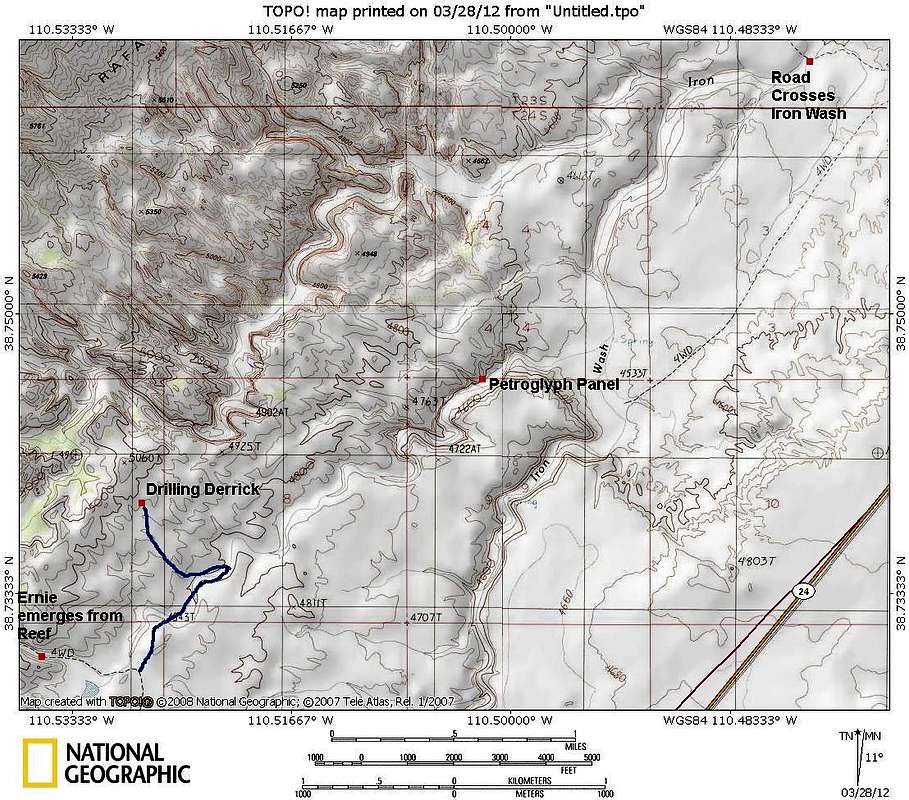
03-28-2012, 11:04 AM #5There is an even better panel in the area (though petroplyphs). If you park where the road crosses Iron Wash on the way to Eardly or Zero G and walk up Iron Wash to the Ernie/Iron Confluence and then just up the Ernie Drainage, there is a very good panel of petroglyphs. Perhaps the best panel I have seen in the east side of the Swell area.but there are some really good Picto's were Straight Wash cuts through the reef. They are located along the north wall. Many are hidden behind large bushes. Just walk the base of the north wall where it cuts through the reef and you will find several good panels.Utah is a very special and unique place. There is no where else like it on earth. Please take care of it and keep the remaining wild areas in pristine condition. The world will be a better place if you do.
-
03-28-2012, 03:11 PM #6That's a long walk! you can drive to the mouth of Ernie if you enter at mile marker 141.7.
 Originally Posted by Scott P

-
03-28-2012, 04:52 PM #7No, you are thinking the mouth of Ernie where to emerges from the Reef. This is actually far below that. This one is far to the northeast of that and quite a ways from the Reef. It's in a very shallow canyon right before the Ernie drainage meets Iron Wash. It's less than a 45 minute walk from where the road to the mouth of Eardly/Zero G crosses Iron Wash. It would be a longer walk from where you are talking about. It might be about the same distance if you drove to near the old derrick and walked down from there, but it would be a longer drive than coming in from Iron and would take just as long to walk.That's a long walk! you can drive to the mouth of Ernie if you enter at mile marker 141.7.Utah is a very special and unique place. There is no where else like it on earth. Please take care of it and keep the remaining wild areas in pristine condition. The world will be a better place if you do.
-
03-28-2012, 05:11 PM #8OK, I gotcha. Originally Posted by Scott P
I assume these petro's are one the north wall?
I was confused because there is also some petroglyphs where Ernie exits the reef.
-
03-28-2012, 05:14 PM #9
Here is a map:
 Utah is a very special and unique place. There is no where else like it on earth. Please take care of it and keep the remaining wild areas in pristine condition. The world will be a better place if you do.
-
03-28-2012, 05:17 PM #10
The map does show a 4wd road getting closer to the panel, but I haven't ever tried that road. You could get closer to the panel by walking from the highway too, but you would need to route-find and find the correct place to park along the highway. It's probably easier to just walk from Iron Wash and takes less than 45 minutes.
Either way, the panel is well worth getting to and the best I've seen in the area.Utah is a very special and unique place. There is no where else like it on earth. Please take care of it and keep the remaining wild areas in pristine condition. The world will be a better place if you do.
-
03-29-2012, 08:32 AM #11
Hi Udink,
Interesting report and nice pictures. I like the Rey Lloyd Hatt site pictographs.
That's nice to share these moments in the wilderness with your boys and your dog, that will also make for good memories.
Philippe
-
03-29-2012, 08:35 AM #12
Thanks Scott
FYI: If I remeber correctly, the referenced 4wd road shown on the map was closed by the BLM a few years back and has been recovered by nature.
-
03-29-2012, 09:04 AM #13Hi Scott, Originally Posted by Scott P
Thank you for sharing this location. Have you a picture of this nice panel, I've never heard about it.
Philippe
-
03-29-2012, 12:12 PM #14
sweet !!!!
-
04-04-2012, 02:22 PM #15
Wonderful TR and pictures!

Thx for sharing!
-
04-05-2012, 07:33 AM #16
Very cool!


 Reply With Quote


Similar Threads
-
[Trip Report] Old Woman Wash, San Rafael Reef
By Udink in forum Rock Art & RuinsReplies: 13Last Post: 02-25-2012, 12:22 PM -
[Trip Report] Ernie Benchmark - San Rafael Reef
By Udink in forum Hiking, Scrambling & Peak BaggingReplies: 14Last Post: 01-12-2012, 07:34 AM -
[Trip Report] Day of the San Rafael Reef
By coinslab in forum Rock Art & RuinsReplies: 2Last Post: 10-20-2009, 06:05 PM -
Cable Canyon & San Rafael Swell / Reef conditions?
By heliski2 in forum CanyoneeringReplies: 8Last Post: 09-18-2009, 07:15 AM -
[Trip Report] Behind the Reef Trail ATV Video - San Rafael Swell
By RedMan in forum Offroad 4x4, Side by Side and ATVReplies: 2Last Post: 01-12-2007, 10:30 PM
