

Results 1 to 8 of 8
Thread: Henry Mountains East
-
06-14-2011, 10:06 AM #1
Henry Mountains East
I'd been wanting to get out for a quick overnighter this past weekend, but nothing in the San Rafael Swell interested me. After reading Scott P's trip report from Crescent Creek, I started poking around that area in Google Earth and decided it would make for a nice couple of days. I ended up visiting Little Egypt on Friday evening and camped near Pysert's Hole. On Saturday, I checked out Crescent Creek and tried (unsuccessfully) getting to Bull Creek Pass. That afternoon I hiked up Leprechaun Canyon before heading home.
http://udink.org/geo/HenryMountainsEast.kmz
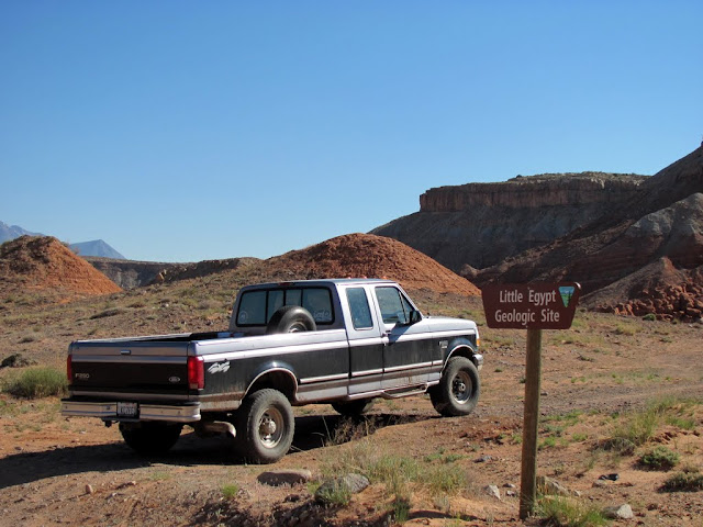
Little Egypt was small but interesting. One of the best formations was the also farthest from the road. I hiked a little under two miles and probably saw all there was to see there. Next I drove to some interesting-looking Morrison Formation hills. They'd looked awesome from above in Google Earth, but in person they weren't quite as cool. I drove toward my intended camp spot in Pysert's Hole, but one spot where the road followed the edge of the wash had been completely washed out more than a mile short of where I wanted to camp. The sun had already been down for quite some time and I didn't want to try finding somewhere else to camp in the dark, so I set up camp right there at the end of the road.
Little Egypt parking area
Little Egypt


Torrey blended in well at Little Egypt


Little Egypt with Mt. Hillers in the distance

Morrison Formation hills with Mt. Hillers behind


End of the road to Pysert's Hole

Camp near Pysert's Hole

I was disappointed not to get into Pysert's Hole, and early in the morning it was already pretty hot and I didn't want to make the boring hike to get to the good stuff in there. The bugs were really bad in the morning also, so I hurriedly packed up camp and hit the road looking for something else to do. I tried getting up Copper Creek to do some hiking, but the road was rough and faint and disappeared into the sagebrush before I got close enough to begin hiking. Instead, I checked out Crescent Creek. I'm sure I only saw a small fraction of what there is to see in Crescent Creek, but it was still a very interesting area. I hadn't originally planned on it, but after Crescent Creek I tried driving up into the Henry Mountains proper to Bull Creek Pass. As expected, I ran into some snow drifts less than a mile from the pass. The views from up there were great, and I only wish I'd have been able to peek off the west side toward the Capitol Reef area as well.
Inside a shallow adit in the South Fork of North Wash

Outhouse along Copper Creek

Disappearing road along Copper Creek

Stone cabin along Crescent Creek

Log cabin along Crescent Creek

Trail down into Crescent Creek

Bottom end of the Crescent Creek narrows

Crescent Creek narrows

Lecleed Spring turnoff

Crescent Creek above Lecleed Spring

Crescent Creek below Lecleed Spring

Mine workings and old bridge over Crescent Creek

Log bridge over Crescent Creek

Crescent Creek narrows

Road up Bromide Canyon

Climbing the road toward Bull Creek Pass

Panorama taken near the head of Butler Wash

Bull Mountain

Mt. Ellen
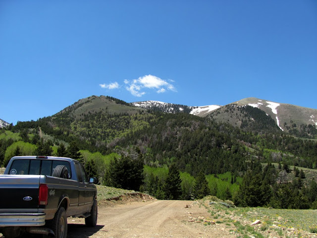
Getting into some snow drifts

This snow drift prevented me from going further

It was a stark contrast being stopped by snow drifts, then about an hour later being at the parking area at the bottom of Leprechaun Canyon with temps in the mid- to upper-80s. There was a vicious dog tied up (unattended) to a vehicle at the parking area that acted as though it wanted nothing more than to attack me and my dog. I was pissed that it was given a long enough lead that it could reach the road where people had to walk past to get into and out of the canyon. I passed a couple groups of canyoneers coming out of the canyon. I didn't quite make it to the bottom of the last rappel--there was a muddy puddle that I didn't want to walk through--but what I did see of the canyon was great. Someday I'll go back and do it from the top-down.
Parked at the lower end of Leprechaun Canyon

A fork in the canyon

Some light bushwhacking

Short narrows in the lower canyon


Snuffleupagus

Deeper into the canyon


Looking straight up


There are quite a few more photos here:
https://picasaweb.google.com/Dennis....yMountainsEast
Here's my blog entry with a bit more info:
http://udink.org/2011/06/13/henry-mountains-east/
-
06-14-2011 10:06 AM # ADS
-
06-14-2011, 10:22 AM #2
Very nice TR and pics. Can't believe someone tied their dog up and left them there. WTF.
-
06-14-2011, 11:21 AM #3
Nice write-up. I love your dog in in Little Egypt. Also, cool to see Crescent from this angle and pair it with Scott's earlier report.
That pool in Leprechaun is a lot smaller than just 3 weeks ago when I was there. Then it was really long and up to my waist... and definitely cold and muddy! Pic for reference:

<insert shivering emoticon>
- Jamal
-
06-14-2011, 12:29 PM #4
Coolness!

-
06-14-2011, 03:56 PM #5
Nice TR and pics.
-
06-14-2011, 08:02 PM #6
Very nice! That looks like a sweet area where you can get variety of terrain in one trip. Very sick. Love the photos and the write up!

-
06-15-2011, 05:02 AM #7
Good stuff Dennis, thank you for posting.
RP
-
06-16-2011, 07:49 AM #8
Nice pics! The Henry's look beautiful. And Leprechaun is a favorite stop of mine. The pool in the Subway section is new since last August.


 Reply With Quote


Similar Threads
-
[Trip Report] The Henry Mountains Revisited
By IntrepidXJ in forum Offroad 4x4, Side by Side and ATVReplies: 7Last Post: 09-15-2010, 07:42 AM -
[Trip Report] Laccolith Tour | Henry Mountains
By IntrepidXJ in forum Offroad 4x4, Side by Side and ATVReplies: 8Last Post: 06-17-2010, 07:10 AM -
Henry Mountains Bison?
By Don in forum Hunting & ShootingReplies: 2Last Post: 12-21-2009, 08:32 AM -
[Trip Report] NEEP TR - North East Fork of East Pasture 09/13/2009
By french_de in forum CanyoneeringReplies: 7Last Post: 09-17-2009, 12:47 PM -
Henry Mountains... what/where/when
By ExpUt in forum Offroad 4x4, Side by Side and ATVReplies: 4Last Post: 11-05-2007, 08:56 PM
