

Results 1 to 1 of 1
-
06-13-2011, 09:37 PM #1
Exposed Solo Ascent in Eastern Utah
I was looking to do a solo trip in early April of 2005. Climbing with partners is great, but sometimes you just need to get out and climb alone and have a place all to yourself. The Dinosaur area is always a good choice to be alone since I have never ever seen another hiker out there except for at Jones Hole and Harpers Corner. In spite of the fact that there are some great and very spectacular peaks out there they seem to be ignored. I wanted something that would be a challenge, but only class 3 or 4 since I would be alone.
I had been interested in the south face of Blue Mountain for a long time. I have driven past it several times, but had always put climbing it on the backburner. The face is really jagged and looks challenging, but I felt certain that I could find a route up there somewhere. Since I would be alone, I promised to keep it 4th class or easier, and even for any 4th class sections that I may find, I had a rope. I left Craig in the morning and since my printer wasn't working, I couldn't print out a map. No matter, the mountain is easy enough to see from the highway and I didn't think I would need one anyway.
I packed and drove towards the mountain, arriving and starting my climb at 11 AM. Since the mountain is not that long of a climb, time wasn't really a concern.


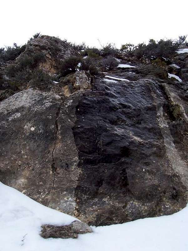
I actually parked back at Point 5844 because I didn't know the road went closer to the mountain. In my haste when packing I had left the climbing rope in the vehicle. I went north cross-country over many drainages and towards the white rock slabs (towards the right side of the above photo) between the huge white wall and the canyon to the east. They looked like a good challenge, but not more than 4th class. There were many rills and gullies to cross before arriving at the slabs. The slabs turned out to be more difficult than expected. Their angle was 50-70 degrees and quite challenging. It wasn't too difficult, but the higher I got, the scarier it became. I decided to angle over to the east while climbing up and hopefully get off the slabs. The route turned into a more difficult and exposed than expected, 4th and low-5th class with a few hundred feet of exposure. Scary. I shouldn't be here alone, and wished I had a rope and a partner. After a few scary moves, I could climb off the slabs and climb up to the Razor Ridge. I had wasted two hours on the slab. The rest of the route should be easier. I knew that the ridge would make a better descent route. The rest of the ridge was steep and straight forward to the cliff band. There was some scrambling, but nothing difficult or dangerous. I had passed a dead rattler along the way.


The cliff band appeared as it might have a break in it right near the ridge crest and I went to check it out. The break didn't go all the way through, but it appeared climbable. The cliff band did have a class-3 break, at least below, but a secondary cliff band immediately above this blocked the route. The route appeared to go, but was exposed. It was 3rd and 4th and 4th class below, but was capped by a 5.2-5.4 crux. The crux was highly exposed, and if one were to fall off, you would fall a long way before falling. I didn't expect that it would be so difficult and scary. I knew that I couldn't climb down it, but I also knew that if I followed the ridge crest from the summit of the mountain for far enough east after summiting, the mountain wasn't as steep. I started to climb up the crux, and it scared the piss out of me. It was more difficult than I expected and with high exposure, it was scary as heck (the Utah choice of words). When I neared the top, I set a rock loose and it crashed down the mountain. I nearly lost my grip and scraped the inside of my left arm and had smashed my left ankle against the wall. A sharp pain shot through my ankle, and I froze for a while panic-stricken. I finished quickly but shakily finished the final climb and panted while lying in the snow and rocks with my heart pounding. I wouldn't do that climb every again and without a rope, not in a million years! I noticed that my arm and ankle were bleeding, so I took out a handkerchief and wrapped it around a snowball and put it on my arm. It stung pretty badly. I was sitting now wondering what to do next. I was worried about my ankle. I was also concerned that I would be benighted before I got down the mountain, but there seemed to be some hollows in the cliff where I could spend a night if I had to. I had a lighter could build a fire and there was plenty of wood available. My ankle wasn't too bad. It was just cut and scraped and wasn't really injured or broken. It felt OK walk on. I was relieved. I continued my ascent. I accidentally left my hankie below, but I wasn't going to go after it. I noticed a chute to the west that looked like it went all the way through the cliff band without any problems. It was filled with snow, but appeared it would go. I had hoped I could use it as a descent, but if I had to turn back and climb back up if it didn't go, I would be benighted for sure.

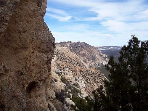
I continued my ascent to the summit and I was surprised to find just how flat the summit ridge was. I went over to the crest to the north, but the views were better from the rim. I had hoped to see off the north side. There was much post-holing. There are meadows, aspens, and pines all over the summit ridge instead of the barren rocks and desert-like vegititation below.

Now I had to get down. I really hope the chute would go. I climbed down to the chute and descended. It was much more difficult than expected, and hardly a walk in the park. The snow was waist-deep and since water drips over the and under the snow, the snow was covered in slippery ice. At one point I had to slide over the ice over a boulder and into deep snow.
At the bottom of the chute, the next order of business was to traverse back to the Razor Ridge which I ascended. It took a little back tracking, and some minor climbing, but it was less scary than the crux pitch I climbed up on the ascent. I was relieved when I reached the ridge. The rest of the route was just a very steep descent down the ridge with only a bit of scrambling. The rock fins at the end had to be bypassed, but this was cake compared to the route I went up. From above, I could see that a 4wd road would take me back to near where I parked the car. I followed the road back and reached the car not long before sunset. The trip had taken seven and a half hours, much longer than expected. Now that the route is lined out, it should take much less time.
The next day, the east summit of South Split Mountain was climbed.Utah is a very special and unique place. There is no where else like it on earth. Please take care of it and keep the remaining wild areas in pristine condition. The world will be a better place if you do.
-
06-13-2011 09:37 PM # ADS


 Reply With Quote
Similar Threads
-
[Trip Report] NF Big Pine Creek - Eastern Sierra
By goofball in forum Backpacking & CampingReplies: 7Last Post: 02-12-2021, 12:15 PM -
[Trip Report] TR: Solo Ascent of Sandtrhax (Yes, Ascent)
By Bzen in forum CanyoneeringReplies: 17Last Post: 09-01-2010, 10:29 AM -
[Trip Report] eastern sierra spring touring
By stefan in forum Skiing, Snowboard, XC and SnowshoeingReplies: 6Last Post: 08-10-2009, 08:58 PM -
Middle Eastern freaks out on an airplane
By Sombeech in forum General DiscussionReplies: 1Last Post: 12-17-2007, 07:26 AM -
My solo journey from Utah to Alaska
By tuckerdt in forum MotorcyclingReplies: 5Last Post: 09-25-2007, 06:34 PM
Visitors found this page by searching for:
Outdoor Forum
