

Results 1 to 6 of 6
-
05-02-2011, 09:46 AM #1
Road on the Western Side of the Green River that goes to an overlook?
I am headed down to the Green River Road and was wondering if any spurs go to an overlook of the Green. It is my understanding the road by Keg Knoll goes a certain distance than is closed because of wilderness study. Any recommendations would be greatly appreciated.
-
05-02-2011 09:46 AM # ADS
-
05-02-2011, 11:52 AM #2
If you have a high clearance 4wd you can see the green from the bull bottom road or the road near three canyon that dead ends across the trin alcove bend. There is also a very cool overlook off the first spur road a mile or two south of three canyon.
Keg knoll is not the place to see the green unless you plan on hiking out to the bowknot. The road has been washed out and you need to park a few hundred yards before the wsa boundary.
-
05-03-2011, 01:23 PM #3
I was out at the end of Keg Knoll road last week camping a night with my daughter. As Summit indicates, you have to hike a ways to get views of the river. We made it to Colonnade Arch and beyond, but turned around before reaching bowknot due to an approaching thunderstorm. Most of the views were of the canyon and cliffs with a bit of the river; very nice views well worth the walk. It is a walk on mostly slickrock with a very good chance of solitude.
The Keg Knoll Road is mostly very good. There is a little bit of rough passage over some slickrock in small washes near Keg Knoll, then quite a bit rougher the last 1/4 mile or so, exactly as Summit indicated in response to my inquiry a few weeks ago (thanks Summit for the good info!). I was able to make it out to the wide parking area a couple hundred yards short of the WSA in my Toyota RAV4 4WD. The last bit of road took some care, but I didn't scrape bottom anywhere. It would be easy to park short of the last rough spot and hike a little farther.
-
05-03-2011, 03:24 PM #4
We camped out there on Wednesday night before we headed into the Maze.
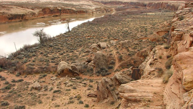
BullBottom-2008-3-28 085 (32) by Summit42, on Flickr

WolvertonOverLook-2008-3-28 by Summit42, on Flickr
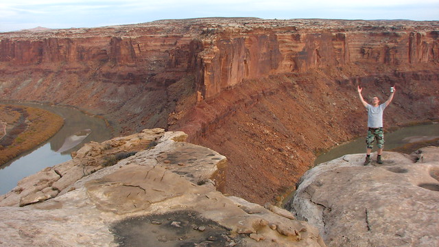
BowKnot-2007-11-10 (58) by Summit42, on Flickr
-
05-03-2011, 08:01 PM #5
Thanks so much for the insights. Wow, it looks like the road almost goes down to Bull Bottom. Great information!!! Should be a grand weekend. If anyone is in the area; look for a white land cruiser and join us:)
-
05-03-2011, 09:44 PM #6
Thanks, great info.


 Reply With Quote
Similar Threads
-
East Side Road Closure in Zion
By dbaxter in forum General DiscussionReplies: 0Last Post: 12-20-2010, 09:08 PM -
Flooded River Destroys Road In Minutes
By accadacca in forum General DiscussionReplies: 0Last Post: 07-01-2009, 08:39 AM -
Anyone from/know Green River, UT?
By Shan in forum General DiscussionReplies: 11Last Post: 04-29-2009, 11:52 AM -
road to halls creek overlook in capitool reef np
By goofball in forum General DiscussionReplies: 4Last Post: 11-20-2007, 08:13 PM
Visitors found this page by searching for:
Outdoor Forum
