

Results 1 to 20 of 25
-
04-26-2011, 03:45 PM #1
hi! and dark canyon help if you got it. (youngs-lean to?)
Hi all,
I'm new to this forum and pretty excited about it since ive been hiking escalante for years. I look forward to adding to the knowledge in whatever way I can!
Right now I'm planning a trip for the end of may and it looks like dark canyon is high on the list. We'll be doing 5-6 nights.
I've read about the woodenshoe-peavine loop but I'd rather see the depths of dark canyon. I'm also trying to put together a loop so I don't really want to just go down sundance and base camp. Ive heard a few people mention young's and lean to and this is intriguing. Does anyone have any beta on making a loop out of these? I'd be into hitting it from sundance or from the top of youngs, which I understand you can drive to. Anyone got directions for that drive?
Thanks in advance for any help you can give, and I'll be sure to file a trip report for this one...
-Andy
-
04-26-2011 03:45 PM # ADS
-
04-26-2011, 05:46 PM #2Bogley BigShot


- Join Date
- May 2007
- Location
- We're all here, because we ain't all there.
- Posts
- 19,424
Please take a seat, Denaliguide will be with you in a moment.......
-
04-27-2011, 12:38 AM #3you just cracked me up.
 Originally Posted by oldno7

 thanks for the props.
now to the original question.
i did a loop several years ago. it was in one of steve allen's books. i think it was canyoneering 2, "technical loop hike in southern utah". i did his described dark canyon loop in reverse. we came down the sundance trail, and went down canyon then before the river we went up and followed a terrace upriver, over hill and dale all the way to bowdie canyon. then we came back north and down lean-to canyon into dark canyon and up the sundance back to the car.
this is a good 5 to 6 day trip with some interesting route finding, ruins, rockart, and minimal exposure. not really a technical trip. just one spot where you crawl (literally on your hands and knees)along a short (15') 3' wide ledge. it does have some exposure but it's not really difficult.
i would recommend that you have good (meaning well above average) map reading skills, as well as experience routefinding in terrain that is trailless. it's a good crosscountry trek from bowdie back to lean-to and you want to be able to recognize when you hit the old airstrip before you drop into lean-to.
i really enjoyed this trip, hope you do to. if you want more info just pm me.But if I agreed with you, we would both be wrong.
-
04-27-2011, 06:02 AM #4
Youngs-Lean To is the prime loop in Dark Canyon. The Woodenshoe-Peavine Loop doesn't visit the best parts of Dark Canyon.
I would suggest not doing the Allen Loop mentioned above because the part of Bowdie it visits is a horrible bushwhack and not nearly as interesting as the parts of Bowdie not covered by the book. It also makes little sense to start at the Sundance Trail for the loop and to do Bowdie at the same time since it will cross several well-used roads on the north side of Dark.
I recommend starting on the north side of Dark for a loop. SA's directions are good into Youngs Canyon and Lean To, but there is an easier way into the lower end of Youngs. Both canyons are rugged, but worth it. Four days (three if you are in a hurry, but four is better since you will visit the best part of Dark) is good for the Youngs-Lean To Loop, but you can add a 5th day by going down Dark to the Colorado River. Bowdie Canyon is also excellent, but by far the best part of the canyon is below the confluence of the two forks. As mentioned, the part of Bowdie in Allen's book has become a bushwhack (unless it has been cleaned up by floods) and isn't anywhere near as scenic or interesting as the section below the confluence. [SA once told me that upper Bowdie used to not be as bad of a bushwhack, but became that way in more recent years].Utah is a very special and unique place. There is no where else like it on earth. Please take care of it and keep the remaining wild areas in pristine condition. The world will be a better place if you do.
-
04-27-2011, 10:17 AM #5
Thanks for the info guys! I'm going to take a peak at the SA book today, and probably have some questions later on for you all. Any ideas about the water situation in young's and lean-to? I'm really leaning towards the loop from the north side. I want to run into as few people as possible, and a long backcountry drive is fun too. Give the ol' fj60 a workout...
-
04-27-2011, 12:13 PM #6
Alright looks like down youngs and back up lean-to is the route! Seems like plenty of wate4 except up on the mesa and we can deal with that no problem. Next question is sweet Alice road. Has anyone driven that? Any ideas about how gnarly it is? Is there a local blm office that might know about conditions on it? And whats the best way to get to it - ut95 or beef basin? I'll be coming down through moab. Thanks again for all the help! I can't wait to hit the trail...
-
04-28-2011, 07:56 PM #7
Two years ago the Sweet Alice Road wasn't bad till you get down near Bowdie Cyn, 2wheel truck. There is one spot coming off Longs Point that stays drifted in for a long time, we had to dig thru a few trips back. Bowdie does have some nice ruins, pouroffs, etc. the thick stuff is about a mile from the river. We did a Fable Valley to Bowdie Cyn loop one year, but we floated the Colorado to get down to Bowdie, much easier than hiking the rim! There is a Trails Illustrated map of the area that is not bad.
-
04-29-2011, 12:04 PM #8
Sweet! I'll be hitting it with a lifted landcruiser so that sounds like no problem. We'll be heading into the top of young's so thats right near the top of bowdie as well. This truck is unstoppable in sand but i'll have a shovel with me anyway. We might day hike down into bowdie a bit-is there water anywhere near the top? Or is there even anything worth seeing up high? Anyway thanks for the info. Gonna find a local blm office and see what thy say too.
-
04-29-2011, 04:09 PM #9Yes, but near the rim, it's cow pie filled (or was).We might day hike down into bowdie a bit-is there water anywhere near the top?
There is nothing in Upper Bowdie worth the bushwhack it take to get there. Lower Bowdie is incredible, but required a backpack. Skip the upper forks and enter Bowdie below the confluence. That part is much more scenic and has good ruins, big waterfalls and huge crystal clear pools of water. The upper forks have a few ruins and a nice arch, but are no where near as scenic as the lower end, but the forks are choked with brush. If you just must do the upper forks anyway, come in the north, but the ruins are in the south fork just abve the confluence. Lower Bowdie has better ruins as well.Or is there even anything worth seeing up high?
If you only want to go on a dayhike, visit Fable Valley instead of upper Bowdie.
If you enter at the top of Youngs, there are impassible (without ropes farther down). You have to climb all the way out of the canyon and back in. Steve Allen describes the route pretty good in Canyoneering II. There is another route slightly easier route into Dark right near the confluence of Dark and Youngs.We'll be heading into the top of young'sUtah is a very special and unique place. There is no where else like it on earth. Please take care of it and keep the remaining wild areas in pristine condition. The world will be a better place if you do.
-
04-30-2011, 01:16 PM #10
Scott, SA makes it sound like there's only one big fall that you need to go out of the canyon to get around. I'm not in a big rush on this trip so we'll probably just head into young's at the top and take our time exploring it. Sounds like there's plenty of water especially below that big drop. Just in case though can you describe the other route a bit?
I'll definitely look into Fable - thanks for the tip!
-
04-30-2011, 06:38 PM #11
Definitely do Fable Valley, The Fortress is one of the best known unknown ruins. The valley around it is littered with potshards, there are granaries, pictos, etc. Its a great day hike. Good water at Fable Spr where Gypsum Cyn comes in. Ruins on the rock towers. Can only get down the road from Sweet Alice about half mile. A few teasers:
-
Post Thanks / Like - 1 Likes
 oldno7 liked this post
-
04-30-2011, 06:46 PM #12
The upper Northeasterly Fork of Bowdie is pretty nice, some decent single dwelling (not visited much) and some hugh pouroffs. There is a hug ruin, kivas, etc below the main fork. Its a long dayhike but worth it. There is a shorter route directly to the large ruin.
4X4 road down here. WAter in Bowdie above the main fork is sparse but there. Some Bowdie teasers:
-
Post Thanks / Like - 1 Likes
oldno7 liked this post
-
05-01-2011, 07:21 PM #13
Awesome photos, Bobb. Fable Valley is certainly one of the prime locations for ruins down there.
Is this from the route dropping into Bowdie, north side on the road/route towards Palmer Canyon or did you come in the shortcut on the south side of the canyon just below the confluence?There is a shorter route directly to the large ruin.
4X4 road down here.
================================================== ================================================== ================================
May 1995 we went down the NE Fork of Bowdie to explore it, but the people I were with weren't that motivated and we turned back at the giant pouroff near Point 6005.
My wife and I returned in May 2000. We went down the South Fork from the head and found it to be a bad bushwhack (though I wonder if the huge floods in 2006 reamed it out) until around the confluence. There were some ruins in the South Fork just before the confluence, but (especially since we wore shorts), I wouldn't recommend that part of the canyon at all.
The part below the confluence of the two forks was awesome and we explored to the river finding many ruins, pictographs, waterfalls and beautiful pools along the way. I assume the ruin you are speaking of that is the long day hike is the one above the first pool/waterfall below the confluence? Looks familiar. You could certainly get to that ruin and back in a day, but it would be preferable to save more time to explore the canyon to the Colorado River. The ruin is right where the canyon starts to get really good.
I wouldn't mind hearing of the location of the one in the "Northeasterly Fork" if you ever want to trade some beta/info for it. We missed that one. After exploring Lower Bowdie in 2000, we went out the North Fork, exiting just before Point 6005 where we turned back on the previous trip. Bushwhacking wise, the North Fork was no where near as bad as the South Fork, but what we saw of it wasn't as cool as Lower Bowdie (though we missed the ruin you speak of in the first sentence of your post). It's nice to know that ruin is in there. After seeing Lower Bowdie and the bushwhack experience, I had almost written off going back to Upper Bowdie.
Once again, those Fable Valley photos are awesome. I'll have to take the kids down there. Gypsum is one of the best non-slot canyons on the CP, IMHO.
Yes, one series of falls.Scott, SA makes it sound like there's only one big fall that you need to go out of the canyon to get around.
Not a bad idea.I'm not in a big rush on this trip so we'll probably just head into young's at the top and take our time exploring it.
Yes there is and the waterfalls in lower Youngs are some of the most beautiful I have seen. Awesome pools too. IMHO, the final huge pool with a waterfall spiling into it is perhaps the most spectacular site in the Dark Canyon complex. Don't miss the petroglyphs near the mouth of Youngs either.Sounds like there's plenty of water especially below that big drop.
I'll send a map (if I forget remind me), but the route marked on the map will be approximate.Just in case though can you describe the other route a bit?Utah is a very special and unique place. There is no where else like it on earth. Please take care of it and keep the remaining wild areas in pristine condition. The world will be a better place if you do.
-
05-02-2011, 12:17 AM #14
Nice pics! Thanks for posting those. Def gonna hit up fable now as well. Is the fortress hard to find?
Scott, that map would be great! Let me know if its easier to just send it to my email.
Thanks so much for all the help. So stoked to get out there...
-
05-02-2011, 08:48 PM #15
Turnoff is about: 37
-
05-03-2011, 03:44 PM #16
Nice bobb! Thank you. Just thinking... You dont have any hints about finding Lewis lodge do you? Feel free to pm me if you want. I know its somewhere near bears ears pass but I can't find much more. Thinking I want to hit that too...
-
05-04-2011, 10:39 PM #17
-
05-05-2011, 01:14 PM #18
Gonna be down there in three weeks. Looking forward to hearing about your trip though!
-
05-06-2011, 09:11 AM #19yeah be sure to post a TR. I'm interested in the same trip! I find that I'm starting to become more and more interested in these multi-day backpack trips to out of the way ruins. Originally Posted by Don
beefcake. BEEFCAKE!
-
05-12-2011, 06:47 PM #20
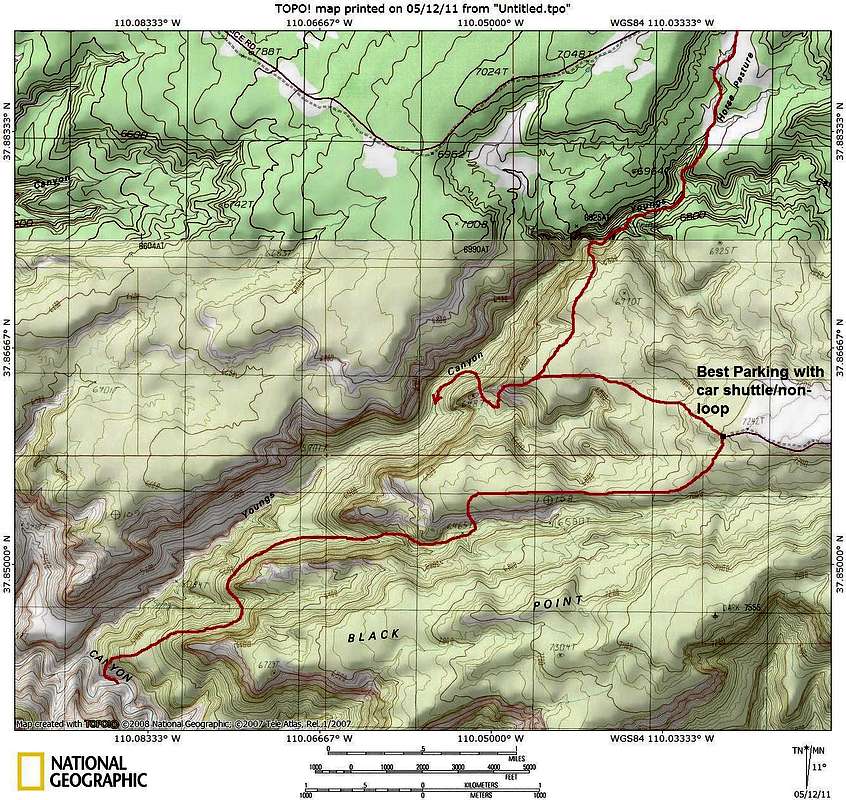
Above is a map of Youngs Canyon. Take it with a grain of salt though since the routes marked are in the approximate rather than exact locations.Utah is a very special and unique place. There is no where else like it on earth. Please take care of it and keep the remaining wild areas in pristine condition. The world will be a better place if you do.

 Reply With Quote


Similar Threads
-
Dark Canyon
By kris in forum Hiking, Scrambling & Peak BaggingReplies: 3Last Post: 02-08-2009, 06:59 AM -
Dark Canyon in June (and I really mean Dark Canyon)
By Mudcat in forum CanyoneeringReplies: 3Last Post: 05-05-2008, 09:34 AM -
Dark Canyon
By Mudcat in forum CanyoneeringReplies: 20Last Post: 04-15-2008, 11:43 AM -
Dark Canyon
By TreeHugger in forum Backpacking & CampingReplies: 16Last Post: 05-01-2007, 08:02 PM -
[Trip Report] Dark Canyon
By Cirrus2000 in forum Backpacking & CampingReplies: 8Last Post: 10-24-2006, 02:43 PM
