

Results 21 to 40 of 66
-
04-22-2011, 08:47 PM #21
Once camp was setup we had some lunch and took some photos of the Sun Circle that appeared overhead as a thin layer of clouds rolled in.
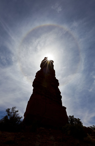
Standing Rock Sun Circle by IntrepidXJ, on Flickr
I decided to try my 16-35mm lens for the first time in the field for some nice sunbursts, which I think turned out pretty good.
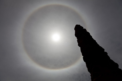
Turntable in the Sky by IntrepidXJ, on Flickr
A less colorful version, but with an interesting composition.
There was still plenty of time in the day, so we headed off to Lizard Rock and started hiking towards Tibbett Arch. There was plenty of route-finding involved, but I managed to find a nice overlook right across the small canyon from the arch. Dave, on the other hand, managed to get above and on the other side of the arch.
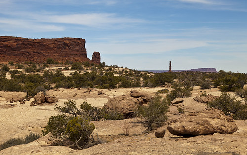
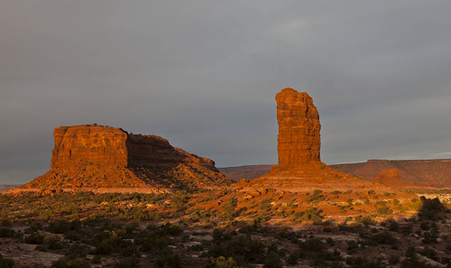
Lizard and Standing Rock by IntrepidXJ, on Flickr
The large monolith on the left is Lizard Rock, with Plug Rock just to the right of it. Standing Rock is the skinny one in the distance. Land of the Standing Rocks.
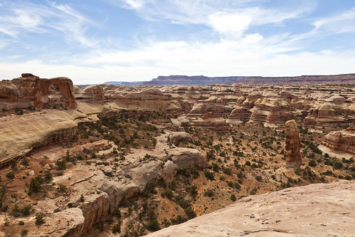
Tibbett Arch Canyon by IntrepidXJ, on Flickr
Looking down into the canyon in front of Tibbett Arch. You can see the arch to the upper left of the photo.
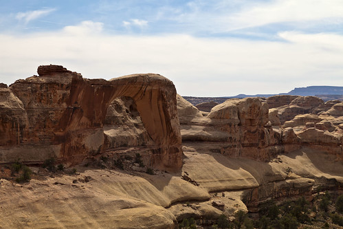
Tibbett Arch by IntrepidXJ, on Flickr
[I]A closer look at Tibbett Arch. I was hoping to get low enough to see some sky through it, but that didn
-
04-22-2011 08:47 PM # ADS
-
04-23-2011, 01:14 AM #22
Hi Randy,
Excellent trip report and a lot of very nice pictures, you seem to have had a nice time in The Maze !
The Maze has been on my wish list since many years but the hard 4WD access is an issue for me without the proper vehicule and enough 4WD skills.
Philippe
-
04-23-2011, 05:00 AM #23
Under dry conditions you can take a 2wd rental out to the Hans Flat station and then hike the trails to all of those hoodoos, arches and rock art.
-
04-23-2011, 06:59 AM #24Yes, but it would be a multiday backpacking (at least 5 or 6 days from Hans Flat) and the issue would be drinking water, all the stuff for backpacking (that I should have to bring from France) and doing it alone.Under dry conditions you can take a 2wd rental out to the Hans Flat station and then hike the trails to all of those hoodoos, arches and rock art.
I still have a plan in mind, if the weather is planned to be good (so I would not need to carry a tent), with just some beef jerky and trail mix (to be ultralight), but I am not sure if it is reasonable (even if I have already done a 2 Day ultralight backpacking from Cathedral Butte to Angel Arch and back to Cathedral Butte) :
- Coming from the dirt road beginning on Hwy 95 close to Hite, after sleeping in my car just outside the park boundary, I drive early in the morning to the top of the Golden Stairs (it should be doable with a rental SUV) and I park there With an ultralight backpack (no tent), a gallon of water in the backpack and a gallon in each hand, I hike down the Golden Stairs then on the dirt road until Doll House (hiding almost 2 gallons on the way at Standing Rock). In late afternoon I visit around Doll House and I sleep there under the stars.
- Early in the morning, I hike to Standing Rock and I do the hike to Harvest Scene. I camp at Standing Rock.
- I hike back to the top of the Golden Stairs and I leave the Maze driving to Hite in late afternoon.
Philippe
-
04-23-2011, 07:27 AM #25From what I've heard the Flint Trail should be fine in a stock SUV, Teapot Canyon on the other hand, maybe not. Randy?
 Originally Posted by Philippe

If you go through Ernie's country to get to the Dollhouse, there are a couple of springs, Lou's and Clell's. Also some springs down in the Maze canyons, even nearby Harvest Scene. There's a set of GPS tracks for a backpack loop from the top of the Golden Stairs on backpacker.com, here's the link: http://bp2.trimbleoutdoors.com/ViewT...x?tripId=48391
One other thing, I don't think the permits are in as high demand as they as they are in other districts of Canyonlands. At least not for backpacking, the vehicle sites fill fast but I know for my trip next week they didn't even come close to running out of backpacking permits.
-
04-23-2011, 08:46 AM #26Don't give up Philippe! Originally Posted by Philippe
The road to the Maze Overlook is significantly easier than to the Dollhouse. In season, there is water down at Picto-Fork so you could restock water if backpacking all the way to the Dollhouse. I can share a rental company I've used in SLC that has well-equiped Jeeps at a reasonable price. Lastly, with a little advance notice you could definitely find some folks on this site to share the adventure with you!It is good that warriors such as we meet in the struggle of life... or death. It shall be life. - Ten Bears, "The Outlaw Josie Wales"
-
04-23-2011, 08:51 AM #27
Ibenik and Paul,
Thank you very much for your useful information, I will study it closely for another trip as the schedule of my next trip in late Spring is already overbusy without The Maze.
I also like the idea of joining some folks from Bogley to visit The Maze or some other remote places.
Philippe
.
-
04-23-2011, 09:19 AM #28
Hi Phillippe...when I drove through Torrey in March, I saw a large ATV with a sign "for rent, street legal". I think it was probably this one: http://www.sandstonecapitolreef.com/atv-rentals.html
I have no idea what the cost would be, or if it would be allowed to take it that far, but perhaps it's an option worth looking into.
-
04-23-2011, 11:01 AM #29No. Only road-licensed vehicles can be driven on the NPS roads in Canyonlands. No ATVs, no dirt bikes. Originally Posted by darkmatter
Another ref I can offer is for someone who does 4WD instruction out of the LA area. Great guy and you would feel much more confident tackling the roads after a day with him. There's link on this site from TR a did doing a "Rocks" class with him.It is good that warriors such as we meet in the struggle of life... or death. It shall be life. - Ten Bears, "The Outlaw Josie Wales"
-
04-23-2011, 04:28 PM #30
excellent shots again. What a wonderful and unique landscape.

Just watching your shots has me longing to visit the area as soon as possible. Like Philippe, it is on my Must See list for such a long time.
Hopefully next year with a rental 4x4 that can do some of the tricky parts.
But I'm still not sure of heading out to the Maze by myself.
-
04-24-2011, 06:50 AM #31As long as the road is in good shape a stock SUV should have no problem on the Flint Trail. It's not too rough, just narrow. You'll also need to make a 3-point turn or two at some of the switchbacks. I had to make 2 3-point turns in my 4-door Wrangler. An SUV with high clearance would be best. Originally Posted by ibenick
-
04-24-2011, 08:42 PM #32
Day 4: From the Maze to the Mesa
Tuesday, April 12, 2011
On our forth day Under the Ledge, we awoke to an awesome sunrise. The colors in the sky were just amazing! I quickly hopped out of my tent and grabed my camera for a photo. When I got my shot composed, I realized that I had taken the battery out the previous night to charge in the Jeep…and hadn’t replaced it! I ran back to the Jeep and grabbed the fully charged battery, but missed the best colors of the sunrise in the process. Here’s the shot I managed to get before all of the colors disappeared.
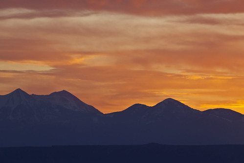
Color Over the La Sals by IntrepidXJ, on Flickr
After the colors over the La Sal Mountains were gone, I turned around and took a few more early morning shots.
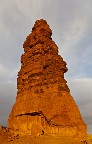
Standing Rock on Fire by IntrepidXJ, on Flickr
Standing Rock bathed in golden early morning sunlight on our last day in the Land of Standing Rocks.
Lizard and The Plug by IntrepidXJ, on Flickr
Lizard Rock and The Plug glowing in the early morning sunlight.
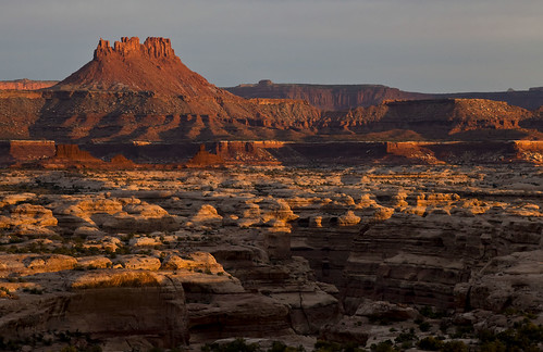
First Light by IntrepidXJ, on Flickr
The first light of the day strikes Ekker Butte and the rims of the canyons that make up The Maze.
After sunrise we had some breakfast and packed up camp so that we could move on. We would have a long and full day ahead of us, since we would be leaving The Maze and heading to Cedar Mesa…but there would be plenty of stops along the way.
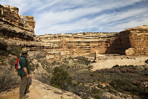
Before leaving The Maze we parked near Mother and Child Rock so that we could hike a little way into into Ernie’s country. We dropped down into Range Canyon so that we could visit Cedar Bark Ruin and Lou’s Spring.
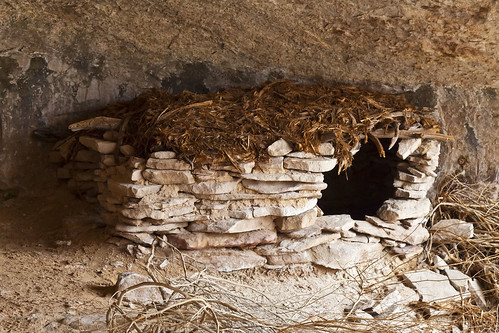
Cedar Bark Ruin by IntrepidXJ, on Flickr
There has been some disagreement as to how old this ruin actually is, however, after seeing it in person, in my opinion, the ruin itself looks pretty old and not recently made, but the roof certainly looks newer, like someone may have added it. I’m no expert and these are just my impressions from my visit to the site.
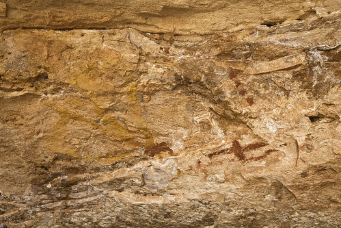
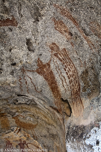
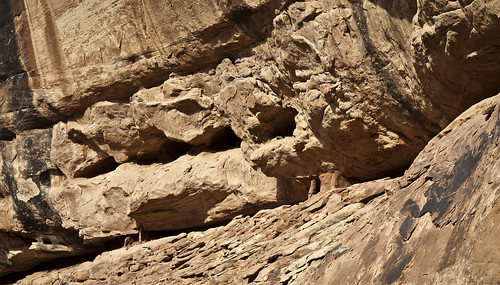
Lous Spring Pictographs by IntrepidXJ, on Flickr
These very faint pictographs found on the ceiling of the alcove that contains Lou’s Spring kind of remind me of the one’s located across the Colorado River in Cave Spring in the Needles District.
After reaching the Jeeps again, we finally started to head out around Teapot Canyon. Along the rough road we met some of Canyonland’s rangers in 4
-
04-24-2011, 08:44 PM #33
After leaving The Maze we made our way over to pick up Jared’s car before heading over to Cedar Mesa for the rest of the week. Along the way we stopped at a few rock art sites. Here’s a bunch of photos from the sites we visited.
The Hollow Boulder Panel:
Hollow Boulder by IntrepidXJ, on Flickr
An overview of the Hollow Boulder Panel. I’ve seen a lot of rock art, but this panel is certainly in one of the more unusual locations, especially for a Barrier Canyon Style panel. As you can see, these pictographs are located inside a large boulder that has a naturally hollowed out area big enough to stand in. Step inside and you are treated to an almost 360 degree display of rock art!
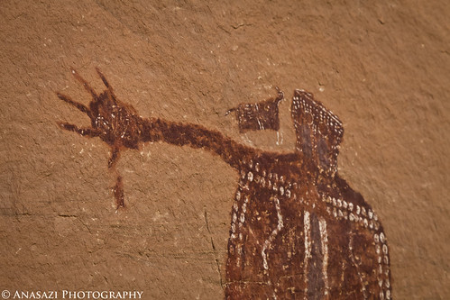
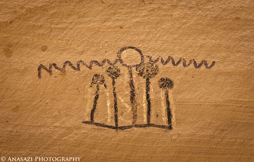
Snakes In Hands by IntrepidXJ, on Flickr
One of the more interesting figures in the Hollow Boulder is this anthropomorph that appears to be holding five snakes.
Inside the Boulder by IntrepidXJ, on Flickr
A better look at the back of the boulder.
Many Hidden Pictographs by IntrepidXJ, on Flickr
There are a lot of pictographs hidden inside this boulder.
North Wash Pictographs & Petroglyphs:
On the Road Again by IntrepidXJ, on Flickr
On the road in North Wash.
The Queens Alcove by IntrepidXJ, on Flickr
This photos shows just a small part of the very large alcove these are located in.
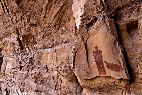
The Queen & I by IntrepidXJ, on Flickr
A closer look at the large anthropomorph and it’s attending dog.
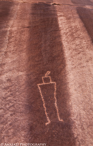
Striped by IntrepidXJ, on Flickr
An interesting anthropomorph petroglyph set within some varnish-stripes.
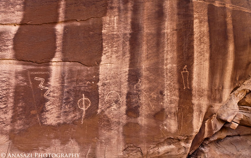
Striped Panel by IntrepidXJ, on Flickr
The full petroglyph panel over the stripes.
-
04-24-2011, 08:45 PM #34
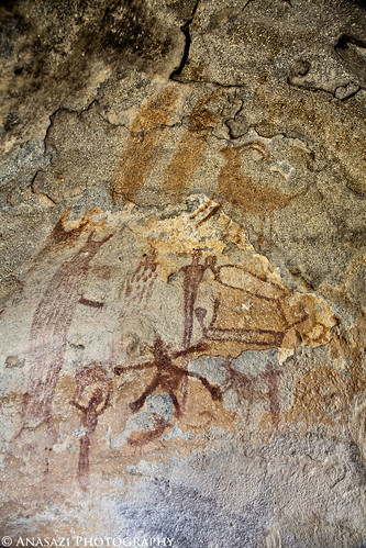
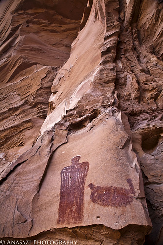
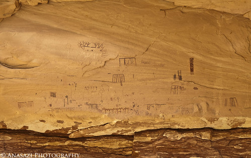
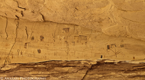
The Perfect Panel

The Perfect Panel by IntrepidXJ, on Flickr
One of the most amazing pictograph panels I have visited. In the following photos, just check out how detailed these pictographs are. You can also see quite the resemblance to The Queen pictograph pictured just above.
Thumbs Down by IntrepidXJ, on Flickr
[I]A closer look at the
-
04-26-2011, 08:24 PM #35
Day 5: Sheiks Canyon & The Green Mask
Wednesday, April 13, 2011
We were up before sunrise on Wednesday for a quick breakfast so that we could get a quick hike down into Sheiks Canyon before Dave would have to head back home. First up in Sheiks Canyon was the Yellow House Ruin. The roof beams over part of this ruin still have the yucca lashings with knots tied to the roof beams. It’s a pretty amazing site.
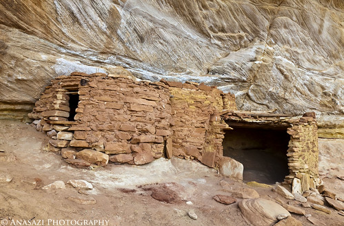
Yellow House by IntrepidXJ, on Flickr
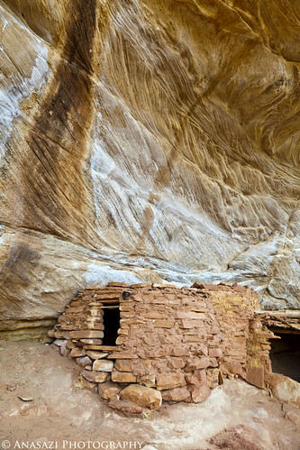
Yellow House Alcove by IntrepidXJ, on Flickr
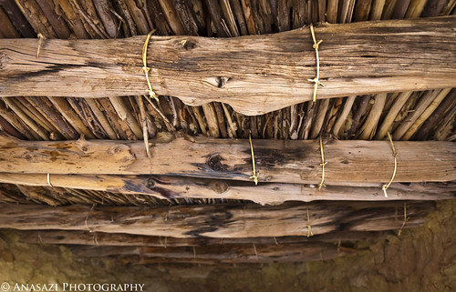
Yellow House Roof by IntrepidXJ, on Flickr
A good look at the very cool roof structure still intact.
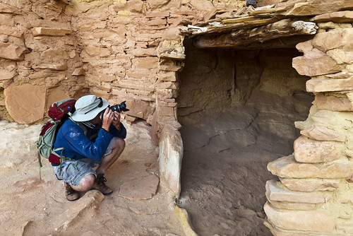
Jared and the Yellow House by IntrepidXJ, on Flickr
Jared takes a photo into the Yellow House.
A little further down the canyon we came across another small ruin.
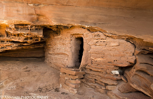
Welcome Mat by IntrepidXJ, on Flickr
This small structure has a unique step right in front of the doorway.
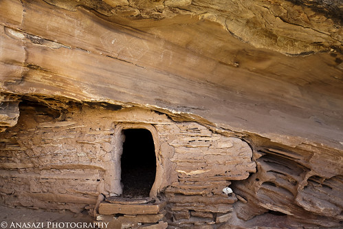
Ruin & Faint Pictographs by IntrepidXJ, on Flickr
It also has some faint white pictographs located just above, than you can see in this photo.
As we continued down-canyon were a couple of steep talus slopes we needed to descend to get around some big pour-overs.
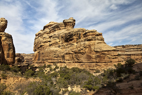
Sheiks Canyon by IntrepidXJ, on Flickr
A view into Sheiks Canyon as we near Grand Gulch.
Dave and the Gulch by IntrepidXJ, on Flickr
Dave looking down into Grand Gulch from a viewpoint along our hike.
Tucked-Away Granary by IntrepidXJ, on Flickr
A small granary we passed by on our way to The Green Mask alcove.
-
04-26-2011, 08:24 PM #36
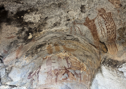
Once we got near the confluence with Grand Gulch we spotted the Green Mask alcove with it’s ceiling filled with pictographs.
Ceiling Panels by IntrepidXJ, on Flickr
There were a lot of pictographs located near the ceiling of this alcove and out of reach. There are more in the photo below.
Ceiling Panels 2 by IntrepidXJ, on Flickr
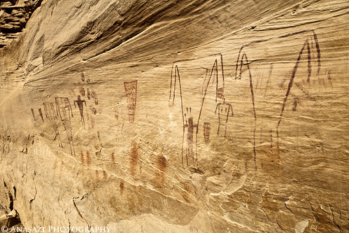
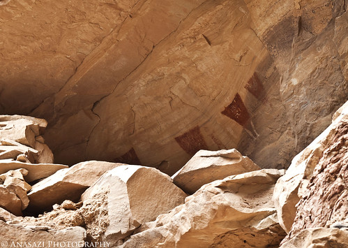
Alcove Pictograph by IntrepidXJ, on Flickr
Here’s a closeup of one of the more interesting and unique pictographs located above us.
There were plenty of ruins and rock art around to explore.
Headless Torso Wall by IntrepidXJ, on Flickr
This area had a bunch of pictographs and handprints, including the Breech Birth Panel.
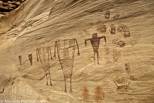
Handprints & Torsos by IntrepidXJ, on Flickr
A closer look at the left side.
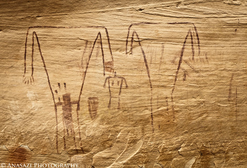
Breech Birth Panel by IntrepidXJ, on Flickr
This section is called the Breech Birth Panel. Apparently, some people believe this scene represents a C-section birth.
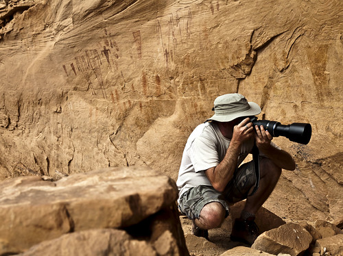
Shooting Rock Art by IntrepidXJ, on Flickr
Jared takes a photo of some rock art.
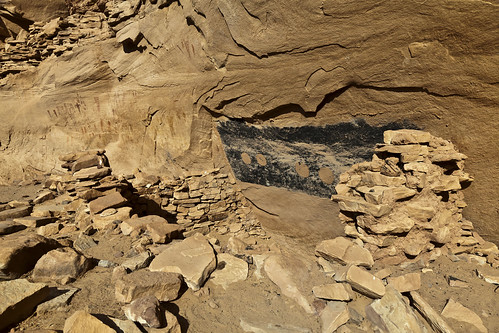
Painted Walls by IntrepidXJ, on Flickr
The back of this ruin appears to have been painted.
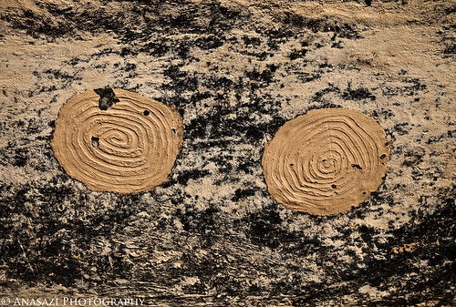
Mud Spirals by IntrepidXJ, on Flickr
A closer look reveals that mud circles were applied to the back wall inside this ruin and then spirals were created. This is the first time I have come across this, and it was pretty cool.
-
04-26-2011, 08:25 PM #37
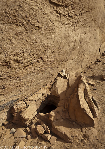
Hidden Room by IntrepidXJ, on Flickr
The entrance to a small room or granary located along the back of the alcove.
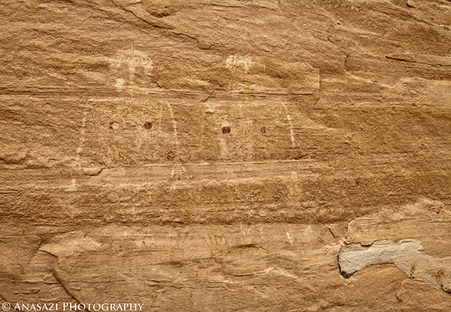
Upper Panel by IntrepidXJ, on Flickr
I was unable to climb up to these anthropomorphic pictographs located in a ruin on a ledge above us, so this is the best shot I was able to get.
White Turkey Panel by IntrepidXJ, on Flickr
More faint white pictographs. The lower bird-like figure in white reminds me of a turkey, which is where my name comes from.
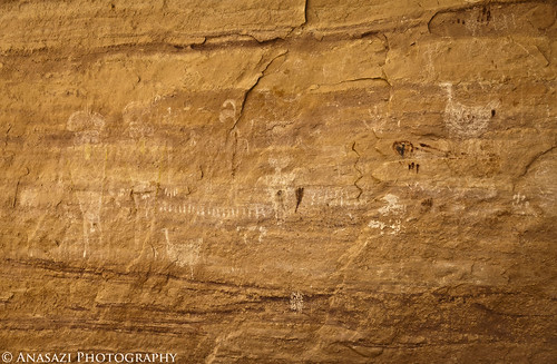
Faint Headress Figures by IntrepidXJ, on Flickr
Two faint anthropomorphic figures with headdress-like designs where their heads should be.
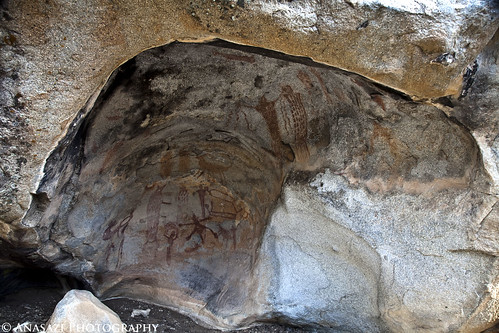
Of course, I had to get a photo of The Green Mask before we left.
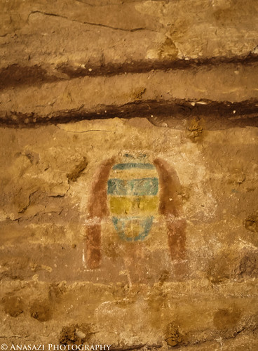
The Green Mask by IntrepidXJ, on Flickr
[I]I wish I had dragged my 100-400mm lens along on this hike so I could have got a better shot of this, but here
-
04-27-2011, 12:45 PM #38
Randy
You can access the upper ruin and pictographs at Green Mask, head down canyon about 100 feet and then start climbing up, and then down into it. Nice shots, BTW.
-
04-27-2011, 01:06 PM #39
More awesomeness! I'm late getting my CM stuff together. We wanted to do Sheik's but circumstance prevented it.
It is good that warriors such as we meet in the struggle of life... or death. It shall be life. - Ten Bears, "The Outlaw Josie Wales"
-
04-27-2011, 01:47 PM #40Some people can....I couldn't.....it was out of my comfort zone....I have no climbing skills. My friend Dave who was with us got up there. Originally Posted by gnwatts


 Reply With Quote


Similar Threads
-
April 2011 Trip Report Contest - Win $50
By Sombeech in forum General DiscussionReplies: 38Last Post: 05-01-2011, 10:55 PM -
[Trip Report] Bells Canyon- April 1st, 2011
By Dr. Nebz in forum Hiking, Scrambling & Peak BaggingReplies: 8Last Post: 04-20-2011, 12:53 PM -
[Trip Report] TR - Cedar Mesa, Jan 2011
By Deadeye008 in forum Hiking, Scrambling & Peak BaggingReplies: 23Last Post: 04-06-2011, 07:54 AM -
Backpacking Partners mid April-May 2011
By lofty in forum Backpacking & CampingReplies: 3Last Post: 02-01-2011, 09:08 PM -
[Trip Report] Well, OK, a TV (Trip Video) - The Maze - April 2007
By Cirrus2000 in forum Backpacking & CampingReplies: 6Last Post: 09-02-2007, 05:25 PM
