

Results 1 to 18 of 18
Thread: Canyonlands Road Closures
-
08-29-2010, 04:24 PM #1
Canyonlands Road Closures
Thought this might be good info to post here, in case you were planning a trip that way soon:
Hopefully they fix some of them soon, or my plans for this fall will be changing
:)
--------------------
Date: August 24, 2010
Contact: Backcountry Reservation Office, 435-259-4351
Updated: August 28, 2010
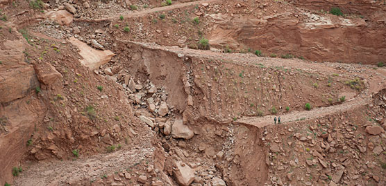
On August 19th, severe storms caused flash flooding and rock falls that blocked or washed away roads throughout the Canyonlands area. One of the more dramatic washouts occurred on the Mineral Bottom Road switchbacks (see photo), where signifcant portions of the road were obliterated. This damage will affect all groups traveling the White Rim Road or planning river trips that launch or take-out at Mineral Bottom.
PHOTOS
View enlarged photo [422k JPG file]
View enlarged detail of washout [322k JPG file]
View enlarged photo (vertical) [358k JPG file]
These photos may also be viewed in the gallery below.
CURRENT CONDITIONS
Island in the Sky District - White Rim Road
Due to the total failure of the switchbacks on the Mineral Bottom Road, it is currently impossible to complete the White Rim as a loop. The Shafer Trail and Potash roads are open; however the White Rim Road is currently closed to motor vehicles just beyond Potato Bottom. You cannot access the Hardscrabble, Labrinth or Taylor campsites by motor vehicle.
There are no current estimates for when Mineral Bottom will again be accessible by road; however it will likely be several months. We have temporarily suspended making reservations for the White Rim for calendar year 2011.
We will update this webpage as information becomes available. Those with White Rim permits for the next couple of months should contact the reservation office (open Monday through Friday) at (435) 259-4351.
Green River - Mineral Bottom
All roads to Mineral Bottom are impassable. There are no current estimates for when Mineral Bottom will again be accessible by road; however it will likely be several months.
Needles District
All four-wheel-drive roads are closed. This includes Elephant Hill, Confluence Overlook, Horse Canyon/Salt Creek and Lavender Canyon.
Maze District
The roads from Utah Highway 24 to Hans Flat or Horseshoe Canyon currently require high-clearance, four-wheel-drive vehicles. The road from Green River to Horseshoe Canyon is impassable. All other roads are open.
If you are planning a trip to the park that involves backcountry travel by vehicle, please contact district visitor centers for the most up-to-date conditions:
Island in the Sky District Visitor Center: (435) 259-4712
Needles District Visitor Center: (435) 259-4711
Maze District Ranger Station: (435) 259-2652
-
08-29-2010 04:24 PM # ADS
-
08-29-2010, 04:41 PM #2
Wow. Wonder if anyone got trapped further down the road?
-
08-29-2010, 04:42 PM #3
 Originally Posted by ibenick

Yep, there's still a few cars down there.
http://www.moabtimes.com/view/full_s...ome_news_right
-
08-29-2010, 04:53 PM #4
Whoah!

-
08-29-2010, 07:40 PM #5
wow! that will be a big job to repair.
But if I agreed with you, we would both be wrong.
-
08-30-2010, 06:07 AM #6
Backcountry Road Storm Damage
Page, AZ Recent monsoon rains washed out portions of several backcountry
roads in Glen Canyon National Recreation Area. Portions of
Hole-in-the-Rock Road, the Burr Trail, and Blue Notch Road may be
impassable, even for high clearance four-wheel drive vehicles.
County road crews are working to repair storm damage. Visitors are advised
to contact local ranger stations regarding road conditions before embarking
on backcountry travel.
The National Park Service Bullfrog Visitor Center in Bullfrog, Utah can be
reached at 435-684-7423, the Bureau of Land Management Big Water Visitor
Center can be reached at 435-675-3200, and the Escalante Interagency
Visitor Center in Escalante, Utah can be reached at 435-826-5499.
-
08-31-2010, 11:34 AM #7
Damn, I hope some of these roads reopen by Mid- October. Lavendar Canyon was high on my "to do" list. Thanks for the postings.
WinQuoting my best friend, Bob McNally, after a bad boating trip: "Nature scares me!"
Utah photos: www.winpics.fototime.com
-
09-03-2010, 08:12 AM #8
That would be such a logistical nightmare! I mean if Mineral Bottoms was your take out, and you ate all your food already and running low on water, you couldn't make it to the next take out, and even then who's going to take you out?
I usually pack more water and food than I need, but this is a really good example of why it's a good idea!
And the folks that got helicoptered out, did they have to leave all their boats and gear?
-
09-25-2010, 02:07 AM #9hopefully not Originally Posted by ibenick
-
10-05-2010, 06:17 AM #10
A friend pointed this out to me at work yesterday. Pretty amazing pictures.
http://www.nps.gov/cany/news082410.htm
-
10-05-2010, 11:40 AM #11
Wow, I just drove the White Rim last spring. Went in this way.
Good luck fixing that.
-
10-19-2010, 06:12 AM #12
The Tribune has a story this morning about this.
http://www.sltrib.com/sltrib/news/50...ounty.html.csp
-
10-19-2010, 07:58 PM #13
Meh. Just need bigger tires and a powerful winch, right? ;)
-----
"It's a miracle curiosity survives formal education" - Albert Einstein
For a good time, check out my blog. or update the CanyonWiki
-
10-25-2010, 08:22 AM #14
We were in Needles last week and checked on road conditions. I was most interested in Davis/Lavender Canyons and the park boundary is inaccessible. At the VC they told me the road is county/BLM maintained and they had no idea when it would be fixed. Elephant Hill is open but we opted to hike instead.
WinQuoting my best friend, Bob McNally, after a bad boating trip: "Nature scares me!"
Utah photos: www.winpics.fototime.com
-
02-25-2011, 03:00 PM #15
I posted this in General Discussion since so many different users are on that road. It looks like repairs are going well and it should be open before summer.
http://www.moabtimes.com/view/full_s...-spring’?Remember kids, don't try this at home. Try it at someone else's home.
-
02-26-2011, 04:41 PM #16
Today I heard that the road is scheduled to be open March 28.
Utah is a very special and unique place. There is no where else like it on earth. Please take care of it and keep the remaining wild areas in pristine condition. The world will be a better place if you do.
-
02-27-2011, 05:55 AM #17Carbon Footprint Donor


- Join Date
- Jan 2007
- Location
- In Nothing But Sunshine
- Posts
- 8,849
Mother Nature still has it
-
04-01-2011, 04:08 PM #18
OPEN


 Reply With Quote


Similar Threads
-
Anyone know if Wild Horse Road (Co Road 103) is closed off past a certain point now?
By Ryebrye in forum Offroad 4x4, Side by Side and ATVReplies: 2Last Post: 07-28-2010, 09:23 AM -
2010 Zion Climbing Closures
By Iceaxe in forum Climbing, Caving & MountaineeringReplies: 1Last Post: 03-01-2010, 09:17 PM -
Closures?
By Bo_Beck in forum CanyoneeringReplies: 4Last Post: 07-30-2009, 10:00 PM -
Road closure on LaSal loop Road??
By neilether in forum Mountain Biking & CyclingReplies: 0Last Post: 10-25-2007, 12:56 PM -
Zion National Park Announces Schedule of Climbing Closures
By Iceaxe in forum Climbing, Caving & MountaineeringReplies: 0Last Post: 02-28-2006, 03:42 PM
Visitors found this page by searching for:
Outdoor Forum
