Results 1 to 10 of 10
Thread: Richard's Hollow - Logan
-
07-24-2010, 09:05 PM #1
Richard's Hollow - Logan
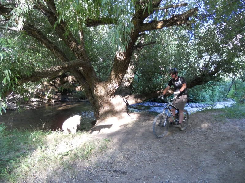
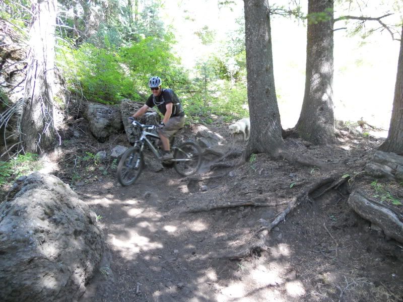
e rode Richard's Hollow today. If it weren't for the 9 mile climb on the jeep road, this trail would truly amazing. Even with that climb, it is still my favorite piece of singletrack (6miles) in the Logan area. Lots of flow, some tricky technical sections, a little bit of everything. The cows aren't in this canyon yet, but they will be shortly. Get it while the gettin's good.
Jeep trail parallels the stream for a couple of miles
This is one busy beaver


Fast smooth singletrack


-
07-24-2010 09:05 PM # ADS
-
07-25-2010, 09:26 AM #2
That looks sweet!
Chere'

-
07-26-2010, 10:23 AM #3
Nice!
 Still trying to get in riding shape.
-
07-26-2010, 03:37 PM #4
Believe it or not, I still haven't ridden Richards.
I've hiked it a dozen times or maybe more but have yet to find the right day to ride it.seen all good people turn their heads each day so satisfied I'm on my way...
-
07-26-2010, 06:03 PM #5
So is it an out and back @ 30 miles? Got any google map coordinates? I wouldn't mind trying this.
-
07-27-2010, 07:12 AM #6
Some superhuman type people will ride just the singletrack portion as an out & back, but the bottom half is pretty steep. Typically we just ride the jeep road around and make a loop out of it (up the jeep road, down the singletrack). It is about 14.5 miles if you do the shortest version of the loop. I have attached a Google Earth File (not savvy enough to embed the track right into the forum.....any pointers??) to this post for your viewing pleasure. This loop was ridden counter-clockwise.
Hmmm, so I tried to attach a .kml file but that is not an allowed attachment type. Any help embedding the google earth gps track would be appreciated......
-
07-27-2010, 08:14 AM #7
-
07-27-2010, 08:21 AM #8
Looks sweet, I tried to ride up here last year and took a wrong turn and ended up riding 25 miles up some gnarly atv trail. Butt paid the price for that mishap.

Two wheels are better than four, keep the rubber side down.
-
07-27-2010, 12:48 PM #9
It's amazing what you can learn if you just go look at the sticky posts. Thanks for the tutorials. Without further adieu:
Viewing on a mobile device? Click this link to open the map: http://maps.google.com/maps/ms?ie=UTF8&hl=en&msa=0&msid=107942267772270744381.00048c63bfee6951d15cb&ll=41.686502,-111.672249&spn=0.203062,0.442543&t=h&z=12
This track file is perhaps a little confusing. Typically, you would drive from Blacksmith fork Canyon to Left Hand for turnoff. From there you would drive a few miles on a rough dirt road to the Friendship Campground and park there. That is the south western point of the actual loop (there is a flag on the map there). Then you proceed on the jeep road (on which you were initially driving) for a couple of miles until there is an intersection with another Jeep Road heading north. You go north at the intersection. Keep going a few more miles until you get to the top of a climb in a big open meadow. It is a large 4-way intersection at this point. Proceed West. Climb another couple of miles until you see the Richard's Hollow Trail sign on your left. Enjoy! It's all downhill from here. The ride would typically end back at your car (naturally). However, we were running a little behind and were supposed to meet somebody back at the Blacksmith Fork turnoff. The dirt road is actually a fair bit faster on a bike, so I rode out to the road while everybody else loaded up and drove out. That's why you see that little spur heading southwest from the TH.....
-
07-27-2010, 01:28 PM #10True. That road was a mess when I drove it in June.
 Originally Posted by neilether

I wouldn't be surprised if they're planning to regrade it very soon.seen all good people turn their heads each day so satisfied I'm on my way...


 Reply With Quote


Similar Threads
-
[Trip Report] TR - Sink Hollow (Logan Canyon)
By neilether in forum Mountain Biking & CyclingReplies: 1Last Post: 08-13-2009, 08:37 AM -
Logan Trails?
By whyisjake in forum Offroad 4x4, Side by Side and ATVReplies: 3Last Post: 05-05-2009, 07:29 AM -
Elk rescued from 1st Dam in Logan
By Sombeech in forum Hunting & ShootingReplies: 4Last Post: 02-17-2009, 06:19 PM -
[Trip Report] Richard's Hollow
By neilether in forum Mountain Biking & CyclingReplies: 21Last Post: 07-14-2008, 04:04 PM -
[Trip Report] Logan River TR
By mtnbiker62 in forum Mountain Biking & CyclingReplies: 3Last Post: 04-30-2006, 12:01 AM
Visitors found this page by searching for:
Outdoor Forum