

Results 1 to 19 of 19
Thread: Wire Pass to Lee's Ferry
-
04-10-2010, 09:46 PM #1
Wire Pass to Lee's Ferry
Day 1: Spa Treatments and Mud Baths
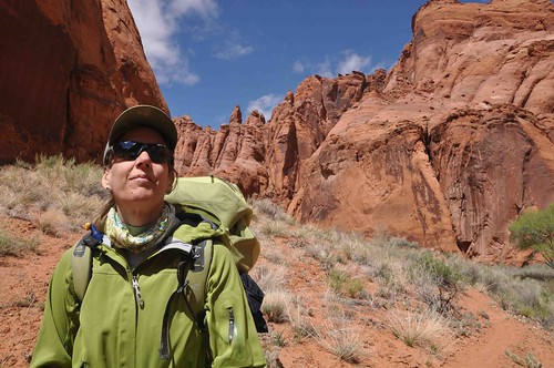
It's become a yearly tradition to do a spring break trip somewhere in the Colorado Plateau. Once you have a school age kid your vacation times become limited to Summer, Christmas and Spring Break. This year it was different because Aaron decided he wanted to go on a school-sponsored educational trip to D.C. So Robin and I were on our own for the first time in many years.
We arranged our flights to coincide with Aaron's. Unfortunately, his trip was only from Friday night until Thursday night which limited our time. To make it a tad worse bad weather in San Francisco backed up all the flights and we got to Las Vegas at 1:00 AM. Saturday we drove on to St. George to pick up some supplies like rolls, cheese and isobutane. Of course, we hit the Desert Rat to get the fuel!
I was worried about high water levels in the Paria and maybe Buckskin too and wanted to bring something to float our packs. I tried to find a place to pick up some inner tubes locally but couldn't find anything in the last days before I left. I found a truck tire store in St. George but they were closed on Saturday. Bo came to the rescue and picked them up for us (actually his coworker did). What service!!!
It was great chatting with Bo at the store and we couldn't help drop some change there when we saw some sweet jackets at 60% off. I also found a vest to use for running that I had my eye on at REI. I almost bought it for full price there the week before and instead now snagged it at -60%. Nice!
Saying our goodbyes we headed on towards Page. I already had my permit and didn't stop at the BLM office near the White House trailhead. But as I passed the other BLM office closer to Page I thought better and decided to inquire about conditions. The young lady at the office didn't seem to really know anything about backcountry conditions. But then said, "Oh, did you say *Buckskin*? **Buckskin???". Uh, yes I did. She got this incredulous look on her face as if to say "are you mad?" and pointed to a color photocopy on the desk in front of me. It showed a smirky looking gent in a BLM cap standing next to the entrance to the Buckskin narrows with a torrent of water flowing below him and on into the slot. His expression was clearly designed to say "See it's impassable"! Handwritten on top of the page was 04/10. This was 04/03/10 so it had to be quite recently taken.
I decided not to show that photo to Robin
On to Page. We decided on a whim to check out the Wal Mart and found some lighter swimming pool float rings to take instead of the truck tubes. But fear not Bo, we brought the truck tubes home and hope to use them on the Merced in Yosemite this summer!
The next morning we met Betty at Lee's Ferry. Just like Kev we got the time mixed up! I think it's partly Betty who makes the time confusing by not always just saying X-o'clock Arizona time. Anyway were were a little early so as not to be actually that late. Betty is a character. Part tour guide, part outfitter. She stopped to give us a eye test to see if we could spot a "cow" in the desert varnish on a rock. We failed
Then she was explaining about recent folks' experience in Buckskin/Paria. She told us the water would be mostly waist deep but then must have said 3 times "Except the CESSPOOL will be chest deep" (emphasis hers). She also added that of course, "the scorpions and rattlesnakes are out now". Making it sound like it would be like night crawlers on the sidewalk after a summer rain with the snakes and arachnids littering the trail on all sides. This was not helping Robin to feel at ease
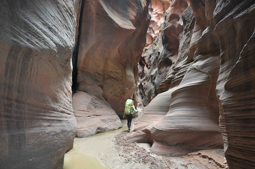
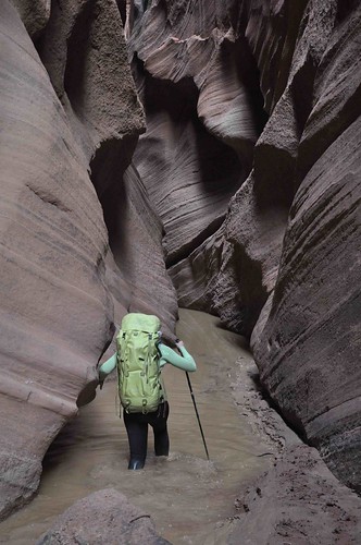
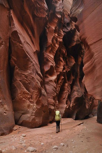
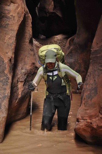
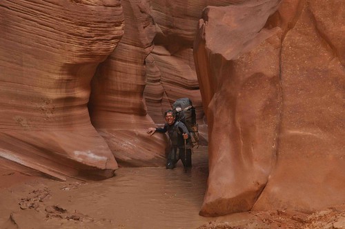
Soon enough she was driving away and we were shouldering our packs down the Wire Pass trail as some Pinyon Jays squawked in the pines nearby. We made great time down to the Buckskin and on to the start of the slot. No torrent of water. Whew. Talking to Betty we learned that it had been flowing a 2 days earlier when there was a big melt of recent snow from Buckskin Mountain. In about 30 minutes more walking we came to the first pool. We switched into wetsuits and Keens with running socks under Neoprene socks. This first pool wasn't more than knee deep and soon ended. But on the other side it was quite muddy. Sometimes there was a trail of footsteps which had stamped out a less muddy path but other times the mud was too wet and we had to step carefully through it lest we slip and boy was it slippery. It dawned on me that this mud was probably the result of the recent flow I saw in that photo at the BLM office.
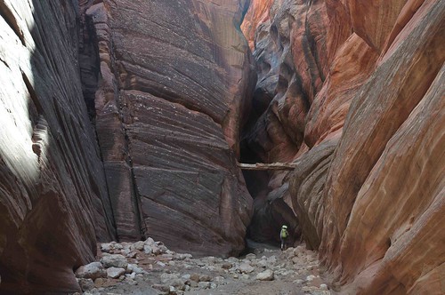
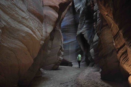
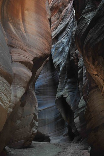
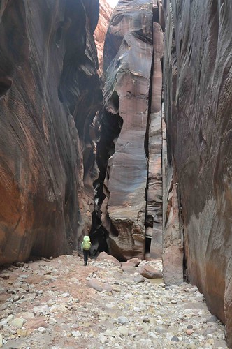
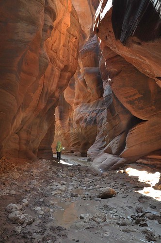
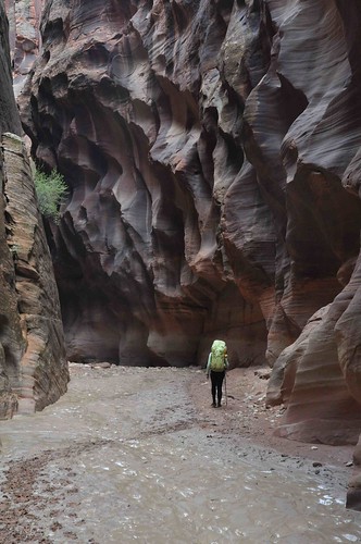
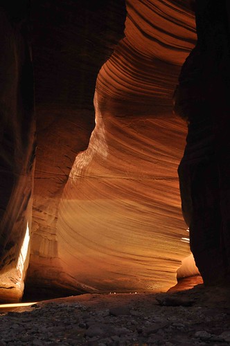
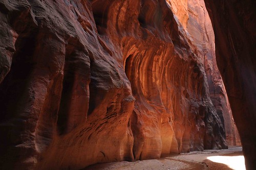
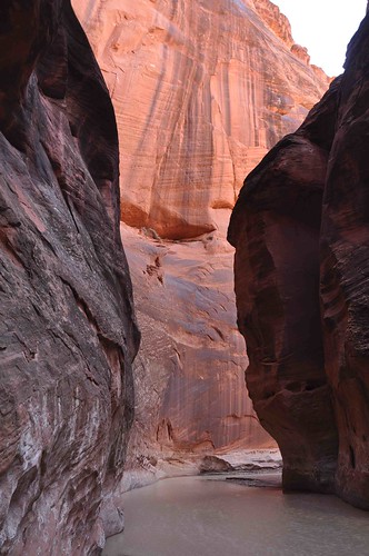
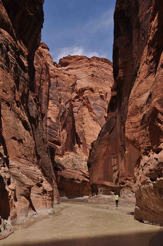
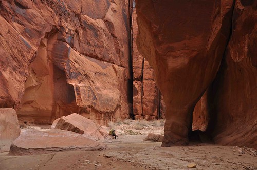
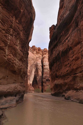
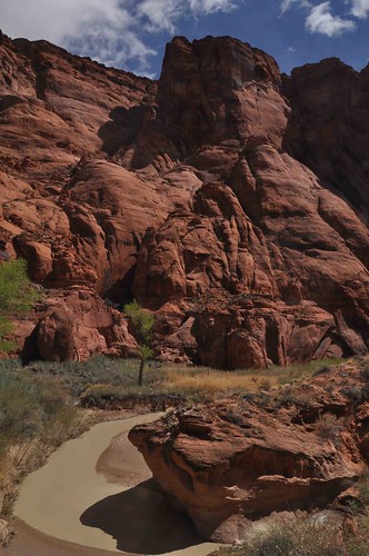
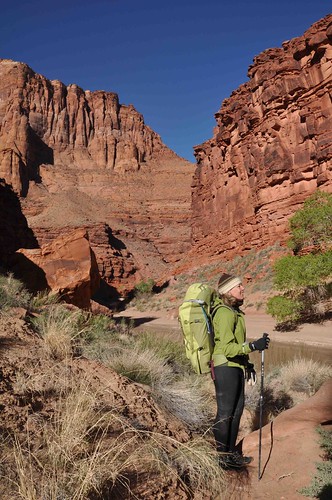
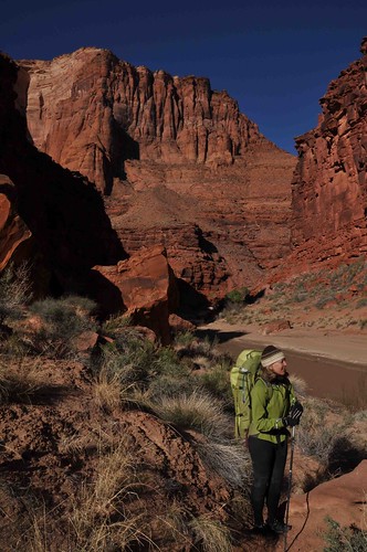
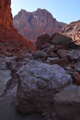
Here's some shots from this earlier part of Buckskin Gulch:

It was a long way until the next pool and we felt a bit silly in our wetsuits but the mud made progress slow. We just couldn't walk quickly because we needed to watch each step. Eventually the pools start up again. Now they were deeper and the bottoms were very muddy and slippery too. In some places we would sink in past our ankles in mud while wading. This was unnerving and we also found it would start to suck our Keens off our feet! You had to carefully try to pull your foot out and sometimes reach down and pull up the shoe with your hand. Also we started to get rocks in our shoes and had to stop and fix them often. I know what you are all thinking: Canyoneering shoes would have been better.
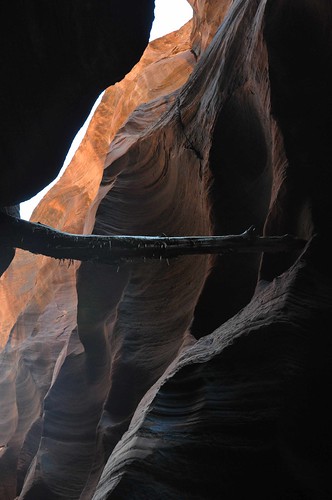
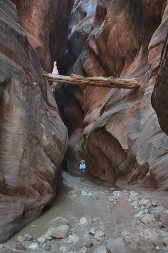
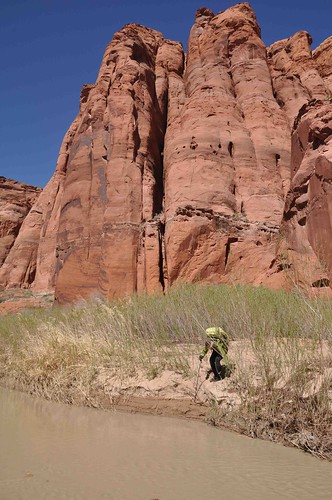
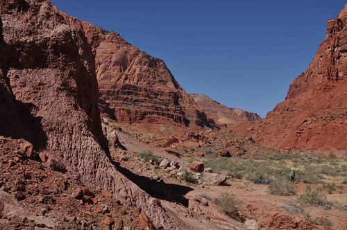
The compensation for this toiling in the mud was the incredible other-worldly beauty of the slot canyon. Twisting patterns in the Navajo sandstone and mile after mile of mind blowing convoluted tunnels of rock.
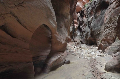
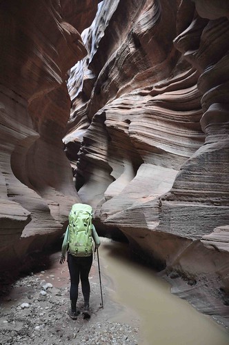
Sometimes it opens up a bit into a long wide "room" which looks like it comes to a dead end. But at the end you find a small crack to enter and continue into the bowels of the earth.
And so it continued for hours. It's hard to judge your progress but I had studied the map enough to know that the gulch changes general direction and has a few unique spots where it heads due south or north. So I used a compass to determine our general progress. But there is a very long part with no major changes in direction and I feared our progress was quite slow.

We finally reached the Middle Route Exit. My fears were confirmed. It had taken us 7 hours to travel those 8 miles and there was no less than 3 hours until dark. It would surely take us all of that and more to reach the confluence and (hopefully) water. Plus I knew that 3 or 4 more hours would push Robin to the edge. Fortunately I had a Plan B. I was carrying extra water and we could comfortably camp here and continue on to the confluence tomorrow. It was just as well the last hour had taken its toll on Robin and she was starting to doubt herself and wonder if she could handle much more of the mud.
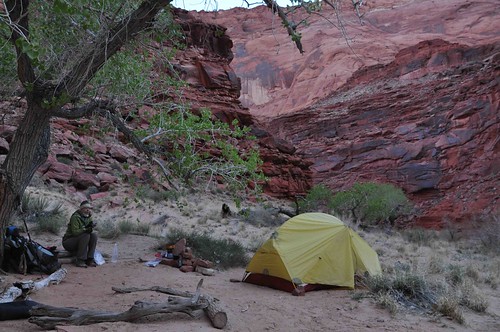
We climbed up onto the shelf on the opposite side of the exit route. There was still some sunlight here and the sounds of nearby Canyon Wrens echoed off the walls. After changing into warm dry clothes and eating a bit our attitudes improved greatly. It was in one of those quiet moments of starting feel good again that my eyes focused on the opposite wall and my brain said "you are looking at petroglyphs". Cool! Even though Bo had reminded me to look for them I sure would have missed them if we had continued on and not made camp.
We were too tired and not really hungry enough to cook a meal. Instead I made soup and we ate snacks. I must have mentioned 3 times how much I was looking forward to a "refreshing moist towlette" that it became a running joke. Sleeping on a hard sloping rock wasn't great but we were glad to be warm, dry, hydrated and nourished. I think it was about this time that Robin said,
"You know, some husbands take their wives to luxury hotels with spa treatments". I replied, "I know! Poor things. How unlucky they are to miss all this"! It is good that warriors such as we meet in the struggle of life... or death. It shall be life. - Ten Bears, "The Outlaw Josie Wales"
-
04-10-2010 09:46 PM # ADS
-
04-10-2010, 10:17 PM #2
Day 2: Getting that sinking feeling
Night was a bit windy but it dawned clear. Clear and cold that is. Our shoes and neoprene socks were caked with mud and now stiff. It was very difficult to get them back on, especially the socks. About this time we found that the muddy water started to take its toll on our hands. They were getting abraded by the silt and the need to keep tugging and pulling at our shoes and socks. Our cuticles were cracking and starting to bleed and our thumbs were raw.
The stunning beauty of the entrance back into the narrow slot at the end of the Middle Route helped us forget our aches and pains.

As we started down the first narrow slot a pair of Ravens called out raucously from above us. They were also flying down canyon but we couldn't see them from deep within that magical spot. Apparently the BLM gives them special exemptions from the rule to "keep your voices quiet while in the canyon".
Then next 5 miles were definitely easier than the last 5 the day before. There were some pools but not as many. We never encountered any pool deeper than waist deep and none had the piquant perfume of cesspool.
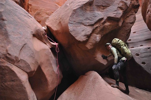
The Boulder Jam was easily passed by making a hand line with some overhand bites for hand/foot holds. I noticed that the last party set up and left their rope at the wrong place; a sheer drop of about 20 feet. Fortunately I knew I was looking for a landing on a sloping rock and that there should be an alternate slab with moqui steps. I moved their rope to keep other parties from taking that descent.
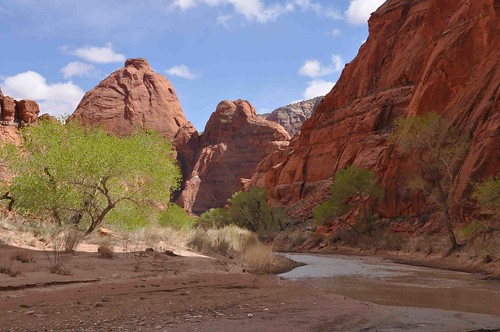
It was still about 4 hours to the confluence, but what a relief it was to reach it and some sunny spots.

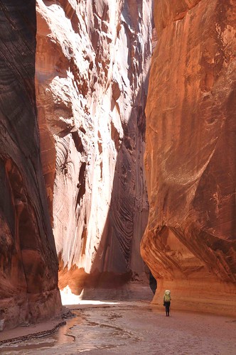
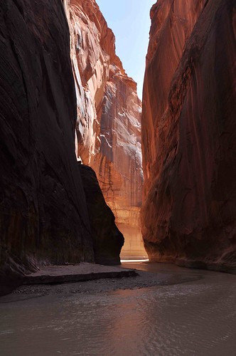
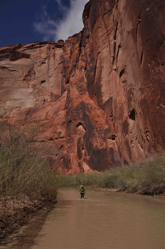
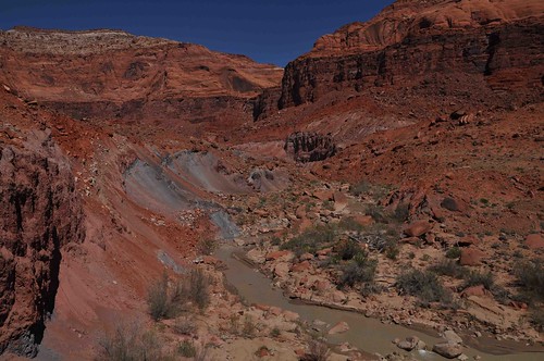
The Paria was flowing well but not too deep here. Maybe mid-shin. We had two choices for camps. One in 5 miles and one 8 miles further. I knew we were going to have to do some 13+ mile days one way or the other, but I felt it would be better to end strong than try to push early. So we relaxed a bit and enjoyed the narrows of the Paria with it's soaring walls and labyrinths of turns. The route here is more or less walking in the river. Sometimes there was a short bank we could use but soon you either had to cross or just continue down the river channel itself. It was here we encountered our first quicksand. Several times in the dark colored sand at the edge of the river we would start to sink as it liquified under our feet. You would try to step out quickly but the steps nearby usually started sinking as well. It wasn't dangerous per se but it did take up energy especially while wearing a pack. It was also important to feel the river bottom with our poles and probe for soft mud which would also cause you to sink. It's not fun to be thigh or waist deep and feel your feet sinking further underneath you!
The scenery was fantastic though and I kept snapping photos and encouraging Robin. Still it was another 8 hour day of hiking by the time we made it to the Big Spring camp at a total of 10 miles. 18 down. 26 to go. It's amazing how a simple flow of clear clean water can feel like a treasure after spending two days mired in mud and muddy river water. What a joy to clean our faces! We made dinner and were just starting to organize our stuff when it started to rain. Within minutes it steadily coming down and we gathered our stuff and jumped into the tent.
 It is good that warriors such as we meet in the struggle of life... or death. It shall be life. - Ten Bears, "The Outlaw Josie Wales"
-
04-10-2010, 10:44 PM #3
Day 3: Just one more bend of the river
It rained hard for several hours that night. My new MSR Hubba Hubba HP
worked like a champ! It stayed taut and dry. The next morning I told Robin,
"I love this new tent. But the zipper on the fly sticks when you want to unzip
it. <pause for dramatic flair>... and that's what she said!"

Not wanting to hike 16 miles on our last day we hoped to reach the camp at the last reliable spring today. It was clear again this morning with a brilliant blue sky, but ever colder than the day before. There were sunny spots to warm us though and we started out with just thermals and our neoprene socks and shoes. After two river crossings though Robin was wincing in pain from her freezing feet. She always has troubles keeping her hands and feet warm when we ski. So we stopped for us both to add running socks under our neoprene and for Robin to switch to her wetsuit. It seemed a bit excessive but it was amazing how much better she felt when wearing it. Hey if it works for you girl, you do it! I added a bit more comforting aid by breaking out my hidden stash of hand warming packets and used them to bring color back to her white-as-a-ghost feet. [Now all the women can go "awwww how sweet"]

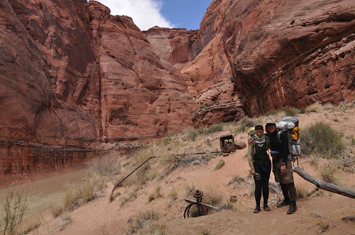
After a couple hours we rounded a bend of the river and saw our first other people since the day hikers near the start of Day 1. It was a father and son team who had started the day before us. They came down the Middle Route. Betty had told us about them and a pair of young girls who started the same day at Wire Pass. We chatted a bit and they took a shot of us at the Judd Pump.
They were going to take 6 days for the trip and I was a bit jealous that we couldn't do it more leisurely as well. I guess we weren't moving all *that* slowly because soon we got far ahead and never saw them again.
I have a question someone might know: If Mr. Judd tried to pump water
from here up to the rim is there a route one can take in and out of the Paria canyon at this point?
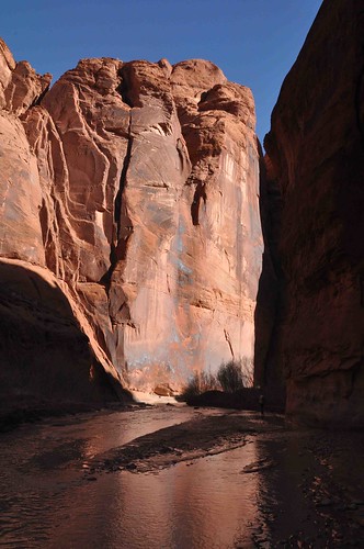
By mid-day the canyon started to open up a bit. The Canyon Wrens had been replaced by Say's Phoebes flycatching from the trees just sporting bright green new spring leaves. Soon we passed into the zone of the next geologic layer; the start of the Kayenta sandstone. Because the Kayenta is more ledgy than the Navajo sandstone we had been in for 2.5 days it let us have a full view of the entire height of Navajo sandstone towering over us. At one place some large blocks of Kayenta sandstone fell into the river and created a chest deep pool. One could either climb the blocks or wade deeply. I choose to wade and Robin climbed. We were getting more proficient at crossing the river and picking the path with the best footing: small riffles are better than flat sections as the riffles mean rocks and flat means sinking into mud.
We found several springs not on the map but then I either missed it or Shower Spring was not really running. I could only find a spot with just a drop every second or two. We had filled up sufficiently that we didn't need it to reach camp at the last reliable spring, but it meant we could not miss that one. It was getting late and still we weren't there. I was 99% sure I knew it was "just one more bend" by noting some particularly shaped twists in the river. But Robin was doubting
me and worried that we should take a camp site we had just passed. I let her rest dropped my pack and scouted ahead. Yep just one more bend. No worries better safe than sorry and soon we were in camp. Again I was wishing we could have had another day for our trip. I felt that after taking on that deficit of miles the first day we couldn't quite enjoy everything the Paria had to offer. We didn't
explore Wrather Arch for instance.
The spring at "Last Reliable Spring" has no pool from which to filter. But as it comes dripping right out of cracks in the rock I risked taking it without filtering. So far so good: we've suffered no ill effects.
 It is good that warriors such as we meet in the struggle of life... or death. It shall be life. - Ten Bears, "The Outlaw Josie Wales"
-
04-10-2010, 11:05 PM #4
Day 4: Tracks on the path less traveled.
The next morning as we continued down river the sun was warming the rocks and I noticed a pair of Ravens using the thermals coming from this enormous turret-like tower of Navajo sandstone. In just a few seconds they gained hundreds of feet with not a single flap of their wings. Soon they were high enough to top out of the canyon. It reminded us of a childrens picture book we read to Aaron called Lizard Sees the World. If you have small kids and want a book with a desert flair check it out.
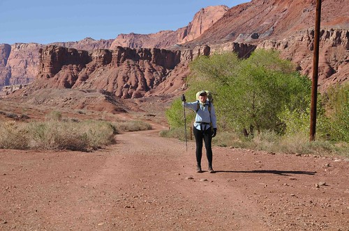
This last day was pleasant and relatively easy. There were no more narrows but the open canyon scenery was lovely and reminiscent of the Grand Canyon nearby. Of course, the rock layers we were in were all much younger (i.e. sit above) all of the Grand Canyon's rocks. Also like the Grand Canyon and the Colorado River, the Paria has cut through its rock layers largely due to the uplift of those layers as opposed to down cutting of the river. Soon we were passing into the Moenave and then the start of the Chinle Formation. The Chinle was especially beautiful here with colors of lavender, blue-grey, dark purple and redish-brown. It is often only a loose packed mud-like formation which erodes into hilly bluffs. When the trail cut
cross-wise over these bluffs it made for tricky footing with potential to slip far down to the river below. But mostly today the trail was blissfully flat and easy.
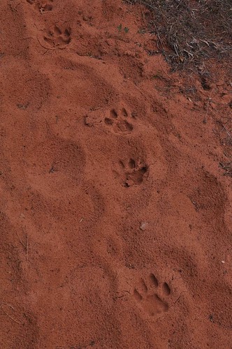
The hard rains the night before last had wiped out all the footprints in the dry sand except those of the two girls walking a day ahead of us. Sometimes we choose the same path they did and other times a different path. While on one such different path we encountered some animal tracks. They were too big for Coyote. Had not signs of claw marks. I'm thinking Cougar, what do you all think?
By mid-afternoon we started to see the final rock layer: Moenkopi which reminded us of our trip last spring to the Maze where the Flint Trail descends through this layer.
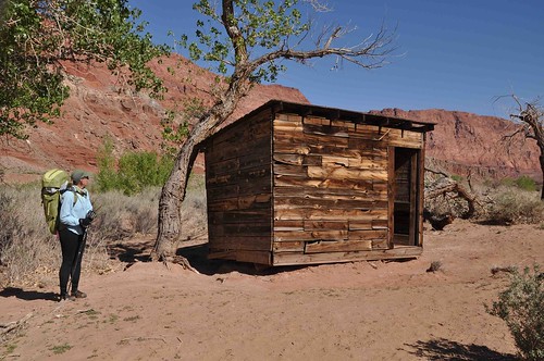
In another hour or so we were passing Emma's Cabin and the Lonely Dell which were both areas of early settlement in the lower reaches of the Paria Canyon. We followed the main trail to the day parking and walked a final stretch on pavement back to our car at the 14 day parking area for Lee's Ferry. It was over. We both felt a sense of accomplishment and fullfilment at having been able to experience the contrasts of the narrow slot of Buckskin and finally finishing with the wide open spaces leading to the Colorado River.
It was definitely one of my top backpacking trips, even though I would have prefered to have an extra day or two. Maybe we'll go back do White House to Lee's Ferry one day with Aaron. I'd also redo Buckskin as a 1 or 2 day trip, but later in the season with drier conditions. I know it pushed Robin a bit beyond her comfort zone but after being home a few days and hearing her describe the trip to her friends it's clear she came away thinking of it as an adventure and not a hardship. Perfect, that means I can plan the next "adventure" :-)
 It is good that warriors such as we meet in the struggle of life... or death. It shall be life. - Ten Bears, "The Outlaw Josie Wales"
-
04-10-2010, 11:46 PM #5
Excellent, excellent, excellent! Great story telling, and fantastic photos!
Judd Hollow Pump: Here's what I wrote in a trip report, based upon what I read in (I believe) Kelsey's book, which I had borrowed from a friend:
So there may have been a route to get down into the canyon upstream a ways, though it perhaps could have been lowered down? I know Kelsey points out a few spots where you can get up & down - even rim to rim at one spot. I'm going to assume that there was a trail upstream...The Judd Hollow Pump was the next major feature, at P17.5. This pump was originally brought into the canyon a mile or so upstream during the 1930s, while the plateau above was undergoing a drought. Folks running cattle above hoped to pump water from the river up to the rim for their herd. Just after the pump was set up, the drought ended, and the pump wasn't used.
In the late 1940s, the owner of the pump sold it to someone else, who moved it downstream by horseback to its present location. It was tested and run in 1949. Never used again. It's been sitting here ever since. I reached here about 2:45 PM, and had some lunch.
Brought back some great memories of this trip - one I'd love to do again! Thanks!
-
04-11-2010, 07:30 AM #6Bogley BigShot


- Join Date
- May 2007
- Location
- We're all here, because we ain't all there.
- Posts
- 19,424
Very well done trip report, thanks for sharing.
And yes Paul, those are cougar tracks.
-
04-11-2010, 01:24 PM #7
 Fantastic trip report!!!
Some people "go" through life and other people "grow" through life. -Robert Holden
Fantastic trip report!!!
Some people "go" through life and other people "grow" through life. -Robert Holden
-
04-11-2010, 05:42 PM #8
Most excellent. Your detailed description and photos makes me want to hit this one and the fact the others have done it on bogley.
-
04-11-2010, 08:26 PM #9
Kev, Kurt, Felicia and accadacca: thanks for the kind words. It's definitely one of those inspirational kind of places.
It is good that warriors such as we meet in the struggle of life... or death. It shall be life. - Ten Bears, "The Outlaw Josie Wales"
-
04-11-2010, 09:25 PM #10

great stuff ststephen!
-
04-11-2010, 11:05 PM #11
-
04-12-2010, 07:04 AM #12
Amazing photos!

Great TR!!
-
04-12-2010, 08:44 AM #13
Awesome report.
-
04-25-2010, 07:47 AM #14
Beautiful!
"Always looking for another adventure"
-
04-26-2010, 03:56 PM #15Yeah - she is lucky! So are you, but I think you already know that! ;)"You know, some husbands take their wives to luxury hotels with spa treatments". I replied, "I know! Poor things. How unlucky they are to miss all this"!
What a great TR & the photos are awesome! I've got to do that canyon!
It looks amazing!!!
-
04-29-2010, 12:08 PM #16
Great TR!
Those tracks are pretty neat. If you look at the main pad in the middle, right below the toe pads, you see a double hump. That means its a cat track. Single is canine.
Cheers!
-
04-29-2010, 03:39 PM #17
Great TR thanks for sharing!

Been drooling over these photos for a few days now.
-
04-29-2010, 10:50 PM #18Ah, that's good to know. I was going on the lack of claw marks as a canine can't retract its claws. It was perfect conditions with the recent heavy rain leaving the sand still moist. Now if I had only got to *see* it...
 Originally Posted by Brian in SLC
I'm honored to finally return the favor as your photos always leave me astounded. Originally Posted by Summit
Last edited by ststephen; 05-11-2010 at 09:48 PM. Reason: fix tag
-
05-01-2010, 01:56 PM #19
WOW makes me want to pack the pack right now! Can you do this trip in June or is it too hot? My wife's never packed and i'd love to get her on this! Any guide volunteers?


 Reply With Quote


Similar Threads
-
Wire Pass to Buckskin conditions?
By MojaveGeek in forum Hiking, Scrambling & Peak BaggingReplies: 7Last Post: 08-26-2010, 07:12 AM -
Lee's Ferry / Glen Canyon Paddling
By tinneyr in forum Boating, Rafting, Kayak and CanoeReplies: 0Last Post: 06-18-2009, 09:56 AM -
[Trip Report] Photos, Wire Pass
By sparker1 in forum Hiking, Scrambling & Peak BaggingReplies: 27Last Post: 03-19-2007, 09:11 AM -
TR: Wire Pass / Buckskin / Paria - March 1-4, 2007
By Cirrus2000 in forum CanyoneeringReplies: 9Last Post: 03-15-2007, 10:38 AM -
[Trip Report] Wire Pass / Buckskin / Paria - March 1-4, 2007
By Cirrus2000 in forum Backpacking & CampingReplies: 30Last Post: 03-10-2007, 09:55 AM
