

Results 1 to 12 of 12
Thread: Freedom Peak Input Needed
-
03-31-2010, 05:07 PM #1
Freedom Peak Input Needed
Have any of you hiked Freedom Peak? I am participating in "On Target" with the BSA, and my troop has been assigned Freedom Peak. I have seen it a million times. In fact I have a pretty good view of it up Rock Canyon from my house, but I have never hiked it. I don't know the best way to get there, how long it should take, how hard it will be, etc.
I found these links:
http://www.summitpost.org/parent/154...edom-peak.html
http://www.mountainzone.com/mountain...sp?fid=3294856
But I was hoping some of you might have some personal experience, to share with me."My heart shall cry out for Moab..." Isaiah 15:5
-
03-31-2010 05:07 PM # ADS
-
03-31-2010, 05:55 PM #2
yep, it's an easy hike up from the road above rock canyon campground. as soon as the road opens up (usually after memorial day.)
-
03-31-2010, 06:05 PM #3
oops, i confused shingle mill and freedom on my last post. after looking at my map, you cut underneath shingle mill and then you have to do some scrambling up a ridge to the summit. not terribly difficult, from what i recall. would be adventurous for the scouts i imagine. good views up there.
-
03-31-2010, 06:06 PM #4
Had my waypoints shown up on the embedded map you would of seen this pic from the cascade saddle looking at Freedom.
ANYWAYS ... Last two times I have been up to the Saddle I have eye balled this scramble that I have highlighted in red.... would not be too bad and definitely shorter then hiking the terraces then ridge line over.
-
03-31-2010, 06:08 PM #5
Mod Hat On!
Hey Summit.... I accidently deleted your first post while deleting your double post.... sorry about that, I'm still trying to figure out all the new controls.
Mod Hat Off
-
03-31-2010, 06:23 PM #6

-
03-31-2010, 06:24 PM #7its all good
 Originally Posted by Iceaxe

re-posting it so beech can tell me what I did wrong.
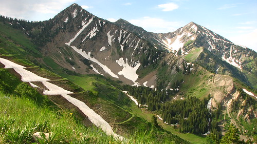
DiscgoDan... The hike up to Cascade Saddle is not bad at all.. but snow can linger in the Cirque well into summer. This shot of Freedom and Provo Peaks was taken from the Cascade Saddle on the 4th of July 2008
Direct link - http://maps.google.com/maps/ms?ie=UT...,0.045447&z=15
-
03-31-2010, 06:27 PM #8
I just typed "freedom peak" and put the map tags around it.

-
03-31-2010, 07:52 PM #9There is a way we can embed SAVED maps, such as uploading kmz's, certain routes and such... But it would be a separate function from the regular map button, we're trying to figure out how to join the two. So for now, sorry, no saved maps are embeddable. If you guys would like two separate buttons, sure, we could get it going. Originally Posted by Summit

-
03-31-2010, 08:48 PM #10separate works for me Originally Posted by Sombeech
-
07-14-2010, 05:44 PM #11
I am going to go up there on Friday with my scouts.
Does anyone have the waypoint for where to start?
How long should I expect the hike to take?
Any final bits of advise?
Thanks."My heart shall cry out for Moab..." Isaiah 15:5
-
07-14-2010, 08:07 PM #12
I am sticking with the route marked in red, you will save a few miles of hiking buy adding a few hundred step yards of route finding... but that's me.
Viewing on a mobile device? Click this link to open the map: http://maps.google.com/maps/ms?source=s_q&hl=en&geocode=&ie=UTF8&hq=&hnear=Provo,+Utah&t=p&msa=0&ll=40.26931,-111.559639&spn=0.019647,0.045447&z=15&msid=116464634257947976353.00048b6429efce7caee62
This photo was taken from the point labeled "photo" on the above map.
I used paint to draw in the routes in the matching colors on the google map.


 Reply With Quote


Similar Threads
-
Need some input on: When God intervenes on your behalf.
By Deathcricket in forum General DiscussionReplies: 74Last Post: 08-17-2009, 10:29 AM -
Teton Freedom Riders movie premiere at Brewvies!!!!!!!!!!!!!
By drboudreaux in forum Mountain Biking & CyclingReplies: 1Last Post: 05-27-2009, 09:53 PM -
Your input needed - Math/Science Teacher Experiences
By Kent K25 in forum General DiscussionReplies: 19Last Post: 08-23-2008, 10:14 PM -
Input needed on a completely unimportant matter
By Kent K25 in forum General DiscussionReplies: 25Last Post: 11-01-2007, 08:08 PM -
Hey man is that Freedom Rock?
By accadacca in forum General DiscussionReplies: 4Last Post: 02-08-2007, 10:28 AM
