

Results 1 to 9 of 9
Thread: Monarch Cave - Ceadr Mesa
-
03-25-2010, 04:33 PM #1
Monarch Cave - Ceadr Mesa
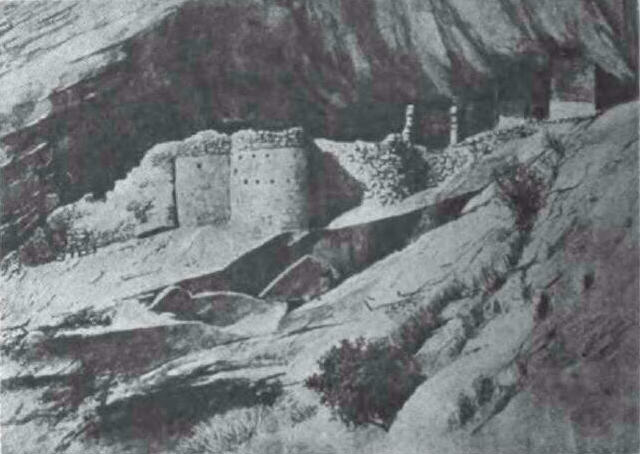
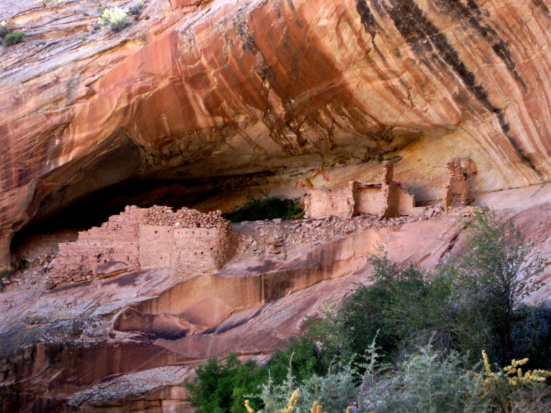
Hey... I found this old sketch of Monarch Cave made by a member of the 1892 Illustrated America Exploring Expedition. Interesting to compare the sketch with a modern photograph.
Monarch Cave 1892
Monarch Cave Today
-
03-25-2010 04:33 PM # ADS
-
03-26-2010, 09:47 AM #2
Wow! That is an incredible sketch.
The man thong is wrong.
-
03-26-2010, 12:42 PM #3
wow, that is neat! I need to see this one!
-
03-26-2010, 01:10 PM #4
Monarch Cave is one of my favorites.... Here is more from the 1892 Illustrated America Exploring Expedition. I've been reading through many of the old journals on Cedar Mesa and just typed up this historical info to add to Climb-Utah.com.
After Mr. Moorehead left us, in one of the deep canyons, about two miles south of Eagle Nest Cave, we discovered one of the most picturesque series of ruins that we had yet seen. It is situated in a beautiful box canyon in the rocky divide between Butler's Wash and Comb Wash, about nine miles south of the Rio San Juan. The canyon is bout half a mile in length, but what a contrast it affords to the monotonous and bare mesa and valleys outside! here instead of of stunted sage-brush, we find a luxurious growth of large, wide-spreading cottonwood tress, giving delightful shade from the hot sun; and beautiful shrubbery and flowering plants, and cool running water. One can appreciate the great difference only after traveling all day on the dry and sandy mesa, where not a drop of water is to be found, and then entering one of these little side canyons, which seem like paradise on earth. One of the large cottonwood trees measured fifteen feet around the base - a wonderful growth for this locality.
Directly to the west end of the canyon, the high sandstone cliff's, with a graceful and undulating curve on their weathered surfaces, close together abruptly, forming a large cavern about one hundred feet from the bottom of the canyon. In this cave are the ruins ruins we are about to describe. From their prominent position they command the valley, and their curved fronts, cut with dozens of loopholes, give the effect of a modern fortress. We named it Monarch's Cave, for it must have been monarch of all it surveyed.
The cavern was thirty-five feet in height at the front, and fifty-seven and three-fifths feet deep, forming an excellent stronghold and a perfect shelter. It is only accessible on the north, and then only by using the ancient footholds which have been cut into the slanting sandstone ledge. As many of these have been worn away, it is with no little difficulty that one gains the entrance into the cave. Directly under the mouth, at the bottom of the canyon, and almost hidden by shrubbery, is a large excellent spring of clear, cold water, measuring thirty feet across and having a depth at the center of four feet. Such a source of water was of extraordinary importance to ancient dwellers in the cavern. It not only supplied them with water, but also irrigated the canyon for the cultivation of their crops. At the back of the cave water trickles down the ledge of rock causing a thick growth of hanging ferns and creeping vines, adding much to the beauty of the place.
Judging from the large number of loopholes in these ruins, the structure was evidently intended as a fortification. In one room alone we counted twenty-five loopholes. From these the defenders could send their arrows in every direction, up or down the canyon. The front walls of the prominent rooms are all rounded, so that by means of the loopholes the whole canyon below could be commanded. The entire entire aspect of the cave is of defense and protection rather than comfort.
.
-
03-27-2010, 09:03 PM #5Bogley BigShot


- Join Date
- May 2007
- Location
- We're all here, because we ain't all there.
- Posts
- 19,424
Uh--about 9-miles North................... Originally Posted by Iceaxe

-
03-27-2010, 09:11 PM #6Yeah, I noticed that... what I posted was the direct quote from "The Field Diary of an Archaeological Collector" by Warren K. Moorehead. The book is avaiable on-line for free from Google Books. Originally Posted by oldno7
Link to Book:
http://books.google.com/books?id=Hgg...age&q=&f=falseLast edited by Iceaxe; 03-27-2010 at 09:22 PM.
-
03-27-2010, 10:56 PM #7
Fascinating read as well. Not having been there, is the foliage still as described? It's also interesting to see that apparently one of the walls has fallen. Thanks for sharing this!
It is good that warriors such as we meet in the struggle of life... or death. It shall be life. - Ten Bears, "The Outlaw Josie Wales"
-
03-28-2010, 06:42 AM #8Bogley BigShot
- Join Date
- May 2007
- Location
- We're all here, because we ain't all there.
- Posts
- 19,424
Yea, Sorry about my screwed up quote. It combined his and yours. Originally Posted by Iceaxe
I've never been there when any foliage was on, But I've been there in Dec.-Jan.
-
03-28-2010, 01:17 PM #9 Originally Posted by ststephen
I think the side canyon Monarch Cave is in remains pretty much as it was found. But Butler Wash is now clogged with tamerisk which would be a huge surprise to the first white eyes that uncovered the place. I also wouldn't have called the pool of water cold and clear. It looked a little stagnet with what appeared to be a small oil slick floating on the surface.
As for the fallen wall.... my guess is that is the result of the early archeologist and pot hunters.Last edited by Iceaxe; 03-28-2010 at 01:20 PM.


 Reply With Quote


Similar Threads
-
The Grand Mesa
By Scout Master in forum Hiking, Scrambling & Peak BaggingReplies: 4Last Post: 09-10-2008, 10:21 PM -
Cave Survey Approves Public Dissemination of Cave Locations
By jumar in forum Climbing, Caving & MountaineeringReplies: 1Last Post: 05-15-2007, 12:01 PM -
[Trip Report] Monarch Cave Ruins
By Iceaxe in forum Rock Art & RuinsReplies: 1Last Post: 06-12-2006, 09:32 AM -
[Trip Report] Fish Mouth Cave - Cedar Mesa
By Iceaxe in forum Hiking, Scrambling & Peak BaggingReplies: 4Last Post: 06-08-2006, 07:35 AM -
FWD: Darby Wind Cave/Fossil Mountain Ice Cave Incident
By caverspencer in forum Climbing, Caving & MountaineeringReplies: 2Last Post: 12-10-2005, 09:21 AM
