

Results 21 to 36 of 36
Thread: Cedar Mesa
-
05-15-2009, 04:34 PM #21
Scott.... I appreciate your suggestions... but for the most part you are just giving me areas to hike in... I know the areas. What I really want is to know is where all the goodies are at.

Now if you want to PM me directions to the Green Mask that would be cool.
Big Man Pictograph, Three Fingers Ruin and Hotel rock I already have beta.
So I'm thinking Seven Kiva and the Citadel one day. Maybe Lewis Lodge and the Doll House the second day?
I'd be happy to swap the Citadel for something else in the area. maybe something else out Road Canyon way?
Anything else up by Lewis Lodge? Anything else near the Doll House I should be stopping to see while I'm out that way?

-
05-15-2009 04:34 PM # ADS
-
05-15-2009, 08:49 PM #22I do not know alot about the ruins in this area but I do know you will not want to take your truck from arch canyon to hotel rock. If you do I want to come watch. That is a decent jeep trail. We were suprised.
 Originally Posted by Scott P
Mark
-
05-15-2009, 09:44 PM #23So what you are saying is we will have no problem making it all the way in a rental car...... Originally Posted by moab mark

-
05-16-2009, 12:53 PM #24No real destinations near the Doll House or Lewis Lodge. Lots of little stuff that is pretty ordinary. Originally Posted by Iceaxe
The gostak distims the doshes.
-
05-19-2009, 05:56 PM #25OK, so how do you go about finding the Fortress in Fable Valley? Originally Posted by bobb169
And exactly how do you hike Fable Valley. I was just looking at the USGS map and it looks like a trail runs all the way through with a TH on both ends.
More info please....

-
05-19-2009, 09:12 PM #26
I went to Fable years ago, from the top, drove my modified Jeep down a washed out road to the corral, then camped and hiked down in the morning. As soon as I hit the wide end of the valley you could see several ruins in their alcoves across the valley way. I saw a large black bear on the trail in there. I just hiked to the spring and around the ruins and back. I am not sure which one is the fortress.
Any way some friends of mine went there just last year and swear they were stalked by a large black bear.
For some reason I find that area kinda creepy. I won't be back, although quite beautiful.You can rest when you're dead
-
05-19-2009, 10:54 PM #27
Assuming you know how to get into that country...come off of Longs Point Rd on the Sweet Alice Rd. Go along it to the Fable Valley TH (N37 51.674 W109 58.779). Last year the road has got pretty rough and you can only go down it about 1/2 mile so park at the top. Total to hike to the fortress is about 3.5 miles. Fortress is at (N37 53.978 W109 58.052) Along the way you will spot others, the open flat is covered with potshards and ruins. It evidently was a large community. Go on past the Fortress and watch there are other ruins and petroglyphs. The Fable Valley Spr is very good water. This canyon the trail goes back up to the Beef Basin Rd. Go on past the spr about 3/4 mile and there is a ruin high up in the cyn to the west. Not much else past here. Keep on going and you end up in Gypsum Cyn and to the Colorado river, this is a cool hike, did it about 10yrs ago and floated down to Bowdie Cyn and hiked back up to the Sweet Alice Rd. If you go to fable valley also take the time for the Bowdie Cyn ruins, they are worth it as well.
Yes there are Black Bears, we ran across one in Gypsum Cyn. Also they graze cattle in Fable Valley. The road across Longs Point has one place where there is a hugh snowdrift that melts late.
You can PM me for the GPX track.
-
05-20-2009, 06:35 AM #28Bogley BigShot


- Join Date
- May 2007
- Location
- We're all here, because we ain't all there.
- Posts
- 19,424
Incredible stuff-----Thanks Bob
-
05-20-2009, 08:17 AM #29
Thanks for the info.... you guys are awesome.
-
05-20-2009, 09:09 AM #30
Nice Bobb, another item just got added to my list.
The gostak distims the doshes.
-
05-20-2009, 09:57 AM #31
OK.... I think I have one day of our trip dialed in. Thanks to the many suggestions from Bogley members I think we are going to try a down Sheiks Canyon and up Bullet Canyon loop. It will be a long day but it looks like we will get to visit really a lot of awesome stuff.
One question... what is the water quality at the springs along my route? Do I need to pack a pump? Or can I just tab the water? In other words, do the springs emerge from a wall or am I getting it out of a pool?
Now time to start figuring out day two....
-
05-20-2009, 05:04 PM #32The "springs" were stagnant pools on our visits. Kind of a swampy taste. Bring a filter.One question... what is the water quality at the springs along my route? Do I need to pack a pump? Or can I just tab the water? In other words, do the springs emerge from a wall or am I getting it out of a pool?
-
11-04-2013, 09:13 AM #33
Bringing back this old thread.
There was a little discussion on approaching Hotel Rock from the North. Can anyone comment on that, wondering if anyone knows how things have changed in the past 4 1/2 years.
-
11-04-2013, 11:07 AM #34It's the same road that takes you to Lewis Lodge, when you hit the Lewis Lodge trailhead just keep driving an additional 4 miles. The road is a true 4x4 road. A stock jeep or 4x4 truck will have no problem, Subaru's and station wagons that some refer to as SUV's will not make it. Originally Posted by hike.higher

Lewis Lodge Route Description
http://climb-utah.com/CM/lewis.htm
-
11-04-2013, 07:15 PM #35
Thanks. Was planning on Lewis Lodge already and hoping to stretch it to Hotel Rock. I'll give it a try.
-
11-07-2013, 12:45 PM #36
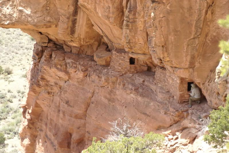
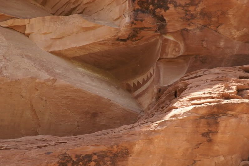
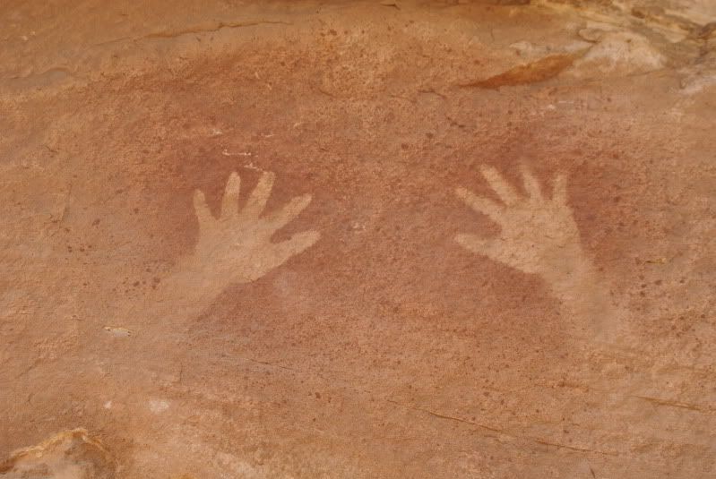
That is some crazy/great rock art!
Keep your lens clean and your mind open


 Reply With Quote


Similar Threads
-
Cedar Mesa Warning
By Iceaxe in forum Hiking, Scrambling & Peak BaggingReplies: 7Last Post: 04-09-2010, 03:06 AM -
[Trip Report] Seven Kivas - Cedar Mesa
By Iceaxe in forum Hiking, Scrambling & Peak BaggingReplies: 2Last Post: 05-27-2009, 11:30 AM -
Cedar Mesa Question?
By dandyj in forum CanyoneeringReplies: 5Last Post: 06-23-2008, 09:40 AM -
cedar mesa sept 30
By denaliguide in forum Backpacking & CampingReplies: 5Last Post: 09-26-2007, 04:09 PM -
[Trip Report] Cedar Mesa
By psl53 in forum Hiking, Scrambling & Peak BaggingReplies: 5Last Post: 02-27-2006, 09:19 PM
