

Results 61 to 74 of 74
Thread: HITR - January 09
-
01-27-2009, 04:08 PM #61Yes, I agree. I was refering to the motorized OHV/ATV track/road as being a recent creation, not the Devils Racetrack itself and was speaking about motorized roads. It was indeed a cattle trail used as far back as the 1800's and the amount of pictographs along the route and in the area indicate that it was a well used route long before that.Not true.
Devils Race Track has been used since 1875. It was first discovered by Joe Swasey and most likely his three brothers. Devils Race Track was used to move livestock and people from Ferron to the Head of Sinbad. Wheeled vehicles have been using this trail prior to 1900. The family of Joe Swasey has a picture of him in a horse drawn carriage (with four wheels) going down Devil's Race track prior to 1900.
At least into the 1980's the Devils Racetrack was still a cattle trail and to my knowlege was not a motorized route before then, at least not visibily. Does anyone know of it being used for motorized vehicles prior to that? It didn't have any signs of being used a such in the 1980's, but I'd be interested to know if anyone else knows differently.
-
01-27-2009 04:08 PM # ADS
-
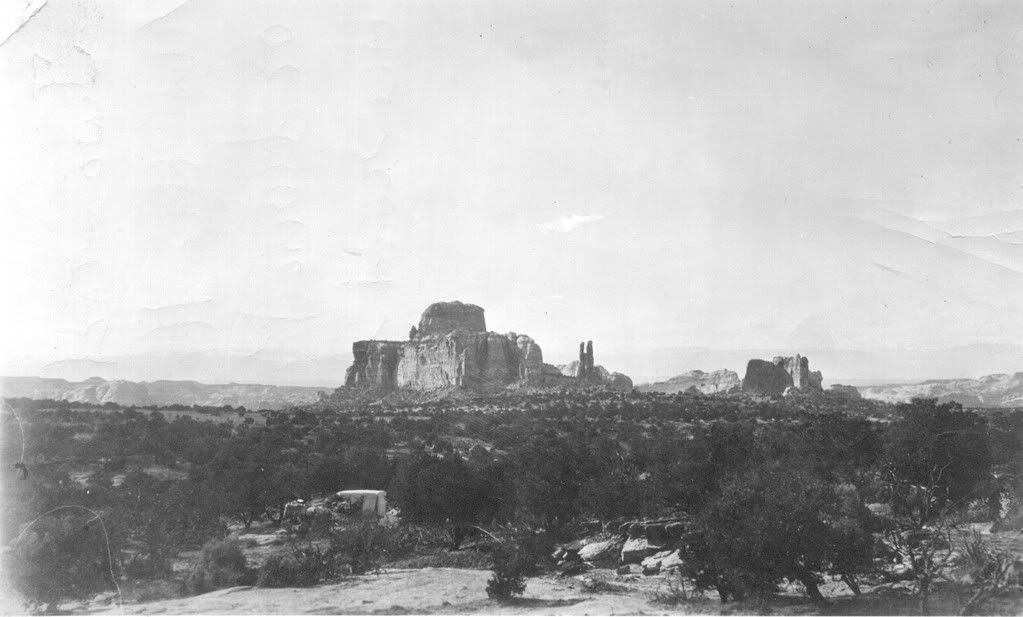
01-28-2009, 08:41 AM #62The Devils Racetrack was used as a wagon route as mentioned earlier. If you look at the attached picture from the Swaseys, you will see the wagon and the Twin Priests int he back ground. Since it was used as a wagon route-4 Wheels and over 60" wide, there were improvements made to the route to accomodate this.Yes, I agree. I was refering to the motorized OHV/ATV track/road as being a recent creation, not the Devils Racetrack itself and was speaking about motorized roads. It was indeed a cattle trail used as far back as the 1800's and the amount of pictographs along the route and in the area indicate that it was a well used route long before that.
At least into the 1980's the Devils Racetrack was still a cattle trail and to my knowlege was not a motorized route before then, at least not visibily. Does anyone know of it being used for motorized vehicles prior to that? It didn't have any signs of being used a such in the 1980's, but I'd be interested to know if anyone else knows differently.
The earliest documented travel of the Devils Racetrack by a motorized vehicle was in the 1940's when a tractor was driven over it by a man from Ferron. I don't think the route has ever been bulldozed, but there was a bulldozer driven over the route in the 1950's. There are places where you can still see track marks in the stone.
And if you have any understanding of RS2477, you would know that the Devils Racetrack is a RS2477 route and for it to be it had to be used prior to 1976. So for you to say prior to 1980 it was just a trail just does not add up.
-
01-28-2009, 04:34 PM #63Thanks. Actually, that's the info I was looking for and why I phrased it in the form of a question and if anyone knew of it being used (motorized) before then. PS, where did you find the photos?The earliest documented travel of the Devils Racetrack by a motorized vehicle was in the 1940's when a tractor was driven over it by a man from Ferron. I don't think the route has ever been bulldozed, but there was a bulldozer driven over the route in the 1950's. There are places where you can still see track marks in the stone.
Yes, I know it is a claimed RS2477 route (which is why I asked about the history and am glad you were able to provide it), but almost everything that has ever seen any kind of wheel and sometimes even trails that haven't are also made as RS2477 claims, so it's always good to ask.And if you have any understanding of RS2477, you would know that the Devils Racetrack is a RS2477 route
For example (feel free to check), Quandary Canyon is also a nearby RS2477 route:
http://www.canyoneeringusa.com/utah/swell/quandary.htm
The reasoning behind this one being a RS2477 "road" is because the Atlas Corporation actually did get vehicles into the upper end back in the 1950's. Now days you have to use ropes to access the old drill hole.
-
01-28-2009, 06:31 PM #64
quote]
where did you find the photos?[/quote]
The photo came from the Swasey family.
A friend of mine has spent a lot of time gathering history on the San Rafael Swell. He has spent a lot of time documenting the locations of many of the old cowboy camps, and history of the Spanish Trail, army routes, etc.
If you look around, there is a lot of cowboy "grafitti" within close proximity and sometimes right over the top of indian "grafitti". Have you ever wondered who these people were? There are some very interesting stories behind some of the names you find out there.
RS2477 dates back to the late 1800's and really has nothing to do with "wheel travel". I believe it was around 1866 it was established by congress to give rights of way across public land. The rights were given to counties. The counties hold those rights of way unless they relinquish them. As you can imagine, there were not motorized vehicles back then, so it only has to do with rights of way, not the mode of transportation.
but almost everything that has ever seen any kind of wheel and sometimes even trails that haven't are also made as RS2477 claims, so it's always good to ask.
-
01-28-2009, 08:20 PM #65I know who many of them were and many of the stories; just not the motorized history of the route in question.Have you ever wondered who these people were? There are some very interesting stories behind some of the names you find out there.
Anyway, yes I'm pretty familiar with many of the names out there (Sid and Joe Swasey, Garvins, etc.) and some of the foklore/history. I also know the history behind naming features such as Joe and His Dog, Baptist Draw, Old Woman Wash, Sids Mountain, Spotted Wolf, Walker Trail, Reds Canyon, and of course the famous well known stories on places like Sids (Swaseys) Leap etc. I like finding the old glyphs out there.
If interested, I also worked at Camp Evergreen in the Uinta Mountains 1990-1991 with Mike Swasey. If I remeber right it was his great grandfather that built the Swasey Cabin. We used to work at the camp during the week and during the weekends sometimes used to climb the mountain peaks together (Bald Mountain and Reids Peak for example).
During 2001-2004 I was also with neighbors with the Chaffin's in Fruita whom are decendants of the ones that built the Chaffin Cabin along the San Rafael River, but far down river from the Swell itself. Before the cabin burned down they collected many of the artifacts and they decorated their house with them. We were friends and at dinner at their house a few times and we went to the same church. They told us a few stories.
I've also seen many of the glyphs made by old cowboys and outlaws out there when wandering the Swell.
Yes, it was 1866 and was part of the Mining Act with the original intention to give access for miners to their claims. In 1976 the law was repealed and highways over public lands that existed before 1976 were meant to be grandfathered in.I believe it was around 1866 it was established by congress to give rights of way across public land.
What constitutes a highway and the intentions of the law seem to be the #1 arguement between the Feds versus the Counties or State (or vs the states in some cases) or on this thread say the wilderness advocates vs the ones who don't want the wilderness.
Taking that one step farther, if interested the county I live in (Moffat County CO) claims that the Yampa River itself is a RS 2477 claim as well as the old indian trail up the draw on the just to the east of Dinosaur National Monument next to the Skull Creek Basin. The later has an 8-foot drop in the middle of the draw. The hiking trail up Cross Mountain is also a RS 2477 claim.As you can imagine, there were not motorized vehicles back then, so it only has to do with rights of way, not the mode of transportation.
Personally, I don't think the Counties, States, Feds or user groups will ever agree on what a legitimate road or highway is.
================================================== ===============
Anyway though,
I'm fasinated with the Swell history if you ever want to chat about it sometime. I'd be happy to tell you about some of the old glyphs and ruins I've found just out wandering.
Once while climbing some of the buttes well east of the Swell I found an old register on top. Last signature was from 1911. I swore that one to secrecy, but all other's I'd be happy to share.
-
01-28-2009, 10:00 PM #66
Great Swell history guys, I'm also a Swell history buff, don't claim to know much but I'm trying to change that. With each trip to the area I find something neat and new.
Back to HITR:
I spent some time on the phone today with Brian Sweatland, the rec planner for the GCNRA. We had spoken almost a year ago about the Rincon Trail and I wanted to follow up with him on the progress.
1. The Rincon Trail is closed, just as it has been since at least 1979 when their last management plan was devised, the history between 1979 and the earlier creation of the park isn't 100% clear though I didn't spend much time asking, its kind've moot. The reasoning behind the closure isn't quite clear either, Brian is relatively new to the area, so he's just trying to catch up on 40 years of policy. They have been asked by the county (who is claiming this as a potential RS2477 claim) to revisit the decision on this route but is a low priority given all the other disputed routes that the feds and the county are debating. Until that ever happens (and thats if it ever happens) its considered closed to all motorized travel by the GCNRA and they can and have ticketed.
2. Non street licensed vehicles in the GCNRA. Their policy on this is firm, with the exception of the one play area, once you hit GCNRA property you are to be street licensed, this can be a full size vehicle, a ATV or dirtbike that has gone through the process. This is why there was a big push by the OHV community a couple years back to allow street legalization for OHV's, it seems the counties knew their RS2477 claims could not trump the use classifications of the jurisdictions of these areas (GCNRA, Canyonlands National Park, Uinta National Forest, etc.). Again they can and will ticket for this.
We resumed our chats about doing a run from Bullfrog so that Brian can see the recreational value of the entire HITR trail, particularly the Rincon. We are going to resume talks about this in the coming weeks and additionally we are going to chat about getting some qualified user comments on the HITR and Rincon trails to help him push the issue within the NRA administration. I'll keep everyone posted (yes even you Reedus ) if/when we are ready for comments.
-
01-29-2009, 05:39 AM #67
You da man Kurt. Let me know the when and where.
-
01-29-2009, 05:45 AM #68
-
01-29-2009, 05:52 AM #69
-
01-29-2009, 05:54 AM #70
-
01-29-2009, 05:56 AM #71
-
01-29-2009, 05:59 AM #72
-
01-29-2009, 09:49 PM #73Carbon Footprint Donor


- Join Date
- Jan 2007
- Location
- In Nothing But Sunshine
- Posts
- 8,849
Those things are cool

-
02-06-2009, 10:21 PM #74
Brief update. I spent a few minutes on the phone with a San Juan County commission this last week. He is working on some of the county's road claims and I'm optimistic that the info I provided him might help get the Rincon "back on the map" if you will. I'll keep you posted Reedus


 Reply With Quote


Similar Threads
-
[Trip Report] JEM Trail January 2010
By Sombeech in forum Mountain Biking & CyclingReplies: 11Last Post: 02-04-2010, 04:19 PM -
Looking for Info on Escalante (S HITR), Powell, or Reef...
By AJ in forum CanyoneeringReplies: 0Last Post: 05-14-2009, 09:16 PM -
New AC/DC album in January 2008?
By Sombeech in forum General DiscussionReplies: 1Last Post: 08-03-2007, 01:57 PM -
[Trip Report] Little Sahara in January
By MTpockets in forum Offroad 4x4, Side by Side and ATVReplies: 14Last Post: 02-19-2007, 12:02 AM -
[Trip Report] TR: Mount Olympus in January
By Glockguy in forum Hiking, Scrambling & Peak BaggingReplies: 2Last Post: 01-07-2006, 12:18 PM
Visitors found this page by searching for:
Outdoor Forum
