

Results 1 to 10 of 10
-
08-13-2007, 10:23 PM #1
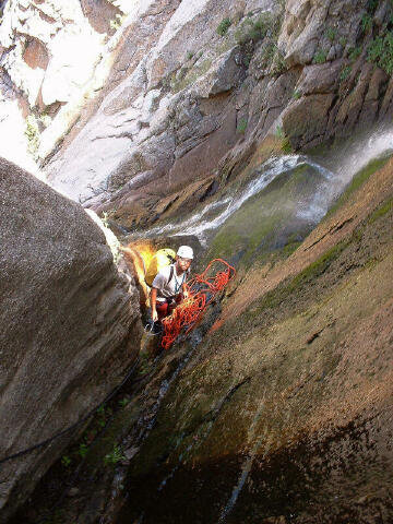
BETA - Stairs Gulch, Wasatch Mountains
Stairs Gulch - Big Cottonwood Canyon (Wasatch Mountains)
Rating: 3B II
Season: Summer and early Fall. Usually doable sometime in July until the first snows stick (usually late September to October)
Rope required: 150 feet to be safe. If anyone measures the drops let us all know how long they are. Longest rap is probably less than 50 feet, but bring a longer rope just in case.
Rappels: Three, less if you are really brave, go last at the slide, or bypass the first waterfall.
Water Protection: Shortee's in the fall. Shortee's in summer if you like playing in the water (the water is freezing on the slides even if it's hot outside). I've done it in September with a shortee, very enjoyable. I did it in July without a wetsuit and only did half the slides I did in September because the water is painfully cold if you get submerged. You never HAVE to submerge yourself, but if you like playing in the water or want to body belay on the optional rappels, a shortee makes it more enjoyable. Wetsuits aren't needed in Summer though.
Main draw: It's close to Salt Lake, with fun downclimbs (rappelling is NOT the main draw), flowing water, and the first rappel is actually pretty nice.
So here you all go, some beta for what tuns out to actually be a pretty fun little canyon. It's short, it's shallow, and it's not southern Utah but it sure feels like canyoneering and is a great way to cool off on a hot summer day in the valley.
To get there drive 2.9 miles up Big Cottonwood Canyon to the Stairs Gulch trail on the right (looking up canyon - LUC) side of the road (just across the street from the Storm Mountain Picnic Area). From here there is a wide, well maintained trail that mountaineers use to access Twin Peaks and climbers use to access countless climbs in the area. The maintained trail ends in 1/2 mile, but the social trail forged by mountaineers continues generally on the left side of the stream, crossing every now and then to avoid cliffs.
After climbing the endlessly steep gulch you come to a section where bluish colored cliffs form a wide v-shaped slot that the creek cascades down. This is the end of the canyoneering route. Another landmark is a very small stream coming in from the right (LUC). From here you have two choices, neither is really pleasant. Choice A is to upclimb the wide slot doing two sketchy scree covered traverses above waterfalls, be very careful not to slip on these. Second choice is to claw your way up the left side (LUC) of the gulch and bushwhack along the tops of the cliffs, following the rim of the "slot". With good routefinding you can keep the bushwhacking to a minimum, but you will still get your share (views of the small waterfalls below from this route are nice).
No matter which way you choose to go, before long you will come to a split in the stream. About 3/4 of the water comes from the right fork, and 1/4 comes from the left. If you look up the left you will see a shallow, but interesting looking "slot", this is the main attraction. This section can not be easily upclimbed so the best way to go is to climb the slabs in between the two forks of the stream, gradually making your way to the rim of the "slot" on the left (LUC). Once reaching the rim, follow it until you find an easy place to downclimb into the "slot". Once in the slot, hold off your desire to suit up and start down, look up canyon and you can see a waterfall dropping in just above you. This is an optional rappel, but is the nicest of the canyon, so you really shouldn't miss it. It's a short day, might as well add a little to it. Climb a narrow couloir to the right of the waterfall (LUC) and then make your way to it's top. We anchored off a rock and went down the watercourse. Enjoy the water on your feet and then get on to the business.
After the first waterfall you will have countless downclimbs thrown at you. The rock is slippery so be careful, you don't have nearly as much friction on this quartzite as you do on sandstone so adjust accordingly. After some good downclimbs you will come to a sloping 10 foot waterfall. Some will want to rappel this drop. The waterfall can be slid down but you should send at least one person down on the rope (using a body belay) to clean up rocks at the bottom. The landing area is only a few inches deep and rocks on the butt hurt. There is an old rusted piton on the right (looking down canyon - LDC). Use it to rap off at your own risk (I didn't trust it).
More downclimbs bring you to another long drop, this one possibly could be downclimbed, but that rock is slippery and it's a long fall if you don't make it. Could be fun to downclimb while on belay. We anchored off a jammed rock above the drop.
After this rappel the canyon starts to ease up, a few more downclimbs bring you to the fork in the stream you passed on the approach. Below here are some short but fun slides and optional rappels. It is probably best to body belay these (most will be in the water so this is best done with at least a shortee on) so you don't leave webbing where it's not needed (everything can be downclimbed or bypassed).
A word of caution, most signs in Big Cottonwood Canyon say no swimming or bathing in streams or lakes in the watershed. Although we are technically not swimming or bathing, I doubt the sheriffs office would look to highly on playing in the water up there. Go at your own risk. Have fun.
Link to video:
http://video.google.com/videoplay?do...249&q/#0h7m53s
Eric.
-
08-13-2007 10:23 PM # ADS
-
08-14-2007, 02:41 PM #2
Cool Thanks! I would like to try this out - we may check out Rocky Mouth Canyon this weekend just cause it is close...
-
08-14-2007, 02:43 PM #3
I'd like to do Rocky Mouth again just to get some cool pictures.
The Great White Icicle is also a fun way to spend a hot summer day around the Wasatch.

-
08-14-2007, 02:50 PM #4
Looks pretty sweet. thanks for the beta. How long is it (miles) or how long did it take you to complete.
The man thong is wrong.
-
08-14-2007, 03:51 PM #5Ummm... the approach hike I'm sure is less than two miles each way, but it's consistently steep and the scrambling/bushwhacking slows you down a little. Car to car, 4 or 5 hours. The first time I did it was an evening, after work thing, started around 3:30 - 4:00 if I remember right, got done around 8:00. I've had to make anchors both times I've done it. This year our webbing had been ripped out during spring snowmelt. I went through in July so everything should be there still, might want to bring 30 feet or so of webbing just in case.
 Originally Posted by Jaxx
Eric.
P.S. Give us a TR if you do it, I'd like to know what others think of it. I think it's a lot of fun, always curious if others think it blows. If rappelling is your main draw to canyons you will probably like Shane's Great White Icicle route better, if you like downclimbs you'll like this one.
-
08-15-2007, 06:48 AM #6Sounds like there was a rock slide up at GWIThe Great White Icicle is also a fun way to spend a hot summer day around the Wasatch.
http://www.utahclimbers.com/phpBB2/viewtopic.php?t=2058
-
08-15-2007, 06:56 AM #7Ya, by the look on Hank's face, I'd say he was having the time of his life... Originally Posted by Iceaxe
It's only "science" if it supports the narrative.
-
08-17-2007, 04:28 PM #8
Here is a longer video from our first descent last September. The copy on my HD was crap so the online video is kind of crap too. Enjoy:
[youtube]http://youtube.com/watch?v=BJhBElDJgRM[/youtube]
-
08-17-2007, 08:48 PM #9If ya ever met Hank you would know that is his happy face. Originally Posted by rockgremlin

-
08-18-2007, 07:33 PM #10
pretty cool !
signature


 Reply With Quote


Similar Threads
-
[Beta] Grand Gulch/Shaw Arch Beta
By ddavis in forum Hiking, Scrambling & Peak BaggingReplies: 15Last Post: 10-26-2010, 07:22 PM -
Take the Stairs
By Last Child in forum General DiscussionReplies: 0Last Post: 11-12-2009, 02:26 PM -
Stairs, don't fall up them.
By Sombeech in forum General DiscussionReplies: 10Last Post: 11-04-2008, 06:44 PM -
[Beta] What's the best book about hiking in the Wasatch Mountains?
By Wasatch Rebel in forum Hiking, Scrambling & Peak BaggingReplies: 9Last Post: 06-30-2008, 01:41 PM -
Dan falls down stairs - video
By Sombeech in forum Mountain Biking & CyclingReplies: 8Last Post: 06-18-2007, 09:40 PM

