

Results 1 to 13 of 13
Thread: Mill Creek Canyon this Saturday
-
06-14-2007, 02:59 PM #1
Mill Creek Canyon this Saturday
I am looking for a "local" 6-7 hour hike to do Saturday afternoon starting around 11am or Noon. Somewhere in Salt Lake or Utah County..
I was thinking of heading up Mill creek to a few of the peaks like Gobblers Knob and/or Mount Raymond. Lots of places up there I want to see.
1- Would anyone like to join me, or have have another saturday afternoon hike planned I could possibly tag along on?
2- Can someone point me to a good page about the trail system up Mill Creek so can plan my route better?
This is about the best thing I have found so far http://www.fs.fed.us/r4/wcnf/unit/sl...n_trails.shtml I guess what I would like to see is a map with the trails on it.I'm not lost... I'm just GeoCaching
-
06-14-2007 02:59 PM # ADS
-
06-14-2007, 03:30 PM #2
Looking at the topo maps I would probably take the Bowman Fork Trail. It looks like it puts you at the base of Gobbler's Knob. I've kinda traced it out here:
http://www.gmap-pedometer.com/?r=1048391
Note: I've never actually done this hike, so take my advice (and map reading skills) with a giant grain of salt.
I don't think I have anything planned this Saturday, so I might be able to join you.
Edited to use new route URL
-
06-14-2007, 03:33 PM #3
i just came across this cool link when looking for a wasatch area map i was gonna suggest to you.
the map i have i got at REI and it's a nice illustrated map of the Wasatch front. it was only a couple bucks. the maps that they give away at the toll booth suck, so dont count on those.
-
06-14-2007, 03:43 PM #4
Bah! Gmap Pedometer didn't save my new route, and instead has an old route. Lemme try that again:
http://www.gmap-pedometer.com/?r=1048391
Although, after reading the description on UtahPictures.com the Alexander Basin route might be a better option. The switchbacks on Bowman Fork between mile 1 and 2 look like they're probably a bitch.
-
06-14-2007, 05:11 PM #5
Never done Gobbler's Knob from MillCreek, but you will end up at Baker's Pass and then either you go left to Gobbler's or right to Mt. Raymond.
-
06-15-2007, 01:08 PM #6
 Originally Posted by kris247
Kris (and anyone else who might want to go) send me a mesage with your number and I will give you a call or just give me a call in the morning around 9:30am. My cell is 801-381-0839
My sons baseball game (that I coach) is from 8 to 9:15am so around 9:30am I will know what is going on for the day.
I have a tiny bit of time right now to look at maps and decide the route. If we have 2 vehicles we could make a nice loop and cover a lot of ground.I'm not lost... I'm just GeoCaching
-
06-15-2007, 01:38 PM #7
PM Sent.
I just called Salt Lake County Parks and Rec, and they say that the winter gate is open. So, it shouldn't be a problem driving to the Alexander Basin and Bowman Fork trailheads. (Parking, on the other hand, may be an issue).
-
06-15-2007, 03:14 PM #8
If I can get the image to work.....
Here is an Idea of a route I would *like to take.
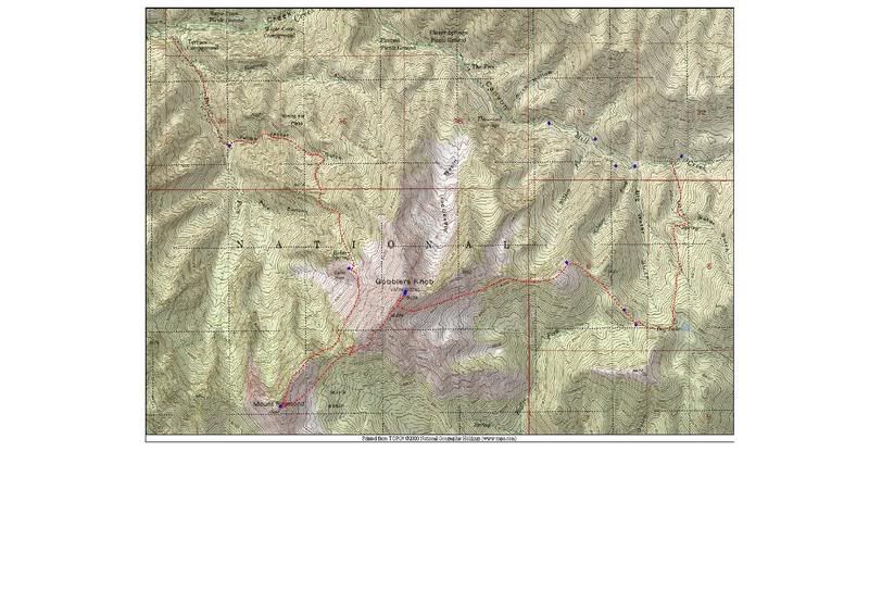
However it is about 9 1/2 miles on paper. And a total elevation gain of 3600' including dropping down from Gobbler to the saddle then 1000' feet up Raymond.
So they way I see it (starting from the top of Mill creek) is 10 Miles / 2mph = 5hours PLUS 3600'/ 30min per 1000' = 2 more hours so 7-8 hours total.
Thats packing a little much in considering we wouldnt get started until 11 or Noon.
I will have to take another look tonight, but reality is there will probably only be time to go to Mount Raymond and Gobbler.I'm not lost... I'm just GeoCaching
-
06-15-2007, 03:27 PM #9
Yeah, I can't be out that long tomorrow - I've got other planned for Saturday evening. Let me know what you figure out, and I'll let you know if I can come along. :)
-
06-16-2007, 10:19 PM #10
Kris my apoligies I took off without writing down your number.
Turns out the upper is gate is still closed (sign says it opens July 1).
Something about hiking up pavement does not appeal to me, So I ended up parking at the terraces and heading up to gobblers knob via bowman fork. Round trip took 7 hours and I had to leave Mt Raymond for another day.
Here is my log entry on the Gooblers Knob cache at geocaching.com
June 16 by caverspencer (2459 found)
ah what a day!!!! I had spent the week studying maps and had a nice loop planned out to get this and Mt Raymond and a few Mockba caches all in a 9 mile loop. well when I arrived at the closed gate high in millcreek (it opens July 1) I had to resort to plan B. There is just something about hiking up a paved road that doesn't appeal to me. So down the Terraces trail head I went. Certainly not the easiest approach.
My log entry in the geocache log book goes something like:
"Wow what a hike, Great view from up here. Came up from the Terraces trailhead its now 5:28pm and its taken about 5 hours so far, and i think that gate closes at 9pm. Wish I could stay longer but I better run, i will have to save Mt Raymond for another day"
Well as it turns out I had plenty of time. It was 8:10 pm when I turned on my phone at the mouth of Mill Creek. If I would have known I would make it down that fast i would spent 30+ minutes taking in the view instead of 10. That's ok i will back!
What a great hike though! Thanks for giving me a reason to come up here Stan.I'm not lost... I'm just GeoCaching
-
06-17-2007, 05:27 AM #11
No big deal. Sorry about the bad info about the winter gate, but that's what the SLCO Parks & Rec people told me when I called. Obviously a government operation. ;)
Sounds like a good hike - I may hit it next weekend.
-
06-17-2007, 06:16 PM #12
FYI I Just saved my track log.
Lowest elevation 6253, Highest Elevation 10,262
total time 7:18 Average overall speed 1.3 mph Total distance 9.52 miles.
I havent figured out how to find the overall elevation change including the up and downs across some of the canyons.
Considering the fact I took several long rests and stopped to look for geocaches on the way up, This is pretty much on par with my 2 mile per hour plus 30 minutes per 1000' that i typically use to estimate hiking times.I'm not lost... I'm just GeoCaching
-
06-18-2007, 10:51 AM #13
YOu must be an animal, those are two pretty decent peaks in one day and the fact that you did them from Millcreek vs Big Cottonwood. How was Alexander basin? Steep, what was the trail like in that basin?
ethical pursuit ethical kache


 Reply With Quote

Similar Threads
-
[Trip Report] Mill Creek Pipeline
By accadacca in forum Mountain Biking & CyclingReplies: 1Last Post: 06-01-2010, 08:49 PM -
[Invite] Mill Creek Pipeline
By accadacca in forum Mountain Biking & CyclingReplies: 10Last Post: 06-01-2010, 02:04 PM -
Mill Creek Swim Hole
By neilether in forum Hiking, Scrambling & Peak BaggingReplies: 4Last Post: 07-31-2009, 02:38 PM -
14 Feb - Mill Creek to Anderson Basin
By Don in forum Skiing, Snowboard, XC and SnowshoeingReplies: 3Last Post: 02-16-2009, 01:22 PM -
Mill Creek Dog Bombs
By moabfool in forum General DiscussionReplies: 6Last Post: 08-07-2006, 02:23 PM
Visitors found this page by searching for:
Outdoor Forum
