

Results 21 to 40 of 56
-
10-28-2006, 07:24 AM #21
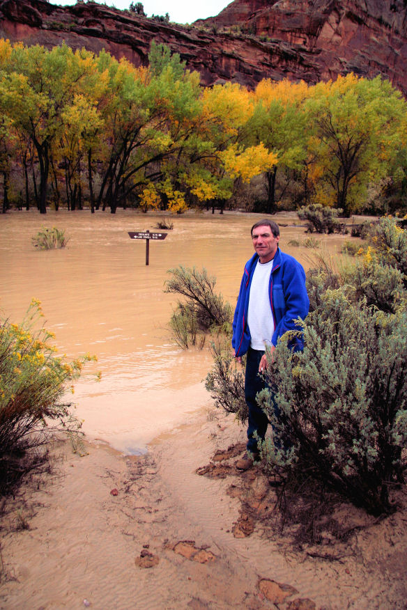
so on the last day, nat and i had a very interesting drive out, as described on the full trip report on the link. the road was very bad as it had been shockingly partially washed out in a number of places, and high clearance/4WD maneuvers were necessary. twentyfivemile wash was the worst!! and needed the most work to get across as the graded slopes to the bottom of the wash had been washed down stream and all that remained were steep terraced slopes. There was literally no inkling of a road there. after some road work ...
nat navigated it like a champ!
once we made it across twentyfive mile wash we figured that we were likely in the clear, but of course we weren't there yet. it appeared as a bad sign when we saw a ranger walking on the road. although he assured us we wouldn't be able to make it up ahead, we figured that it couldn't be as bad as twentyfive mile wash. well it was fairly bad in one spot, which nat managed to get through. in another spot, which had stopped the ranger, 2/3 of the road had been ripped through by a 6-8 foot deep trench ... fortunately the steep and elevated shoulder served to extend the road
at this point he assured us that we wouldn't have any more serious problems
we talked with him a little. he had come down this way because nat's wife had called to ensure the park's awareness of our being out there, doing technical canyons, during this storm. we talked with him a little about the storm, he said it was the biggest one he'd seen in southern utah in his 25 years on the job.
he also mentioned that over in horse canyon the flooding caused a guy's truck to be almost completely submerged in the mud. the guy was okay, but unfortunately we didn't ask if he was in or away from the vehicle when it occured. horse canyon is just a little ways north of choprock, and constitutes the main fork of the tributary system that includes wolverine canyon and the wonderful little death hollow.
well, i was looking on the road condition page for escalante, and they have posted some photos of the truck in the mud. note the damage to car.
the very useful link for road conditions is
escalante road conditions (GSENM)


-
10-28-2006 07:24 AM # ADS
-
10-28-2006, 08:03 AM #22

Thanks for posting the Escalante Road Condition link. I was unaware of its existence.
-
10-28-2006, 09:51 AM #23
looks like Toyotas don't do well when buried under 5 feet of soil...
wonder how the "lifestyle" would hold up?
-
10-28-2006, 02:57 PM #24
 Originally Posted by marc olivares

I saw a Land Rover the other day and its spare tire cover said
Hummer Recovery Vehicle

-
10-28-2006, 07:00 PM #25 Originally Posted by stefan

Nooooooooooooooooooo!! Why did it have to be a silver 4Runner!
I guess this could be an ommen:
James
-
10-28-2006, 08:58 PM #26
glad mine is gold!!
-
10-28-2006, 10:46 PM #27
well a friend of mine used to work as a warden in canyonlands. he told me a story of a guy, wife, a daughter and 2 sons who were in a hummer (of some sort) in shafer canyon and were caught in a serious flash flood. [i am not sure precisely where they were but i could find out.] anyway, this flood was apparently pretty large and swept the vehicle up. the father grabbed the two sons and swam to one side of the flooding river and the mother took the daughter to the other side and everyone was fortunately okay. but the vehicle wasn't. it was found somewhere, i think, 8 miles down the colorado river ... yes no exaggeration. it was completely submerged in mud and was a very expensive extraction which the family was required to pay. the car was totaled i guess.
the following year, my friend saw the guy back in canyonlands in a brand new hummer ...
-
10-29-2006, 08:08 AM #28
I remember when this first happened. Here is the entire Hummer story:
My Hummer Saved My Family's Lives
by Art Pollard, Provo Utah
On September 7th, 2002, my wife and two children packed into my AMG Hummer Wagon with me for a trip to CanyonLands in Moab Utah. This was supposed to be a end-of-summer trip to show my wife some of the most spectacular scenery that I
-
10-29-2006, 08:37 AM #29
wow no kiddin' eh?
thanks ice for the post ... wild story, good to get the details straight too.
i wonder how far they floated?
-
10-29-2006, 09:26 PM #30Somewhere in the story it says they floated 3 miles!!!! Originally Posted by stefan
I also was laughing about it being reported as a 100 year storm, which was the same report after some of the storms we had earlier this month.... It looks like we get a 100 year storm about every 4 or 5 years.

-
10-30-2006, 04:29 AM #31okay, i missed that. so 8 ---> 3. good i think the way i heard the story was a bit exaggerated. Originally Posted by ice vader
okay FIRST, the guy incorrectly reported that it was a ONCE EVERY 100 YEAR (or however he stated it precisely). Originally Posted by ice vader
but it should be clarified that a N-year storm is not saying that it can only occur once every hundred years, it's a measure of the size of the storm based on the probability that such a storm could occur in any one year. 100 year storm is the same as saying that such a storm has a 1% chance of happening in any given year (inverse of the probability of it occuring). but this doesn't mean that in one hundred years only one such storm will happen. there are a lot of assumptions in this as well. but the point is it should be taken more as a characterization of the size of the storm. more than one can occur within a year, especially if el nino is in effect
i spoke with the hydrologist from escalante. he said that the last time there was such a FLOOD was back in 1987-88 sometime. the hydrologist in escalante put the event there at 20-50 years, but they're still collecting data. i believe this is characterizing the FLOOD, but i am in the process of checking back with him[note that 100 year storm can be different from 100 year flood.]
i asked mr brian_noaaguy about the validity of the 50-100 year storm for the whole of southern utah, which is how i first heard it on the news. it was pretty major across the southern utah and he pointed out that hanksville's record rain of 3.75 inches in 24 hours would characterize that storm as a 500 year event. see the following link for hanksville
http://tinyurl.com/yzzn9r
he also pointed out that other areas of southern utah measured 5.75 inches. nat measured roughly 5+ inches in his cup where we were.
-
11-01-2006, 12:01 AM #32
so i snagged this a bit ago from the lake powell water database. you can see how the lake level rose within the time period of the flood. it's current elevation is 3607.96 feet.
the link is Lake Powell Water Database. from here you can access other reservoirs as well.
here's a link to an interesting graph http://graphs.water-data.com/lakepowell/index.php
and here's the table as recorded on oct. 12. one thing you notice is that lake powell rose about 5 feet in one week due to that storm.

-
11-04-2006, 01:43 PM #33

-
12-02-2006, 12:26 AM #34
on the range
-
12-02-2006, 12:41 AM #35
great video of flooding in hanksville
http://kutv.com/southernutah/local_story_279183845.html
__________________________________________________ ____
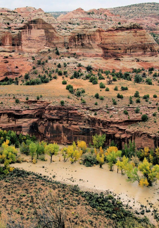
found a couple more shots in escalante taken on oct 6
from the page ... http://www.flickr.com/photos/blownaway/page3/
also here is a short excerpt from the following link (also available in pdf format)
http://tinyurl.com/w2z4w
Upper Colorado River Basin Hydrology
[color=#3D2C10]
The
-
02-23-2007, 09:54 PM #36
neat videos from clear creek in the lower escalante
october 6, 2006 ... the day of the flood
-
02-24-2007, 12:34 AM #37
Wow - cool video. Thanks for posting it!
-
02-24-2007, 08:45 AM #38
WOW! That is cool!
-
03-03-2007, 10:50 PM #39
okay ... i guess it amazes me that every time i search on the web for the october flood, i continue to find more and more related stuff!!
here are some more photos i just found.
pickup in cottonwood wash, san juan county

pickup in coomb wash, san juan county

poison spider trail

poison spider trail

riverside drive in st. george

just north of Kanab on Highway 89

bullfrog

flooding near lake powell

paria river at tropic or cannonville

hanksville

fremont river

falls, fremont river normally and during flood


-
03-04-2007, 03:33 PM #40
I like the Fremont before and during picture.


 Reply With Quote


Similar Threads
-
[Trip Report] Choprock Canyon
By shaggy125 in forum CanyoneeringReplies: 14Last Post: 06-10-2011, 09:06 PM -
[Trip Report] Choprock and Neon 3/22/2010
By CarpeyBiggs in forum CanyoneeringReplies: 24Last Post: 03-27-2010, 12:03 PM -
Middle Escalante Deluge Oct. 2006
By stefan in forum Backpacking & CampingReplies: 0Last Post: 10-04-2007, 07:47 AM -
[Trip Report] Escalante River Canyon - Escalante to the Hwy 12 Bridge
By mroy in forum Backpacking & CampingReplies: 0Last Post: 04-29-2007, 09:51 PM -
[Trip Report] choprock
By kamfoo in forum CanyoneeringReplies: 11Last Post: 06-08-2006, 07:53 PM

