Results 1 to 17 of 17
Thread: Luke's Trail -- TR
-
12-18-2005, 07:02 PM #1
Luke's Trail -- TR
Thanks to Fuzzy for providing the pics and description. This is one of the many trails down in Price, UT.
LUKE'S TRAIL: In Price, Utah Two starting-point options; either park at Pioneer Park (5th north and 1st east) and ride west & "up between the C's", following the jeep road 1 mile to the trail-head


-OR-
Drive north on 3rd east past C.E.U. and turn left (west) on 9th north. Follow the road as it turns and goes up the dugway to the top. As the road tops-out, turn left and look for a sign on your right..... Luke's Singletrack starts on the north edge of the clearing just north of the fenced-mound. It twists and winds it's way through pinion and juniper trees, cactus and sagebrush and rocks, along cliff edges and ridges. Other than a few wash-crossings, there is little actual climbing, but this trail will require you to pay attention.


This is some of the FUNNEST singletrack in the state, and when you stop to look around you'll take in a HUGE view of the Book Cliffs and Manti-La Sal National forest..... When you come to a dirt road, cross it (a few times) and continue. Once you've passed "white-trash point" (shown below) and the old fence-line, you'll come to the ONE-WAYS.

Stay on the right fork and cross another dirt road. A short climb and a left turn, and then another fork. Either go left to the bonus loop and ride luke's back (beware the switch-back on the one-way) or go right and climb a bit more to the end..... From the end of Luke's, you can bomb downhill all the way back to town (south) or ride north 1/4 mile and take Mead's Rim back to town......


A local favorite route is to take Luke's back to White Trash Point and turn left along the power-lines. Follow the lines past the dirt-road and about 1/4 mile to the hard-right turn and take the jeep trail down toward town. A quick left-right zigzag on dirt-roads, then on south to the well-pad. Drop off of the far south-east corner of the pad and rip down the DEVIL'S BACKBONE. This is a downhiller's playground and shouldn't be missed. ... BOMBS AWAY!!!
-
12-18-2005 07:02 PM # ADS
-
12-18-2005, 08:35 PM #2
Here's some Google Earth tools, to help us get there.
The image also gives us a good look at the terrain. Click on the location tool to go right to the trail, and take a look around for yourself. The resolution isn't the best, but it will show you elevation changes, and trails.
-
12-19-2005, 12:19 PM #3
I can see my old house in the Google Earth picture. 3rd one up on the left on Drexel
Mike
-
12-19-2005, 05:38 PM #4Sweet, I was wondering who's house to toilet paper this weekend!
 Originally Posted by mroy

Hey, so is this trip report pretty accurate? I hope I got it right.
-
12-19-2005, 11:53 PM #5
Looks good to me, Sorry I took me so long to get the pics hosted, I had to wait till finals were over.
SUWA Hates you, JUST SAY NO TO SUWA
"Somebody told me it was frightening how much topsoil we are losing each year, but I told that story around the campfire and nobody got scared". Jack Handy

-
12-20-2005, 01:36 PM #6
 IT'S BEAUTIFUL!!
...NOW will you come ride with us?SCREW SEA OTTER!!!!!!! http://FuzzysBicycleworks.com
-
12-20-2005, 01:45 PM #7Makes no difference to me, the current owners can deal with it, but while you're down there you should go riding with Fuzzy & his group. Originally Posted by Sombeech
Mike
-
12-20-2005, 05:11 PM #8I smell a trip to price sometime this spring. Originally Posted by Fuzzy TheBikeGuy
How's the snow right now? Any?
-
12-20-2005, 05:26 PM #9Not really. There might be a very small patch or two in the shade, not more than 1/2" deep. The trail was pretty clear a couple of days ago. Plus, it got up to 54 Originally Posted by Sombeech
-
12-20-2005, 05:37 PM #10
Wow, I may be going down earlier than I thought!
-
12-21-2005, 08:26 AM #11
High-Desert Tropics
[quote=Udink] Plus, it got up to 54
SCREW SEA OTTER!!!!!!! http://FuzzysBicycleworks.com
-
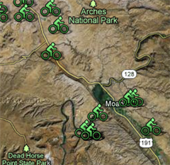
12-29-2005, 10:00 PM #12
Fuzzy's awesome map
Click for larger version:
 SUWA Hates you, JUST SAY NO TO SUWA
"Somebody told me it was frightening how much topsoil we are losing each year, but I told that story around the campfire and nobody got scared". Jack Handy
-
12-29-2005, 10:04 PM #13
here are some more pics of Fuzzy on I upload from luke's
Trail art,


I could not resist on this one
 SUWA Hates you, JUST SAY NO TO SUWA
"Somebody told me it was frightening how much topsoil we are losing each year, but I told that story around the campfire and nobody got scared". Jack Handy
-
12-29-2005, 10:25 PM #14
I just told Fuzz he should get an avatar, and this should be the one!
Thanks, G.G.!
That is an awesome map!
Thanks, man. Great pics.
-
12-30-2005, 08:19 AM #15
That map brings back some memories. I was wondering the other day if you guys had bulit the trail up in Mead's Wash. When I lived there you could only get halfway up before running out of trail. Looks like you can get all the way through it now. Then those two trails pointing up into the Book Cliffs, one time me and a buddy decided to bike up and over the mountain. It was more of a hike for a while there. Coming down the backside was tons of fun, but then we hit the river that flows along 191 and we had to wade through it, about 4.5 ft deep from the spring meltoff going on. Then we coasted down 191 to 6 and then rode back to Price. Good times.
Mike
-
12-30-2005, 10:05 AM #16I tried getting UP from that direction last year, but there's now an orange gate across the road after the corral and the river crossing. But it looks like it's only designed to keep cars out. Originally Posted by mroy

-
12-30-2005, 12:52 PM #17
I just looked it up on Google Earth. We came out Mathis Canyon. I do remember going past a gate halfway down the canyon. Don't know if this is the same one you went up.. Coming up the backside would definitely the way to go to get on top of the mountains. Then at least you'd know which roads to take back down. Some of the roads up there that are on maps have all but disappeared from decades of non-use.
Mike


 Reply With Quote


Similar Threads
-
[Trip Report] Luke's Trail - Price, Utah
By Udink in forum Mountain Biking & CyclingReplies: 2Last Post: 05-14-2010, 09:40 AM -
Bouldering Comp./ Trail Building/ Fun Trail Run/ Etc., Etc.
By Bo_Beck in forum Climbing, Caving & MountaineeringReplies: 14Last Post: 04-01-2010, 10:21 AM -
[Trip Report] TR: Zen Trail 12/21/09
By theking648 in forum Mountain Biking & CyclingReplies: 1Last Post: 12-24-2009, 10:46 PM -
[Trip Report] TR: Precipice Trail & Sidewinder Trail 5/16/09
By theking648 in forum Mountain Biking & CyclingReplies: 3Last Post: 05-19-2009, 01:17 PM -
Trail work to be done on Zion's West Rim Trail
By tanya in forum Hiking, Scrambling & Peak BaggingReplies: 0Last Post: 07-12-2007, 08:21 AM
Visitors found this page by searching for:
Outdoor Forum